ملف:Zealandia, topographic map.jpg

حجم هذه المعاينة: 529 × 600 بكسل. البعد الآخر: 1٬500 × 1٬700 بكسل.
الملف الأصلي (1٬500 × 1٬700 بكسل حجم الملف: 4٫57 ميجابايت، نوع MIME: image/jpeg)
وصف قصير
| ⧼wm-license-information-description⧽ |
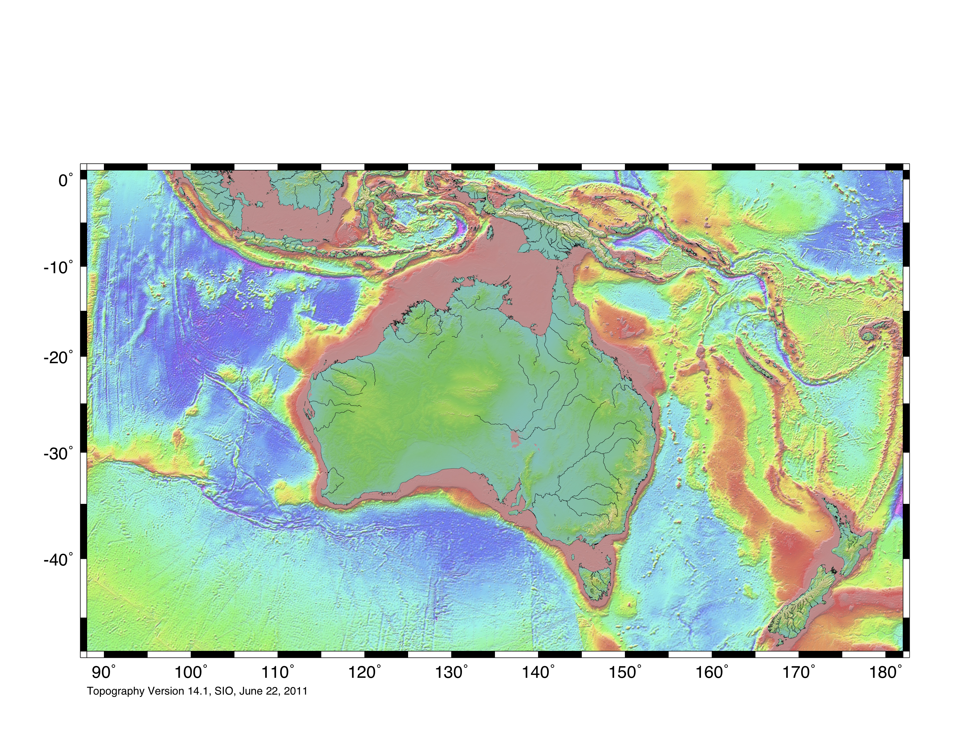
Deutsch: Die topografische Karte von Zealandia basiert auf den Bathymetrie-Daten des Scripps Institution of Oceanography, University of California, San Diego.
Die Umrandung zw. Grenzziehung basiert auf Informationen des Buches: Nick Mortimer (2014). Zealandia - Our Continent Revealed (in الإنجليزية). London: Penguin Books. p. 54. ISBN 978-0-143-57156-8. {{cite book}}: Unknown parameter |coauthors= ignored (|author= suggested) (help)English: Topographic map of Zealandia, based on bathmetry data from Scripps Institution of Oceanography, University of California, San Diego.
Boundary is based on information which was given in: Nick Mortimer (2014). Zealandia - Our Continent Revealed (in الإنجليزية). London: Penguin Books. p. 54. ISBN 978-0-143-57156-8. {{cite book}}: Unknown parameter |coauthors= ignored (|author= suggested) (help)Français : Carte topographique du continent de Zealandia, basée sur des données bathymétriques du Scripps Institution of Oceanography, Université de Californie, San Diego, États-Unis.
La limite du continent est tirée d'informations venant de : « Nick Mortimer (2014). Zealandia - Our Continent Revealed (in الإنجليزية). Londres: Penguin Books. p. 54. ISBN 978-0-143-57156-8. {{cite book}}: Unknown parameter |coauthors= ignored (|author= suggested) (help) ». |
| ⧼wm-license-information-date⧽ | 2017 |
| ⧼wm-license-information-source⧽ | http://topex.ucsd.edu/WWW_html/mar_topo.html; http://topex.ucsd.edu/marine_topo/jpg_images/topo10.jpg; http://topex.ucsd.edu/marine_topo/jpg_images/topo11.jpg; http://topex.ucsd.edu/marine_topo/jpg_images/topo14.jpg; http://topex.ucsd.edu/marine_topo/jpg_images/topo15.jpg |
| ⧼wm-license-information-author⧽ | Ulrich Lange, Bochum, Germany |
There is no copyright on published bathmetry data, (free use)
ترخيص
تاريخ الملف
اضغط على زمن/تاريخ لرؤية الملف كما بدا في هذا الزمن.
| زمن/تاريخ | صورة مصغرة | الأبعاد | مستخدم | تعليق | |
|---|---|---|---|---|---|
| حالي | ★ مراجعة معتمدة 18:41، 30 أكتوبر 2023 | | 1٬500 × 1٬700 (4٫57 ميجابايت) | Pastakhov (نقاش | مساهمات) | Upload https://upload.wikimedia.org/wikipedia/commons/1/12/Zealandia%2C_topographic_map.jpg |
لا يمكنك استبدال هذا الملف.
وصلات
الصفحات التالية تحتوي على وصلة لهذه الصورة: