وادي هنزة
| وادي هنزة | |
|---|---|
| Hunza Valley | |
.jpg&filetimestamp=20251012205241&) The 7،788 متر (25،551 ft) tall Rakaposhi mountain towers over Hunza Valley | |
 وادي هنزة  وادي هنزة | |
| المساحة | 11،660 km2 (4،500 sq mi) |
| الجغرافيا | |
| البلد | تديره پاكستان في منطقة كشمير المُتنازع عليها |
| الولاية/المقاطعة | گلگت-بلتستان |
| المقاطعة | هنزة |
| الإحداثيات | خطأ في التعبير: علامة ترقيم لم نتعرف عليها «,».km 36°19′01″N 74°39′00″E / 36.316942°N 74.649900°E [1] |
| النهر | Hunza |
هونزا منطقة في الطرف الشمالي لباكستان. تقع في الجزء الذي تحكمه باكستان في كشمير، وذلك بالقرب من حدودها مع أفغانستان والصين وتغطي هونزا مساحة تقرب من 10,100 كم²، ويبلغ عدد سكانها حوالي 30 ألف نسمة. تعد مدينة كريم أباد أكبر مدن هونزا. وهناك طريق جبلي يمر عبر الوادي من جلجت.
تتكون هونزا من وادٍ طويل ضيق في سلسلة جبال كراكورام، ومعظم مواطني هونزا يعملون في زراعة المحاصيل المتنوعة مثل الشعير والعنب والبرقوق والقمح. وأهم الصناعات الرئيسية فيها إنتاج الأقمشة الصوفية والصناعات اليدوية الدقيقة.
التاريخ
 مقالة مفصلة: إمارة هنزة

كانت البوذية، وبدرجة أقل، البون، الديانتين الرئيسيتين في المنطقة.[2] تضم المنطقة العديد من المواقع الأثرية البوذية الباقية، مثل صخرة هونزا المقدسة. كان وادي هونزا محوريًا في شبكة طرق التجارة التي تربط آسيا الوسطى بشبه القارة الهندية. كما وفر الحماية للمبشرين والرهبان البوذيين الذين زاروا شبه القارة الهندية، ولعب دورًا هامًا في نشر البوذية في جميع أنحاء آسيا.[3]
قبل وصول الإسلام، كان غالبية سكان المنطقة يعتنقون البوذية. ومنذ ذلك الحين، اعتنق معظمهم الإسلام، وغالبيتهم من أتباع الطائفة الإسماعيلية. تزخر المنطقة بالعديد من أعمال الجرافيتي بالخط البراهمي القديم على الصخور، التي أنجزها الرهبان البوذيون كشكل من أشكال العبادة والثقافة.[4] مع اعتناق معظم السكان الإسلام، تُركت هذه الأعمال مهملة أو مدمرة أو منسية، لكنها الآن قيد الترميم.[5]
هنزة Hunza كانت سابقاً إمارة يحدها الصين من الشمال الشرقي وجبال پامير من الشمال الغربي، وقد استمرت في الوجود حتى 1974، عندما حلها نهائياً ذو الفقار علي بوتو. كما جاورت الإمارة وكالة گلگت إلى الجنوب، وإمارة نگر السابقة إلى الشرق. عاصمة الإمارة كانت بلدة بلتيت (وتُعرف كذلك بإسم كريم أباد) ومستوطنتها القديمة قرية گانيش التي تعني "قرية بابا گانيش" (a Hindu name, Ganesh being name of a hindu deity).[6] كانت هنزة إمارة مستقلة لأكثر من 900 عام، وفي مطلع القرن التاسع عشر لعبت هنزة دوراً حيوياً في "اللعبة الكبرى" البريطانية. وفي 1891، استولى الراج البريطاني على هنزة ووادي نگر المجاور. ثم أعقب ذلك اشتباك عسكري محتدم الوطيس. ثـُمْ (أمير) مير صفدار علي خان من الهنزة فر إلى قشغر في الصين وطلب ما يمكن تسميته لجوء سياسي. وقام الجيش البريطاني بتعيين شقيقه مير نظيم خان (1892-1938) كحاكم دمية على وادي هنزة، إلا أن الأوامر كانت تصدر من الضباط البريطانيين المُعينين في العاصمة گلگت.[7]
مير هنزة

وفقًا لرواية كتبها جون بيدولف في كتابه Tribes of the Hindoo Koosh:
تُسمى العائلة الحاكمة في هونزا عائشة "آية شاه" (السماوية). كانت ولايتا هونزا وناجر دولة واحدة سابقًا، يحكمها فرع من الشهري، العائلة الحاكمة في گلگت، وكان مقر حكومتها وادي نجار. وصل المسلمون أولًا إلى وادي هونزا-ناجر منذ حوالي ألف عام (في عهد الإمام إسلام شاه، الإمام الإسماعيلي الثلاثون). بعد دخول الإسلام إلى گلگت، تزوج من ابنة تراخان من گلگت، وأنجبا ولدين توأمين، هما مغلوت وجركس. من الأولى، تنحدر عائلة ناجر الحاكمة الحالية. يُقال إن التوأمين أظهرا عداوة لبعضهما البعض منذ ولادتهما. وبعد ذلك، لم يتمكن والدهم من تسوية مسألة الخلافة، فقام بتقسيم ولايته بينهم، فأعطى جركس الضفة الشمالية الغربية، ولموغلوت الضفة الجنوبية الشرقية للنهر.[8]
الانزلاقات الطينية 2010


في 4 يناير 2010، سد انزلاق طيني النهر وخلق بحيرة عطا أباد (وتسمى أيضاً بحيرة شيشكت)، التي يهدد انهيارها المحتمل إغراق الوادي أسفلها، ومقتل 20 شخص وجرح ثمانية، وقطع 26 كم من طريق قرة قرم.[9][10][11][12] تمتد البحيرة الجديدة 30 كيلومترًا (19 ميلًا) وارتفعت إلى عمق 400 قدم (120 م) عندما تشكلت مع احتياطي نهر هونزا.[13] غطى الانهيار الأرضي أجزاء من طريق كاراكورام السريع بالكامل.[10][13]
مهمة الإنقاذ في 2018
في 1 يوليو 2018، أنقذ طيارو الجيش الباكستاني ثلاثة متسلقي جبال أجانب كانوا عالقين في انهيار جليدي على ارتفاع يزيد عن 19000 قدم على قمة جبل أولتار سار بالقرب من هونزا. وقد حالت الظروف الجوية دون تمكن مروحية الجيش من تنفيذ عملية الإنقاذ على ارتفاع 7388 مترًا. ومع ذلك، فقد نجحوا في إتمام العملية. وتم إنقاذ بروس نورماند وتيموثي ميلر من المملكة المتحدة بنجاح، بينما لقي رفيقهما كريستيان هوبر من النمسا حتفه في الانهيار الجليدي.[14][15] ووصف المفوض السامي البريطاني في باكستان، توماس درو، المهمة بأنها "رائعة وخطيرة".[16][17]
السياحة
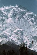
Rakaposhi, 7,788 متر
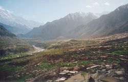
نهر بوادي هنزة
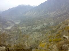
كريم أباد، هنزة


The Hunza Valley is home to several high peaks that rise above 7,000 m in its the surroundings. These include Rakaposhi, Distaghil Sar, Batura, Batura II, Batura III, Muchu Chhish, Kunyang Chhish, Shispare, Passu Sar, Kanjut Sar, Yukshin Gardan Sar, Pumari Chhish, and Momhil Sar.
The valley provides views of several mountains, including Ultar Sar 7,388 m (24,239 ft), Bojahagur Duanasir II 7,329 m (24,045 ft), Ghenta Peak 7,090 m (15,631 ft), Hunza Peak 6,270 m (20,571 ft), Darmyani Peak 6,090 m (19,980 ft), and Bublimating (Ladyfinger Peak) 6,000 m (19,685 ft).
Hunza Valley has a diverse religious history with it being home to several historic religious sites like the ancient watchtowers in Ganish village, Baltit Fort on top of karimabad which was built by the Mirs about 800 years ago , which is a historic landmark for hunza and Altit Fort (at the bottom of the valley).
Hunza also houses several lakes in its vicinity including Attabad Lake, Borith Lake, Shimshal Lakes, Hassanabad Lake. It is also home to the 57 km long Batura Glacier, the fifth-longest glacier in the world outside the polar region,[18] is surrounded by Shispare, Batura, and Kumpirdior peaks.
The Khunjerab Pass, standing at a height of 4,693 meters (over 15,000 feet above sea level), is the highest paved international border crossing in the world. Strategically located on Pakistan's northern border and China's southwest border, it connects the two countries via Gilgit-Baltistan, making it a significant landmark of the Hunza Valley.[19] Hiking treks include Ondra Poygah Gulmit and Leopard Trek Shiskhat.[20]
The valley is popularly believed to be one of the inspiration for the mythical valley of Shangri-La in James Hilton's 1933 novel, Lost Horizon.[21]
السكان


The local languages spoken include Burushaski, Wakhi and Shina. The literacy rate of the Hunza valley is more than 95%. The establishment of community schools that provide high quality education, and the influence of the Aga Khan Mirs, contributing towards building universities for higher education have directed towards the high literacy rate in Hunza Valley, especially for girls.[22] The historical area of Hunza and present northern Pakistan has had, over the centuries, mass migrations, conflicts and resettling of tribes and ethnicities, of which the Shina people are the most prominent in regional history. People of the region have recounted their historical traditions down the generations. The Hunza Valley is also home to some Wakhi, who migrated there from northeastern Afghanistan beginning in the nineteenth century onwards.[23] The majority of residents in Hunza belong to the Ismaili Shia sect. They believe that Aga Khan V is their religious figurehead and transcendent. He is also believed to be the biggest promotor and contributor towards the literacy success and overall well-being of the people of Hunza and the valley itself.[21]
The longevity of Hunza people has been noted by some,[24] but others refute this as a longevity myth promoted by the lack of birth records.[25] There is no evidence that Hunza life expectancy is significantly above the average of poor, isolated regions of Pakistan. Claims of health and long life were almost always based solely on the statements by the local mir (king). An author who had significant and sustained contact with Burusho people, John Clark, reported that they were overall unhealthy.[26]
However, whether or not their putative longevity is true, it is undoubtable that the Hunza people lead a healthy lifestyle along with a healthy diet. Many researchers have lived with the Hunza people to answer this mystery including Robert McCarrison who did not discover a single person with diseases such as cancer, stomach ulcers or appendicitis. The research shows that high levels of exercise due the landscape and geography allows for them to be active and agile which factors in with their longevity , along with consumption of apricot seeds and oils, and the glacier water which contains minerals.[27]
التقسيمات الجغرافية والإدارية
تنقسم منطقة هنزه إلى ثلاثة أقسام
وادی گوجال (هنزه العليا) وهي المنطقة التي تشمل ضلع هنزه (أي مقاطعة هنزه) (بالأردويَّة: ضلع ہنزہ)
هنزه الوسطى وهي المنطقة التي تقع بأجزاء من تحصيل علي أباد حيث يكون المركز التجاري لوادي هنزه. وتحتوي هذه المنطقة على قلعتين تاريخيتين هما: قلعة بلتِت (بالأردويَّة: قلعہ بلتت) وقلعة التيت (بالأردويَّة: قلعہ التیت).
هنزه السفلى وهي المنطقة التي تقع بأجزاء من تحصيل علي أباد حيث يكون المركز التجاري لوادي هنزه. تقع بها عدد من البلدات من مثل ناصر آباد وحسین آباد وخضر آباد.
المناخ

المواصلات
شعب هنزة
ويعمّر كثير من سكان هونزا إلى أكثر من تسعين عاماً. ويعتقدون أن المياه الجبلية الغنية بالمواد المعدنية واتباع حمية متواضعة من التغذية هما سبب طول أعمارهم. ويتكون النظام الغذائي الخاص بهم بصفة رئيسية من الفواكه كالمشمش والخوخ والحبوب والمكسرات والخضراوات. ويتكلم معظم سكان هونزا لغة تسمى يوروشاسكي ولكن ليس لديهم لغة مكتوبة. ومعظم مواطني هونزا من المسلمين، كما أن العطلات الدينية الإسلامية مهمة جداً بالنسبة لهم.
لا أحد يعرف من أول من سكن فيما يسمى الآن بهونزا. إذ تقول إحدى الأساطير إن ثلاثة جنود من جيش الإسكندر الأكبر قد استوطنوا هناك مع زوجاتهم الفارسيات وذلك منذ القرن الرابع قبل الميلاد. ولقد كانت هونزا دولة منعزلة يحكمها واحد من المير (الأمير) وقد بسطت باكستان سيطرتها على هونزا في عام 1949م تطبيقاً للمعاهدة التي أقرتها هيئة الأمم المتحدة التي أنهت الصراع بين باكستان والهند في كشمير. ولقد كان يُسمح للأمير بالتحكّم في الشؤون المحلية للبلاد حتى عام 1974م عندما سيطرت باكستان سيطرة كاملة على البلاد.
ضلع جديد
أصبحت هونزا-ناجار منطقة جديدة في گلگت-بلتستان اعتبارًا من يوليو 2009. ومن المخطط أن يكون هناك مقعد في جمعية المجلس التشريعي للمناطق الشمالية (NALA) لهونزا.[28]
انظر أيضاً
- دولة هنزة السابقة
- حصن بلتيت
- حصن ألتيت
- المناطق الشمالية
- طريق قرةقرم
- جبال قرةقرم
- وادي نگر
- Burusho
- قرية گانيش
- كريم أباد
- خضر أباد
- ناصر أباد
- أحمد أباد
- حسين أباد
- مرتضى أباد
- سيكندر أباد
- جعفر أباد
- ضلع هنزة-نگر
- حيدر أباد، هنزة
الهامش
- ^ "Rakaposhi Nagar on Google Maps". Google Maps. Retrieved 27 June 2018.
- ^ Neelis, Jason (2011). "Capillary Routes of the Upper Indus". Early Buddhist Transmission and Trade Networks (in الإنجليزية). Brill: 257–288. doi:10.1163/ej.9789004181595.i-372.34. JSTOR 10.1163/j.ctt1w8h16r.11.
- ^ Behrendt, Kurt (2003). The Buddhist Architecture of Gandhāra. BRILL. p. 25. ISBN 978-90-474-1257-1.
- ^ Susan E. Alcock; John Bodel; Richard J. A. Talbert (15 May 2012). Highways, Byways, and Road Systems in the Pre-Modern World. John Wiley & Sons. pp. 21–. ISBN 978-0-470-67425-3.
- ^ Zara Khan, Vandalized Buddhist inscriptions in Gilgit-Baltistan are now being restored, Mashable Pakistan, 28 May 2020.
- ^ (in en)History of Hunza, 12 December 2011, https://www.youtube.com/watch?v=xRZweSmnAhE, retrieved on 2021-10-02
- ^ Valley, Hunza. "Hunza Valley". skardu.pk. Archived from the original on 11 November 2016. Retrieved 23 November 2016.
- ^ Tribes of the Hindoo Koosh by John Biddulph page 26
- ^ Waheed, Abdul (4 January 2013). "The Attabad Landslide Disaster". Pamir Times. Archived from the original on 12 October 2019. Retrieved 12 October 2019.
- ^ أ ب Ahmed, Kamran (23 May 2010). "Pakistan: The water bomb". ReliefWeb. Dawn. Retrieved 27 August 2022.
- ^ "Annual Report 2011". Yumpu. National Disaster Management Authority, Government of Pakistan. pp. 40–41. Retrieved 27 August 2022.
- ^ "SHISHKET LAKE CRISES – 2010 – CHRONOLOGY OF EVENTS" (PDF). ndma.gov.pk. NDMA. 27 July 2010. Retrieved 12 October 2019.[dead link]
- ^ أ ب Michael Bopp; Judie Bopp (May 2013). "Needed: a second green revolution in Hunza" (PDF). HiMaT. p. 4. Archived (PDF) from the original on 27 November 2015. Retrieved 26 November 2015. Karakorum Area Development Organization (KADO), Aliabad
- ^ "Pakistan Army Pilots rescued 3 foreign mountaineers". en.dailypakistan.com.pk. July 2018. Archived from the original on 7 July 2018. Retrieved 7 July 2018.
- ^ "Mountainers News on Thenews.com.pk". thenews.com.pk. Archived from the original on 7 July 2018. Retrieved 7 July 2018.
- ^ Farmer, Ben (July 2018). "Britain's High Commissioner in Pakistan admired Pak Army Pilots for rescued the two British Climbers". The Telegraph. London. Archived from the original on 12 July 2018. Retrieved 8 July 2018.
- ^ "Major General Asif Ghafoor also tweeted about it". forces.net. 2 July 2018. Archived from the original on 12 July 2018. Retrieved 12 July 2018.
- ^ "Earth from Space: Batura Glacier". www.esa.int (in الإنجليزية). Retrieved 2024-03-21.
- ^ shahid, ariba (October 20, 2023). "Khunjerab Pass linking Pakistan, China to stay open all year round". Reuters.
- ^ admin (2021-07-12). "Amazing Views of Hunza Valley…". Trip Venture (in الإنجليزية الأمريكية). Retrieved 2022-04-19.
- ^ أ ب Craig, Tim (2023-04-10). "High up on a Pakistani mountain, a success story for moderate Islam". Washington Post (in الإنجليزية الأمريكية). ISSN 0190-8286. Retrieved 2024-03-28.
- ^ Siddiqui, Shahid. "Hunza disaster and schools". Dawn. Pakistan. Retrieved 6 July 2012.
- ^ Frembgen Wasim, Jurgen (2017). The Arts and Crafts of the Hunza Valley in Pakistan: Living traditions in the Karakoram. Karachi: Oxford University Press. p. 1. ISBN 978-0-19-940520-6.
- ^ Wrench, Guy T., Dr. (2009) [1938]. The Wheel of Health: A study of the Hunza people and the keys to health (reprint ed.). Review Press. ISBN 978-0-9802976-6-9. Retrieved 12 August 2010.
{{cite book}}: CS1 maint: multiple names: authors list (link) - ^ Tierney, John (29 September 1996). "The optimists are right". The New York Times.
- ^ Clark, John. "Hunza – the truth, myths, and lies about the health and diet of the "long-lived" people of Hunza, Pakistan – Hunza bread and pie recipes". biblelife.org. Archived from the original on 9 August 2018. Retrieved 31 July 2018.
- ^ Shea, Samantha (17 February 2024). "People in this remote valley live to 100—they follow 5 distinct diet and lifestyle habits for longevity". www.cnbc.com (in الإنجليزية). CNBC. Retrieved 24 March 2024.
- ^ [1] HunzaTimes, June 24, 2009.
- Kreutzmann, Hermann, Karakoram in Transition: Culture, Development , and Ecology in the Hunza Valley, Oxford University Press, 2006. ISBN 9780195472103
- Leitner, G. W. (1893): Dardistan in 1866, 1886 and 1893: Being An Account of the History, Religions, Customs, Legends, Fables and Songs of Gilgit, Chilas, Kandia (Gabrial) Yasin, Chitral, Hunza, Nagyr and other parts of the Hindukush, as also a supplement to the second edition of The Hunza and Nagyr Handbook. And An Epitome of Part III of the author’s “The Languages and Races of Dardistan.” First Reprint 1978. Manjusri Publishing House, New Delhi.
- Lorimer, Lt. Col. D.L.R. Folk Tales of Hunza. 1st edition 1935, Oslo. Three volumes. Vol. II, republished by the Institute of Folk Heritage, Islamabad. 1981.
- Sidkey, M. H. "Shamans and Mountain Spirits in Hunza." Asian Foklore Studies, Vol. 53, No. 1 (1994), pp. 67–96.
- History of Ancient Era Hunza State By Haji Qudratullah Beg English Translation By Lt Col (Rtd) Saadullah Beg, TI(M)
- Articles with dead external links from September 2023
- CS1 الإنجليزية الأمريكية-language sources (en-us)
- Short description is different from Wikidata
- Pages using gadget WikiMiniAtlas
- Articles with hatnote templates targeting a nonexistent page
- Pakistan articles missing geocoordinate data
- All articles needing coordinates
- وديان باكستان
- هنزة
- تراث باكستان قبل الإسلام
- هندو كوش