يوتا
Utah | |
|---|---|
| الكنية: "Beehive State" (official), "The Mormon State", "Deseret" | |
| الشعار: Industry | |
| النشيد: "Utah...This Is the Place" "Utah, We Love Thee" | |
 خريطة الولايات المتحدة، موضح فيها Utah | |
| البلد | الولايات المتحدة |
| قبل الولائية | Utah Territory |
| انضمت للاتحاد | January 4, 1896 (45th) |
| العاصمة (وأكبر مدينة) | Salt Lake City |
| أكبر منطقة عمرانية | Salt Lake City |
| الحكومة | |
| • الحاكم | Spencer Cox (R) |
| • نائب الحاكم | Deidre Henderson (R) |
| المجلس التشريعي | State Legislature |
| • المجلس العلوي | State Senate |
| • المجلس السفلى | House of Representatives |
| القضاء | Utah Supreme Court |
| سناتورات الولايات المتحدة | Mike Lee (R) John Curtis (R) |
| وفد مجلس النواب | 1: Blake Moore (R) 2: Celeste Maloy (R) 3: Mike Kennedy (R) 4: Burgess Owens (R) (القائمة) |
| المساحة | |
| • الإجمالي | 84٬899 ميل² (219٬887 كم²) |
| • البر | 82٬144 ميل² (212٬761 كم²) |
| • الماء | 2٬755 ميل² (7٬136 كم²) 3.25% |
| ترتيب المساحة | 13th |
| الأبعاد | |
| • الطول | 350 mi (560 km) |
| • العرض | 270 mi (435 km) |
| المنسوب | 6٬100 ft (1٬860 m) |
| أعلى منسوب | 13٬534 ft (4٬120٫3 m) |
| أوطى منسوب | 2٬180 ft (664٫4 m) |
| التعداد (2024) | |
| • الإجمالي | |
| • الترتيب | 30th |
| • الكثافة | 36٫53/sq mi (14٫12/km2) |
| • ترتيب الكثافة | 41st |
| • الدخل الأوسط للأسرة | $93٬400 (2023)[5] |
| • ترتيب الدخل | 8th |
| صفة المواطن | Utahn[ب] |
| اللغة | |
| • اللغة الرسمية | English |
| منطقة التوقيت | UTC−07:00 (Mountain) |
| • الصيف (التوقيت الصيفي) | UTC−06:00 (MDT) |
| اختصار البريد | UT |
| ISO 3166 code | US-UT |
| الاختصار التقليدي | Ut. |
| خط العرض | 37° N to 42° N |
| خط الطول | 109°3′ W to 114°3′ W |
| الموقع الإلكتروني | utah |
 علم Utah | |
 شعار Utah | |
 درع Utah | |
| الشعار | Beehive[9] |
|---|---|
| رموز حية | |
| الطائر | California gull |
| السمك | Bonneville cutthroat trout[10] |
| الزهرة | Sego lily |
| الحشائش | Indian ricegrass |
| الحشرة | Western honey bee |
| الثديي | Rocky Mountain elk |
| عش الغراب | Porcini |
| الزاحف | Gila monster |
| الشجرة | Quaking aspen |
| رموز جامدة | |
| الرقصة | Square dance |
| الديناصور | Utahraptor |
| السلاح الناري | Browning M1911 |
| الأحفورة | Allosaurus |
| الحجر الكريم | Topaz |
| المعدن | Copper[10] |
| الصخر | Coal[10] |
| الترتان | Utah State Centennial Tartan |
| علامة طريق ولائي | |
 | |
| ربع دولار الولاية | |
 طـُرِح في 2007 | |
| قوائم رموز الولايات الأمريكية | |
Utah[ت][ث] هي إحدى ولايات الولايات المتحدة الأمريكية، الواقعة في منطقة جبال الروكي. يتبع حوالي 70 % من سكانها كنيسة يسوع المسيح لقديسي اليوم الأخير. ويبلغ عدد سكانها 1,727,784 نسمة. ويُعرف أعضاء هذه الكنيسة بالمورمون. وتعُد مدينة سولت ليك، عاصمة الولاية وأكبر مدنها، هي المركز الرئيسي للكنيسة ومركزًا تجاريًا وصناعيًا. It is one of the Four Corners states, sharing a border with Arizona, Colorado, and New Mexico. It also borders Wyoming to the northeast, Idaho to the north, and Nevada to the west. In comparison to all the U.S. states and territories, Utah, with a population of just over three million, is the 13th largest by area, the 30th most populous, and the 11th least densely populated. Urban development is mostly concentrated in two regions: the Wasatch Front in the north-central part of the state, which includes the state capital, Salt Lake City, and is home to roughly two-thirds of the population; and Washington County in the southwest, which has approximately 180,000 residents.[11] Most of the western half of Utah lies in the Great Basin.
Utah has been inhabited for thousands of years by various indigenous groups, such as the ancient Puebloans, the Navajo, and the Ute. The first Europeans to arrive – in the mid-16th century – were the Spanish. Because of the region's challenging geography and harsh climate, it only became a peripheral part of New Spain (and later of Mexico). Even while it was Mexican territory, many of the Utah region's earliest European settlers were from the United States; notable among these were Mormons who were fleeing marginalization and persecution in the United States and arrived via the so-called Mormon Trail. In 1848, after the Mexican–American War, the region was annexed by the U.S., becoming part of the Utah Territory, which included what later became Colorado and Nevada. Disputes between the dominant Mormon community and the federal government delayed Utah's admission as a state: in 1896, after it agreed to outlaw polygamy, it was admitted as the 45th state.
People from Utah are known as Utahns.[6] Slightly over half of all Utahns are Mormons, the vast majority of whom are members of the Church of Jesus Christ of Latter-day Saints (LDS Church), which has its world headquarters in Salt Lake City;[12] Utah is the only state where a majority of the population belongs to a single church.[13] The LDS Church greatly influences Utah's culture, politics, and daily life.[14] However, since the 1990s, Utah has become both more religiously diverse and more secular.
Utah has a highly diversified economy, with major sectors including transportation, education, information technology and research, government services, mining, multi-level marketing, and tourism.[15] Utah has been one of the fastest growing states since 2000,[16] with the 2020 U.S. census confirming the fastest population growth in the nation since 2010. St. George was the fastest-growing metropolitan area in the United States from 2000 to 2005.[17] It has the 12th-highest median average income and the least income inequality of any U.S. state. Over time and influenced by climate change, droughts in Utah have been increasing in frequency and severity,[18] putting a further strain on Utah's water security and impacting the state's economy.[19]
أصل الاسم
The name Utah derives from the name of the Ute tribe, meaning 'people of the mountains'.[20] However, no such word exists in the Utes' language, and the Utes refer to themselves as Noochee. The meaning of Utes as 'the mountain people' has been attributed to the neighboring Pueblo Indians,[21] as well as to the Apache word Yuttahih, which means 'one that is higher up' or 'those that are higher up'.[20] In Spanish, it was pronounced Yuta; subsequently, English-speaking people may have adapted the word as Utah.[22]
التاريخ
من المحتمل أن يكون الهنود قد عاشوا في منطقة يوتا قبل عدة آلاف من السنين. وقد وجد المكتشفون الأسبان الذين وصلوا في عام 1776م، بعض القبائل الهندية مثل جُوسْيُوتي وبايوتي وشُوشون ويُوتي.
استقر المورمون الأوائل، بقيادة بريگم يونگ في منطقة يوتا عام 1847م وسموا المنطقة الصحراء التي تعني عند المورمون العسَّالة؛ أي النحلة التي تعطي العسل، وترمز للعمل الدؤوب والصناعة. والاسم المستعار لولاية يوتا هو خلية النحل. وفي عام 1850م، قرر مجلس الشيوخ الأمريكي تسمية الإقليم يوتا، نسبة إلى قبيلة يوتي الهندية التي تسكن الإقليم. أصبحت يوتا ولاية أمريكية في الرابع من يناير عام 1896. وخلال الخمسينيات والستينيات من القرن العشرين تغيرت يوتا من ولاية زراعية إلى ولاية صناعية. ومع بداية الثمانينيات، توسعت الخدمات الصناعية والسياحية.
قبل كلومبس

Thousands of years before the arrival of Europeans, the Ancestral Puebloans and the Fremont people lived in what is now known as Utah, some of which spoke languages of the Uto-Aztecan group. Ancestral Pueblo peoples built their homes through excavations in mountains, and the Fremont people built houses of straw before disappearing from the region around the 15th century.
Another group of Native Americans, the Navajo, settled in the region around the 18th century. In the mid-18th century, other Uto-Aztecan tribes, including the Goshute, the Paiute, the Shoshone, and the Ute people, also settled in the region. These five groups were present when the first European explorers arrived.[23][24]
الاستكشاف الإسباني (1540)
The southern Utah region was explored by the Spanish in 1540, led by Francisco Vázquez de Coronado while looking for the legendary Cíbola. A group led by two Catholic priests—sometimes called the Domínguez–Escalante expedition—left Santa Fe in 1776, hoping to find a route to the coast of California. The expedition traveled as far north as Utah Lake and encountered the native residents. The Spanish made further explorations in the region but were not interested in colonizing the area because of its desert nature. In 1821, the year Mexico achieved its independence from Spain, the region became known as part of its territory of Alta California.
European trappers and fur traders explored some areas of Utah in the early 19th century from Canada and the United States. The city of Provo, Utah, was named for one Étienne Provost, who visited the area in 1825. The city of Ogden, Utah, was named after Peter Skene Ogden, a Canadian explorer who traded furs in the Weber Valley.
In late 1824, Jim Bridger became the first known English-speaking person to sight the Great Salt Lake. Due to the high salinity of its waters, he thought he had found the Pacific Ocean; he subsequently learned this body of water was a giant salt lake. After the discovery of the lake, hundreds of American and Canadian traders and trappers established trading posts in the region. In the 1830s, thousands of migrants traveling from the Eastern United States to the American West began to make stops in the region of the Great Salt Lake, then known as Lake Youta.[25]
مستوطنة قديسي اليوم الآخر (1847)

Following the death of Joseph Smith in 1844, Brigham Young, as president of the Quorum of the Twelve, became the leader of the LDS Church in Nauvoo, Illinois.[26] To address the growing conflicts between his people and their neighbors, Young agreed with Illinois Governor Thomas Ford in October 1845 that the Mormons would leave by the following year.[27]
Young and the first group of Mormon pioneers reached the Salt Lake Valley on July 24, 1847. Over the next 22 years, more than 70,000 pioneers crossed the plains and settled in Utah.[28] For the first few years, Brigham Young and the thousands of early settlers of Salt Lake City struggled to survive. The arid desert land was deemed desirable by the Mormons as a place where they could practice their religion without harassment.
Settlers buried thirty-six Native Americans in one grave after an outbreak of measles occurred during the winter of 1847.[29]
The first group of settlers brought three African slaves with them, making Utah the only place in the western United States to have African slavery.[30] The three slaves, Green Flake, Hark Lay, and Oscar Crosby, came west with the first group of settlers in 1847.[31]
Utah was a Mexican territory when the first pioneers arrived in 1847. Early in the Mexican–American War in late 1846, the United States had taken control of New Mexico and California. The entire Southwest became U.S. territory upon the signing of the Treaty of Guadalupe Hidalgo, February 2, 1848. The treaty was ratified by the United States Senate on March 11. Learning that California and New Mexico were applying for statehood, the settlers of the Utah area (originally having planned to petition for territorial status) applied for statehood with an ambitious plan for a State of Deseret.
The Mormon settlements provided pioneers for other settlements in the West. Salt Lake City became the hub of a "far-flung commonwealth"[32] of Mormon settlements. With new church converts coming from the East and around the world, Church leaders often assigned groups of church members as missionaries to establish other settlements throughout the West. They developed irrigation to support fairly large pioneer populations along Utah's Wasatch front (Salt Lake City, Bountiful and Weber Valley, and Provo and Utah Valley).[33] Throughout the remainder of the 19th century, Mormon pioneers established hundreds of other settlements in Utah, Idaho, Nevada, Arizona, Wyoming, California, Canada, and Mexico—including in Las Vegas, Nevada; Franklin, Idaho (the first European settlement in Idaho); San Bernardino, California; Mesa, Arizona; Star Valley, Wyoming; and Carson Valley, Nevada.
Prominent settlements in Utah included St. George, Logan, and Manti (where settlers completed the LDS Church's first three temples in Utah, each started after but finished many years before the larger and better-known temple built in Salt Lake City was completed in 1893), as well as Parowan, Cedar City, Bluff, Moab, Vernal, Fillmore (which served as the territorial capital between 1850 and 1856), Nephi, Levan, Spanish Fork, Springville, Provo Bench (now Orem), Pleasant Grove, American Fork, Lehi, Sandy, Murray, Jordan, Centerville, Farmington, Huntsville, Kaysville, Grantsville, Tooele, Roy, Brigham City, and many other smaller towns and settlements. Young had an expansionist view of the territory that he and the Mormon pioneers were settling, calling it Deseret—which according to the Book of Mormon was an ancient word for "honeybee". This is symbolized by the beehive on the Utah flag, and the state's motto, "Industry".[34]
إقليم يوتا (1850–1896)


The Utah Territory was much smaller than the proposed state of Deseret, but it still contained all of the present states of Nevada and Utah as well as pieces of modern Wyoming and Colorado.[35] It was created with the Compromise of 1850, and Fillmore, named after President Millard Fillmore, was designated the capital. The territory was given the name Utah after the Ute tribe of Native Americans. Salt Lake City replaced Fillmore as the territorial capital in 1856.
By 1850, there were around 100 black people in the territory, the majority of whom were slaves.[36] In Salt Lake County, 26 slaves were counted.[29] In 1852, the territorial legislature passed the Act in Relation to Service and the Act for the relief of Indian Slaves and Prisoners formally legalizing slavery in the territory. Slavery was abolished in the territory during the Civil War.
In 1850, following a period of increasing tensions with the Timpanogos, Salt Lake City sent out a force known as the Nauvoo Legion, composed of 90 mormon militiamen, and attacked an encampment of Timpanogos in what was called the Battle at Fort Utah, but would later be known as the 'Provo River massacre', in which between 40 and 100 Native Americans were killed.[37]
Disputes between the Mormon inhabitants and the U.S. government intensified due to the practice of plural marriage, or polygamy, among members of the LDS Church. The Mormons were still pushing for the establishment of a State of Deseret with the new borders of the Utah Territory. Most, if not all, of the members of the U.S. government opposed the polygamous practices of the Mormons.
Members of the LDS Church were viewed as un-American and rebellious when news of their polygamous practices spread. In 1857, particularly heinous accusations of abdication of government and general immorality were leveled by former associate justice William W. Drummond, among others. The detailed reports of life in Utah caused the administration of James Buchanan to send a secret military "expedition" to Utah. When the supposed rebellion should be quelled, Alfred Cumming would take the place of Brigham Young as territorial governor. The resulting conflict is known as the Utah War, nicknamed "Buchanan's Blunder" by the Mormon leaders.
In September 1857, about 120 American settlers of the Baker–Fancher wagon train, en route to California from Arkansas, were murdered by Utah Territorial Militia and some Paiute Native Americans in the Mountain Meadows massacre.[38]
Before troops led by Albert Sidney Johnston entered the territory, Brigham Young ordered all residents of Salt Lake City to evacuate southward to Utah Valley and sent out the Nauvoo Legion to delay the government's advance. Although wagons and supplies were burned, eventually the troops arrived in 1858, and Young surrendered official control to Cumming, although most subsequent commentators claim that Young retained true power in the territory. A steady stream of governors appointed by the president quit the position, often citing the traditions of their supposed territorial government. By agreement with Young, Johnston established Camp Floyd, 40 ميل (60 km) away from Salt Lake City to the southwest.
Salt Lake City was the last link of the First Transcontinental Telegraph, completed in October 1861. Brigham Young was among the first to send a message, along with Abraham Lincoln and other officials.
Because of the American Civil War, federal troops were pulled out of Utah Territory in 1861. This was a boon to the local economy as the army sold everything in camp for pennies on the dollar before marching back east to join the war. The territory was then left in LDS hands until Patrick E. Connor arrived with a regiment of California volunteers in 1862. Connor established Fort Douglas just 3 ميل (4.8 km) east of Salt Lake City and encouraged his people to discover mineral deposits to bring more non-Mormons into the territory. Minerals were discovered in Tooele County and miners began to flock to the territory.
Beginning in 1865, Utah's Black Hawk War developed into the deadliest conflict in the territory's history. Chief Antonga Black Hawk died in 1870, but fights continued to break out until additional federal troops were sent in to suppress the Ghost Dance of 1872. The war is unique among Indian Wars because it was a three-way conflict, with mounted Timpanogos Utes led by Antonga Black Hawk fighting federal and LDS authorities.
On May 10, 1869, the First transcontinental railroad was completed at Promontory Summit, north of the Great Salt Lake.[39] The railroad brought increasing numbers of people into the territory and several influential businesspeople made fortunes there.
During the 1870s and 1880s laws were passed to punish polygamists due, in part, to stories from Utah. Notably, Ann Eliza Young—tenth wife to divorce Brigham Young, women's advocate, national lecturer, and author of Wife No. 19 or My Life of Bondage—and Fanny Stenhouse, author of Tell It All: My Life in Mormonism, testified to the happiness of the very early Church members before polygamy. They independently published their books in 1875. These books and the lectures of Ann Eliza Young have been credited with the United States Congress's passage of anti-polygamy laws by newspapers throughout the United States, as recorded in "The Ann Eliza Young Vindicator", a pamphlet which detailed Ms. Young's travels and warm reception throughout her lecture tour.
T. B. H. Stenhouse, former Utah Mormon polygamist, a Mormon missionary for thirteen years, and a Salt Lake City newspaper owner, finally left Utah and wrote The Rocky Mountain Saints. His book gives a witnessed account of life in Utah, both the good and the bad. He finally left Utah and Mormonism after financial ruin occurred when Brigham Young sent Stenhouse to relocate to Ogden, Utah, according to Stenhouse, to take over his thriving pro-Mormon Salt Lake Telegraph newspaper. In addition to these testimonies, The Confessions of John D. Lee, written by John D. Lee—alleged "Scapegoat" for the Mountain Meadow Massacre—also came out in 1877. The corroborative testimonies coming out of Utah from Mormons and former Mormons influenced Congress and the people of the United States.
In the 1890 Manifesto, the LDS Church banned polygamy. When Utah applied for statehood again, it was accepted. One of the conditions for granting Utah statehood was that a ban on polygamy be written into the state constitution. This was a condition required of other western states that were admitted into the Union later. Statehood was officially granted on January 4, 1896.
القرن العشرون إلى الحاضر

Beginning in the early 20th century, with the establishment of such national parks as Bryce Canyon National Park and Zion National Park, Utah became known for its natural beauty. Southern Utah became a popular filming spot for arid, rugged scenes featured in the popular mid-century western film genre. From such films, most US residents recognize such natural landmarks as Delicate Arch and "the Mittens" of Monument Valley.[40] During the 1950s, 1960s, and 1970s, with the construction of the Interstate highway system, accessibility to the southern scenic areas was made easier.
Since the establishment of Alta Ski Area in 1939 and the subsequent development of several ski resorts in the state's mountains, Utah's skiing has become world-renowned. The dry, powdery snow of the Wasatch Range is considered some of the best skiing in the world (the state license plate once claimed "the Greatest Snow on Earth").[41][42] Salt Lake City won the bid for the 2002 Winter Olympic Games, and this served as a great boost to the economy. The ski resorts have increased in popularity, and many of the Olympic venues built along the Wasatch Front continue to be used for sporting events. Preparation for the Olympics spurred the development of the light-rail system in the Salt Lake Valley, known as TRAX, and the reconstruction of the freeway system around the city.
In 1957, Utah created the Utah State Parks Commission with four parks. Today, Utah State Parks manages 43 parks and several undeveloped areas totaling over 95،000 acre (380 km2) of land and more than 1،000،000 acre (4،000 km2) of water. Utah's state parks are scattered throughout Utah, from Bear Lake State Park at the Utah/Idaho border to Edge of the Cedars State Park Museum deep in the Four Corners region and everywhere in between. Utah State Parks is also home to the state's off highway vehicle office, state boating office, and the trails program.[43]
During the late 20th century, the state grew quickly. In the 1970s growth was phenomenal in the suburbs of the Wasatch Front. Sandy was one of the fastest-growing cities in the country at that time. Today, many areas of Utah continue to see boom-time growth. Northern Davis, southern and western Salt Lake, Summit, eastern Tooele, Utah, Wasatch, and Washington counties are all growing very quickly. Management of transportation and urbanization are major issues in politics, as development consumes agricultural land and wilderness areas and transportation is a major reason for poor air quality in Utah.
On March 18, 2020, Utah suffered a 5.7 magnitude earthquake originating 3.7 mi (6.0 km) northeast of Magna, near Salt Lake City.[44]
الجغرافيا والجيولوجيا

طي يوتا مساحة 219,889 كم² مربع. وتمتاز بمعالم طبيعية جميلة ومتنوعة، وتشمل أخاديد جميلة، وقمم جبال الروكي العالية، ومساحات شاسعة من الصحاري. وتُوجد في شمال يوتا بحيرة سولت ليك الكبرى التي تُعد أكثر ملوحة من المحيط. تُعرف أعلى قمة بالولاية باسم كنجز بيك ويبلغ ارتفاعها 4,123م، وتقع في الشمال الشرقي للولاية. أما القمة الأقل ارتفاعًا، فتبلغ 610م، وتقع في الجنوب الغربي للولاية على خليج بيڤر دام.
Utah is known for its natural diversity and is home to features ranging from arid deserts with dunes to thriving pine forests in mountain valleys. It is a rugged and geographically diverse state at the convergence of three distinct geological regions: the Rocky Mountains, the Great Basin, and the Colorado Plateau.
Utah covers an area of 84،899 sq mi (219،890 km2). It is one of the Four Corners states and is bordered by Idaho in the north, Wyoming in the north and east, Colorado in the east, at a single point by New Mexico to the southeast, by Arizona in the south, and by Nevada in the west. Only three U.S. states (Utah, Colorado, and Wyoming) have exclusively latitude and longitude lines as boundaries.
One of Utah's defining characteristics is the variety of its terrain. Running down the middle of the state's northern third is the Wasatch Range, which rises to heights of almost 12،000 ft (3،700 m) above sea level. Utah is home to world-renowned ski resorts made popular by light, fluffy snow and winter storms that regularly dump up to three feet of it overnight. In the state's northeastern section, running east to west, are the Uinta Mountains, which rise to heights of over 13،000 أقدام (4،000 m). The highest point in the state, Kings Peak, at 13،528 أقدام (4،123 m),[45] lies within the Uinta Mountains.
At the western base of the Wasatch Range is the Wasatch Front, a series of valleys and basins that are home to the most populous parts of the state. It stretches approximately from Brigham City at the north end to Nephi at the south end. Approximately 75 percent of the state's population lives in this corridor, and population growth is rapid.
Western Utah is a mostly arid desert with a basin and range topography. Small mountain ranges and rugged terrain punctuate the landscape. The Bonneville Salt Flats are an exception, being comparatively flat as a result of once forming the bed of ancient Lake Bonneville. Great Salt Lake, Utah Lake, Sevier Lake, and Rush Lake are all remnants of this ancient freshwater lake,[46] which once covered most of the eastern Great Basin. West of the Great Salt Lake, stretching to the Nevada border, lies the arid Great Salt Lake Desert. One exception to this aridity is Snake Valley, which is (relatively) lush due to large springs and wetlands fed from groundwater derived from snow melt in the Snake Range, Deep Creek Range, and other tall mountains to the west of Snake Valley. Great Basin National Park is just over the Nevada state line in the southern Snake Range. One of western Utah's most impressive, but least visited attractions is Notch Peak, the tallest limestone cliff in North America, located west of Delta.
Much of the scenic southern and southeastern landscape (specifically the Colorado Plateau region) is sandstone, specifically Kayenta sandstone and Navajo sandstone. The Colorado River and its tributaries wind their way through the sandstone, creating some of the world's most striking and wild terrain (the area around the confluence of the Colorado and Green Rivers was the last to be mapped in the lower 48 United States). Wind and rain have also sculpted the soft sandstone over millions of years. Canyons, gullies, arches, pinnacles, buttes, bluffs, and mesas are common sights throughout south-central and southeast Utah.
This terrain is the central feature of protected state and federal parks such as Arches, Bryce Canyon, Canyonlands, Capitol Reef, and Zion national parks, Cedar Breaks, Grand Staircase–Escalante, Hovenweep, and Natural Bridges national monuments, Glen Canyon National Recreation Area (site of the popular tourist destination, Lake Powell), Dead Horse Point and Goblin Valley state parks, and Monument Valley. The Navajo Nation also extends into southeastern Utah, and the tribe is part of the coalition that manages Bears Ears National Monument. Southeastern Utah is also punctuated by the remote, but lofty La Sal, Abajo, and Henry mountain ranges.
Eastern (northern quarter) Utah is a high-elevation area covered mostly by plateaus and basins, particularly the Tavaputs Plateau and San Rafael Swell, which remain mostly inaccessible, and the Uinta Basin, where the majority of eastern Utah's population lives. Economies are dominated by mining, oil shale, oil, and natural gas-drilling, ranching, and recreation. Much of eastern Utah is part of the Uintah and Ouray Indian Reservation. The most popular destination within northeastern Utah is Dinosaur National Monument near Vernal.
Southwestern Utah is the lowest and hottest spot in Utah. It is known as Utah's Dixie because early settlers were able to grow some cotton there. Beaverdam Wash in far southwestern Utah is the lowest point in the state, at 2،000 أقدام (610 m).[45] The northernmost portion of the Mojave Desert is also located in this area. Dixie is quickly becoming a popular recreational and retirement destination, and the population is growing rapidly. Although the Wasatch Mountains end at Mount Nebo near Nephi, a complex series of mountain ranges extends south from the southern end of the range down the spine of Utah. Just north of Dixie and east of Cedar City is the state's highest ski resort, Brian Head.
Like most of the western states, the federal government owns much of the land in Utah. In 2020, 63.1% of the land was either BLM land, or U.S. National Forest, U.S. National Park, U.S. National Monument, National Recreation Area or U.S. Wilderness Area.[47] Utah is the only state where every county contains some national forest.[48]

Pariette Wetlands

.jpg&filetimestamp=20250911014917&)


الولايات المجاورة
المناخ

Utah features a dry, semi-arid to desert climate;[49] however, its many mountains feature a large variety of climates, with the highest points in the Uinta Mountains being above the timberline. The dry weather is a result of the state's location in the rain shadow of the Sierra Nevada in California. The eastern half of the state lies in the rain shadow of the Wasatch Mountains. The primary source of precipitation for the state is the Pacific Ocean, with the state usually lying in the path of large Pacific storms from October to May. In summer, the state, especially southern and eastern Utah, lies in the path of monsoon moisture from the Gulf of California.
Most of the lowland areas receive less than 12 بوصات (305 mm) of precipitation annually, although the I-15 corridor, including the densely populated Wasatch Front, receives approximately 15 بوصات (381 mm). The Great Salt Lake Desert is the driest area of the state, with less than 5 بوصات (127 mm). Snowfall is common in all but the far southern valleys. Although St. George receives only about 3 بوصات (76 mm) per year, Salt Lake City sees about 60 بوصات (1،524 mm), enhanced by the lake-effect snow from the Great Salt Lake, which increases snowfall totals to the south, southeast, and east of the lake.
Some areas of the Wasatch Range in the path of the lake effect receive up to 500 بوصات (1،270 cm) per year. This micro climate of enhanced snowfall from the Great Salt Lake spans the entire proximity of the lake. The cottonwood canyons adjacent to Salt Lake City are located in the right position to receive more precipitation from the lake.[50] The consistently deep powder snow led Utah's ski industry to adopt the slogan "the Greatest Snow on Earth" in the 1980s. In the winter, temperature inversions are a common phenomenon across Utah's low basins and valleys, leading to thick haze and fog that can last for weeks at a time, especially in the Uintah Basin. Although at other times of year, its air quality is good, winter inversions give Salt Lake City some of the worst wintertime pollution in the country.
Previous studies have indicated a widespread decline in snowpack over Utah accompanied by a decline in the snow–snow-precipitation ratio while anecdotal evidence claims have been put forward that measured changes in Utah's snowpack are spurious and do not reflect actual change. A 2012 study[51] found that the proportion of winter (January–March) precipitation falling as snow has decreased by nine percent during the last half century, a combined result of a significant increase in rainfall and a minor decrease in snowfall. Meanwhile, observed snow depth across Utah has decreased and is accompanied by consistent decreases in snow cover and surface albedo. Weather systems with the potential to produce precipitation in Utah have decreased in number with those producing snowfall decreasing at a considerably greater rate.[51]

Utah's temperatures are extreme, with cold temperatures in winter due to its elevation, and very hot summers statewide (except mountain areas and high mountain valleys). Utah is usually protected from major blasts of cold air by mountains lying north and east of the state, although major Arctic blasts can occasionally reach the state. Average January high temperatures range from around 30 °F (−1 °C) in some northern valleys to almost 55 °F (13 °C) in St. George.
Temperatures dropping below 0 °F (−18 °C) should be expected on occasion in most areas of the state most years, although some areas see it often (for example, the town of Randolph averages about fifty days per year with temperatures that low). In July, average highs range from about 85 إلى 100 °F (29 إلى 38 °C). However, the low humidity and high elevation typically lead to large temperature variations, leading to cool nights on most summer days. The record high temperature in Utah was 118 °F (48 °C), recorded south of St. George on July 4, 2007,[52] and the record low was −69 °F (−56 °C), recorded at Peter Sinks in the Bear River Mountains of northern Utah on February 1, 1985.[53] However, the record low for an inhabited location is −49 °F (−45 °C) at Woodruff on December 12, 1932.[54]
Utah, like most of the western United States, has few days of thunderstorms. On average, there are fewer than 40 days of thunderstorm activity during the year; however, these storms can be briefly intense when they do occur. They are most likely to occur during monsoon season from about mid-July through mid-September, especially in southern and eastern Utah. Dry lightning strikes and the generally dry weather often spark wildfires in summer, while intense thunderstorms can lead to flash flooding, especially in the rugged terrain of southern Utah. Although spring is the wettest season in northern Utah, late summer is the wettest period for much of the south and east of the state. Tornadoes are uncommon in Utah, with an average of two striking the state yearly, rarely higher than EF1 intensity.[55]
One exception of note, however, was the unprecedented Salt Lake City Tornado that moved directly across downtown Salt Lake City on August 11, 1999. The F2 tornado killed one person, injured 60 others, and caused approximately $170 million in damage;[56] it was the second strongest tornado in the state behind an F3 on August 11, 1993, in the Uinta Mountains.[56][57] The only other reported tornado fatality in Utah's history was a 7-year-old girl who was killed while camping in Summit County on July 6, 1884.[56]
الحياة البرية


Utah is home to more than 600 vertebrate animal species[58] as well as numerous invertebrates and insects.[59]
الثدييات
Mammals are found in every area of Utah. Non-predatory larger mammals include the plains bison,[60][61] elk,[62] moose,[63] mountain goat,[63] mule deer,[63] pronghorn,[64] and multiple types of bighorn sheep.[65][66][67] Non-predatory small mammals include muskrat,[63] and nutria.[68] Large and small predatory mammals include the black bear,[63] cougar,[63] Canada lynx,[69] bobcat,[63] fox (gray, red, and kit),[63] coyote,[63] badger,[63] black-footed ferret,[70] mink,[63] stoat,[63] long-tailed weasel,[63] raccoon,[63] and otter.[71]
The brown bear was formerly found within Utah, but has since been extirpated.[72] There are no confirmed mating pairs of gray wolves in Utah, although there have been sightings in northeastern Utah along the Wyoming border.[73][74]
الطيور
As of January 2020, there were 466 species included in the official list managed by the Utah Bird Records Committee (UBRC).[75][76] Of these, 119 are classed as accidental, 29 are classed as occasional, 57 are classed as rare, and 10 have been introduced to Utah or North America. Eleven of the accidental species are also classed as provisional.
Due to the "Miracle of the Gulls" incident in 1848, the most well-known bird in Utah is the California gull, which is also the Utah state bird.[77][78] A monument in Salt Lake City commemorates the Miracle of the Gulls.[78] Other gulls common to Utah include Bonaparte's gull,[79] the ring-billed gull, and Franklin's gull.
Other birds commonly found include the American robin,[80] the common starling, finches (black rosy,[81] Cassin's,[82] and goldfinch),[83] the black-billed magpie,[84] mourning doves,[85] sparrows (house, tree,[86] black-chinned,[87] black-throated,[88] Brewer's,[89] and chipping),[90] Clark's grebe,[91] the ferruginous hawk, geese (snow, cackling,[92] and Canada),[93] eagles (golden and bald),[94] California quail,[95] mountain bluebird, and hummingbirds (calliope,[96] black-chinned,[97] and broad-tailed).[98]
اللافقاريات
.jpg&filetimestamp=20250911014908&)
Utah is host to a wide variety of arachnids, insects, mollusks, and other invertebrates. Arachnids include the Arizona bark scorpion,[99] Western black widow spiders,[100] crab spiders,[101] hobo spiders (Tegenaria agrestis),[102] cellar spiders, American grass spiders, woodlouse spiders.[100] Several spiders found in Utah are often mistaken for the brown recluse spider, including the desert recluse spider (found only in Washington County), the cellar spider, and crevice weaving spiders.[103][104][105] The brown recluse spider has not been officially confirmed in Utah as of summer 2020[تحديث].[106]
One of the rarest insects in Utah is the Coral Pink Sand Dunes tiger beetle, found only in Coral Pink Sand Dunes State Park, near Kanab.[107] It was proposed in 2012 to be listed as a threatened species,[108] but the proposal was not accepted.[109] Other insects include grasshoppers,[110] green stink bugs,[111] the Army cutworm,[112] the monarch butterfly,[113] and Mormon fritillary butterfly.[113] The white-lined sphinx moth is common to most of the United States, but there have been reported outbreaks of large groups of their larvae damaging tomato, grape and garden crops in Utah.[114] Four or five species of firefly are also found across the state.[115]
In February 2009, Africanized honeybees were found in southern Utah.[116][117] The bees had spread into eight counties in Utah, as far north as Grand and Emery counties by May 2017.[118]
الكساء النباتي


Several thousand plants are native to Utah,[121] including a variety of trees, shrubs, cacti, herbaceous plants, and grasses. اعتبارا من 2018[تحديث], there are 3,930 species of plants in Utah, with 3,128 of those being indigenous and 792 being introduced through various means.[122]
Common trees include pines/piñons (white fir, Colorado, single-leaf, Great Basin bristlecone, ponderosa, Engelmann spruce, Rocky Mountain white), and Acer grandidentatum, quaking aspen, bigtooth maple, Utah juniper, speckled alder, red birch, Gambel oak, desert willow, blue spruce, and Joshua trees. Utah has a number of named trees, including the Jardine Juniper, Pando,[119][120] and the Thousand Mile Tree. Shrubs include a number of different ephedras (pitamoreal, Navajo, Arizona, Nevada, Torrey's jointfir, and green Mormon tea), sagebrushes (little, Bigelow, silver, Michaux's wormwood, black, pygmy, bud, and Great Basin), blue elderberry, Utah serviceberry, chokecherry, and skunkbush sumac. Western poison oak, poison sumac, and western poison ivy are all found in Utah.[123]
There are many varieties of cacti in Utah's varied deserts, especially in the southern and western parts of the state. Some of these include desert prickly pear, California barrel cactus, fishhook cactus, cholla, beavertail prickly pear, and Uinta Basin hookless cactus. Despite the desert climate, many different grasses are found in Utah, including Mormon needlegrass, bluebunch wheatgrass, western alkali grass, squirreltail, desert saltgrass, and cheatgrass.
Several invasive species of plants are considered noxious weeds by the state, including Bermuda grass, field bindweed, henbane, jointed goatgrass, Canada thistle, Balkan and common toadflax, giant cane, couch grass, St. John's wort, hemlock, sword grass, Russian olive, myrtle spurge, Japanese knotweed, salt cedar, and goat's head.[124]
السكان

At the 2020 U.S. census, Utah had a population of 3,271,616. The U.S. Census Bureau estimated that the population of Utah was 3,205,958 on July 1, 2019, a 16.00% increase since the 2010 U.S. census.[125] The center of population of Utah is located in Utah County in the city of Lehi.[126] Much of the population lives in cities and towns along the Wasatch Front, a metropolitan region that runs north–south with the Wasatch Mountains rising on the eastern side. Growth outside the Wasatch Front is also increasing. The St. George metropolitan area is currently the second fastest-growing in the country after the Las Vegas metropolitan area, while the Heber micropolitan area is also the second fastest-growing in the country (behind Palm Coast, Florida).[127]
Utah contains five metropolitan areas (Logan, Ogden-Clearfield, Salt Lake City, Provo-Orem, and St. George), and six micropolitan areas (Brigham City, Heber, Vernal, Price, Richfield, and Cedar City).
According to HUD's 2022 Annual Homeless Assessment Report, there were an estimated 3,557 homeless people in Utah.[128][129]
The majority of Utah's immigrants come from Mexico.[130][131]
Health and fertility
Utah ranks among the highest in total fertility rate, 47th in teenage pregnancy, lowest in percentage of births out of wedlock, lowest in number of abortions per capita, and lowest in percentage of teen pregnancies terminated in abortion. However, statistics relating to pregnancies and abortions may also be artificially low from teenagers going out of state for abortions because of parental notification requirements.[132][133] Utah has the lowest child poverty rate in the country, despite its young demographics.[134] According to the Gallup-Healthways Global Well-Being Index اعتبارا من 2012[تحديث], Utahns ranked fourth in overall well-being in the United States.[135] A 2002 national prescription drug study determined that antidepressant drugs were "prescribed in Utah more often than in any other state, at a rate nearly twice the national average".[136] The data shows that depression rates in Utah are no higher than the national average.[137] In 2022, Utah had the lowest percent of births to unmarried women of any US state, at 20.3 percent.[138]
Ancestry and race
| التعداد | Pop. | ملاحظة | %± |
|---|---|---|---|
| 1850 | 11٬380 | — | |
| 1860 | 40٬273 | 253٫9% | |
| 1870 | 86٬336 | 114٫4% | |
| 1880 | 143٬963 | 66٫7% | |
| 1890 | 210٬779 | 46٫4% | |
| 1900 | 276٬749 | 31٫3% | |
| 1910 | 373٬351 | 34٫9% | |
| 1920 | 449٬396 | 20٫4% | |
| 1930 | 507٬847 | 13�0% | |
| 1940 | 550٬310 | 8٫4% | |
| 1950 | 688٬862 | 25٫2% | |
| 1960 | 890٬627 | 29٫3% | |
| 1970 | 1٬059٬273 | 18٫9% | |
| 1980 | 1٬461٬037 | 37٫9% | |
| 1990 | 1٬722٬850 | 17٫9% | |
| 2000 | 2٬233٬169 | 29٫6% | |
| 2010 | 2٬763٬885 | 23٫8% | |
| 2020 | 3٬271٬616 | 18٫4% | |
| 2024 (تق.) | 3٬503٬613 | [139] | 7٫1% |
| Source: 1910–2020[140] | |||
| Race and Ethnicity[141] | Alone | Total | ||
|---|---|---|---|---|
| White (non-Hispanic) | 75.3% | 78.9% | ||
| Hispanic or Latino[ج] | — | 15.1% | ||
| Asian | 2.4% | 3.6% | ||
| African American (non-Hispanic) | 1.1% | 1.8% | ||
| Pacific Islander | 1.1% | 1.7% | ||
| Native American | 0.9% | 1.8% | ||
| Other | 0.4% | 1.1% | ||

| Racial composition | 1970[142] | 1990[142] | 2000[143] | 2010[144] | 2020 |
|---|---|---|---|---|---|
| White (non-Hispanic) | 97.4% | 93.8% | 89.2% | 86.1% | 75.3% |
| Hispanic (of any race) | 4.1% | 4.9% | 9.0% | 13.0% | 15.1% |
| Asian | 0.6% | 1.9% | 1.7% | 2.0% | 2.4% |
| Native (non-Hispanic) | 1.1% | 1.4% | 1.3% | 1.2% | 0.9% |
| Black (non-Hispanic) | 0.6% | 0.7% | 0.8% | 1.0% | 1.1% |
| Native Hawaiian and other Pacific Islander |
– | – | 0.7% | 0.9% | 1.1% |
| Other race | 0.2% | 2.2% | 4.2% | 6.0% | 0.4% |
| Two or more races | – | – | 2.1% | 2.7% | 3.7% |
The largest ancestry groups in the state are:
- 26.0% English
- 11.9% German
- 11.8% Scandinavian (5.4% Danish, 4.0% Swedish, 2.4% Norwegian)
- 9.0% Mexican
- 6.6% American
- 6.2% Irish
- 4.6% Scottish
- 2.7% Italian
- 2.4% Dutch
- 2.2% French
- 2.2% Welsh
- 1.4% Scotch Irish
- 1.3% Swiss
In 2011, 28.6% of Utah's population younger than the age of one were ethnic minorities, meaning they had at least one parent who was of a race other than non-Hispanic white.[145]
Religion


Mormons are the largest religious group in Utah. However, the percentage of Mormons in the overall population has been decreasing. In 2017, 62.8% of Utahns were members of the LDS Church.[146][147] This declined to 61.2% in 2018[148] and to 60.7% in 2019.[149] Members of the LDS Church are 34%–41% of the people of Salt Lake City. Many of the other major population centers, such as Provo, Logan, Tooele, and St. George, are each mostly LDS, as are many suburban and rural areas. The LDS Church has the largest number of congregations, numbering 4,815 wards.[150] According to results from the 2010 U.S. census, combined with official LDS Church membership statistics, church members represented 62.1% of Utah's total population. The Utah county with the lowest percentage of church members was Grand County, at 26.5%, while the county with the highest percentage was Morgan County, at 86.1%. In addition, the result for the most populated county, Salt Lake County, was 51.4%.[14]
Though the LDS Church officially maintains a policy of neutrality in regard to political parties,[151] the church's doctrine has a strong regional influence on politics.[152] Another doctrine effect can be seen in Utah's high birth rate (25 percent higher than the national average; the highest for a state in the U.S.).[153] Mormons in Utah tend to have conservative views when it comes to most political issues and the majority of voter-age Utahns are unaffiliated voters (60%) who vote overwhelmingly Republican.[154] Mitt Romney received 72.8% of the Utahn votes in 2012, while John McCain polled 62.5% in the 2008 United States presidential election and 70.9% for George W. Bush in 2004. In 2010 the Association of Religion Data Archives (ARDA) reported that the three largest denominational groups in Utah are the LDS Church with 1,910,504 adherents; the Catholic Church with 160,125 adherents, and the Southern Baptist Convention with 12,593 adherents.[155]
According to a Gallup poll, Utah had the third-highest number of people reporting as "Very Religious" in 2015, at 55% (trailing only Mississippi and Alabama). However, it was near the national average of people reporting as "Nonreligious" (31%), and featured the smallest percentage of people reporting as "Moderately Religious" (15%) of any state, being eight points lower than second-lowest state Vermont.[156] In addition, it had the highest average weekly church attendance of any state, at 51%.[157]
A 2023 paper challenged this perception (claiming only 42% of Utahns are Mormons) however most statistics still show a majority of Utah residents belong to the LDS church; estimates from the LDS church suggests 60.68% of Utah's population belongs to the church whilst some sources put the number as high as 68%.[158] The paper replied that membership count done by the LDS Church is too high for several reasons.[158]
Languages
The official language in the state of Utah is English.[159] Utah English is primarily a merger of Northern and Midland American dialects carried west by LDS Church members, whose original New York dialect later incorporated features from northeast Ohio and central Illinois. Conspicuous in the speech of some in the central valley, although less frequent now in Salt Lake City, is a cord-card merger, so that the vowels /ɑ/ an /ɔ/ are pronounced the same before an /ɹ/, such as in the words cord and card.[160]
In 2000, 87.5% of all state residents five years of age or older spoke only English at home, a decrease from 92.2% in 1990. In 2011, one-third of Utah's workforce was reported to be bilingual, developed through a program of acquisition of second languages beginning in elementary school, and related to Mormonism's missionary goals for its young people.[161]
| Language | Percentage of population (اعتبارا من 2010[تحديث])[162] |
|---|---|
| Spanish | 7.4% |
| German | 0.6% |
| Navajo | 0.5% |
| French | 0.4% |
| Pacific Island languages including Chamorro, Hawaiian, Ilocano, Tagalog, and Samoan | 0.4% |
| Chinese | 0.4% |
| Portuguese | 0.3% |
| Vietnamese | 0.3% |
| Japanese | 0.2% |
| Arapaho | 0.1% |
العمر والجنس
Utah has the highest total birth rate[153] and accordingly, the youngest population of any U.S. state. In 2010, the state's population was 50.2% male and 49.8% female. The life expectancy is 79.3 years.
الاقتصاد


According to the Bureau of Economic Analysis, Utah's gross state product in 2024 was $300.9 billion, ranking 28th largest in the nation.[164]
The per capita personal income was $45,700 in 2012. Major industries of Utah include mining, cattle ranching, salt production, and government services.
According to the 2007 State New Economy Index, Utah has ranked the top state in the nation for Economic Dynamism, determined by "the degree to which state economies are knowledge-based, globalized, entrepreneurial, information technology-driven and innovation-based". In 2014, Utah was ranked number one in Forbes' list of "Best States For Business".[165] A November 2010 article in Newsweek magazine highlighted Utah and particularly the Salt Lake City area's economic outlook, calling it "the new economic Zion", and examined how the area has been able to bring in high-paying jobs and attract high-tech corporations to the area during a recession.[166] اعتبارا من September 2014[تحديث], the state's unemployment rate was 3.5%.[167] In terms of "small business friendliness", in 2014 Utah emerged as number one, based on a study drawing upon data from more than 12,000 small business owners.[168]
وظِّف الخدمات الصناعية، حوالي ثلاثة أرباع القوى العاملة في يوتا. وتشمل هذه الخدمات، الأعمال والتعليم والأسواق التجارية. وتجذب الحدائق العامة والمنتجعات المرتفعة والمناظر العامة الأخرى عددًا هائلاً من السياح.
وتُعد صناعة الإلكترونيات من أبرز الصناعات في يوتا، وتُعد الولاية رائدة في إنتاج أنظمة دفع الصواريخ للقذائف الموجهة والسفن الفضائية، كما أنها تنتج النفط والفحم الحجري والغاز الطبيعي. وتُعد تربية الأبقار من أكبر الأنشطة الزراعية في الولاية.
In eastern Utah petroleum production is a major industry.[169] Near Salt Lake City, petroleum refining is done by several oil companies. In central Utah, coal production accounts for much of the mining activity.
According to Internal Revenue Service tax returns, Utahns rank first among all U.S. states in the proportion of income given to charity by the wealthy. This is due to the standard ten percent of all earnings that Mormons give to the LDS Church.[134] According to the Corporation for National and Community Service, Utah had an average of 884,000 volunteers between 2008 and 2010, each of whom contributed 89.2 hours per volunteer. This figure equates to $3.8 billion of service contributed, ranking Utah number one for volunteerism in the nation.[170]
الضرائب
Utah collects personal income tax; for tax year 2024 the tax is a flat 4.55% for all taxpayers. This rate has been steadily decreasing by 0.05% points yearly since 2008, when it was at 5%.[171] The state sales tax has a base rate of 6.45 percent,[172] with cities and counties levying additional local sales taxes that vary among the municipalities. Property taxes are assessed and collected locally. Utah does not charge intangible property taxes and does not impose an inheritance tax.
السياحة
Tourism is a major industry in Utah. With five national parks (Arches, Bryce Canyon, Canyonlands, Capitol Reef, and Zion), Utah has the third most national parks of any state after Alaska and California. In addition, Utah features nine national monuments (Cedar Breaks, Dinosaur, Grand Staircase–Escalante, Hovenweep, Natural Bridges, Bears Ears, Rainbow Bridge, Timpanogos Cave), and Jurassic, two national recreation areas (Flaming Gorge and Glen Canyon), seven national forests (Ashley, Caribou-Targhee, Dixie, Fishlake, Manti-La Sal, Sawtooth, and Uinta-Wasatch-Cache), and numerous state parks and monuments.
The Moab area, in the southeastern part of the state, is known for its challenging mountain biking trails, including Slickrock. Moab also hosts the famous Moab Jeep Safari semiannually.
Utah has seen an increase in tourism since the 2002 Winter Olympics. Park City is home to the United States Ski Team. Utah's ski resorts are primarily located in northern Utah near Salt Lake City, Park City, Ogden, and Provo. Between 2007 and 2011 Deer Valley Park City, has been ranked the top ski resort in North America in a survey organized by Ski Magazine.[173]
Utah has many significant ski resorts. The 2009 Ski Magazine reader survey concluded that six of the top ten resorts deemed most "accessible", and six of the top ten with the best snow conditions, were located in Utah.[174] In Southern Utah, Brian Head Ski Resort is located in the mountains near Cedar City. Former Olympic venues including Utah Olympic Park and Utah Olympic Oval are still in operation for training and competition and allow the public to participate in numerous activities including ski jumping, bobsleigh, and speed skating.
Utah features many cultural attractions such as Temple Square, the Sundance Film Festival, the Red Rock Film Festival, the DOCUTAH Film Festival, the Utah Data Center, and the Utah Shakespeare Festival. Temple Square is ranked as the 16th most visited tourist attraction in the United States by Forbes magazine, with more than five million annual visitors.[175]
Other attractions include Monument Valley, the Great Salt Lake, the Bonneville Salt Flats, and Lake Powell.

Branding
The state of Utah relies heavily on income from tourists and travelers visiting the state's parks and ski resorts, and thus the need to "brand" Utah and create an impression of the state throughout the world has led to several state slogans, the most famous of which is "The Greatest Snow on Earth", which has been in use in Utah officially since 1975 (although the slogan was in unofficial use as early as 1962) and now adorns nearly 50 percent of the state's license plates. In 2001, Utah Governor Mike Leavitt approved a new state slogan, "Utah! Where Ideas Connect", which lasted until March 10, 2006, when the Utah Travel Council and the office of Governor Jon Huntsman announced that "Life Elevated" would be the new state slogan.[176]
التعدين

Beginning in the late 19th century with the state's mining boom (including the Bingham Canyon Mine, among the world's largest open pit mines), companies attracted large numbers of immigrants with job opportunities. Since the days of the Utah Territory mining has played a major role in Utah's economy. Historical mining towns include Mercur in Tooele County, Silver Reef in Washington County, Eureka in Juab County, Park City in Summit County and numerous coal mining camps throughout Carbon County such as Castle Gate, Spring Canyon, and Hiawatha.[177]
These settlements were characteristic of the boom and bust cycle that dominated mining towns of the American West. Park City, Utah, and Alta, Utah were boom towns in the early twentieth century. Rich silver mines in the mountains adjacent to the towns led to many people flocking to the towns in search of wealth. During the early part of the Cold War era, uranium was mined in eastern Utah. Today mining activity still plays a major role in the state's economy. Minerals mined in Utah include copper, gold, silver, molybdenum, zinc, lead, and beryllium. Fossil fuels including coal, petroleum, and natural gas continue to play a large role in Utah's economy, especially in the eastern part of the state in counties such as Carbon, Emery, Grand, and Uintah.[177]
الطاقة
Utah extracts more coal and generates more electricity than it consumes.[178] The state has the potential to generate 31.6 TWh/year from 13.1 GW of wind power, and 10,290 TWh/year from solar power using 4,048 GW of photovoltaic (PV), including 5.6 GW of rooftop photovoltaic, and 1,638 GW of concentrated solar power.[179] The Blue Castle Project is working toward building the state's first nuclear power plant near Green River, Utah, originally projected to be completed in 2030.[180]
Utah Associated Municipal Power Systems (UAMPS) is a subdivision of the State of Utah, providing non-profit wholesale electricity, transmission, and other energy services to community-owned power systems in the Intermountain West geographical area.[181]
النقل
Road

I-15 and I-80 are the main interstate highways in the state, where they intersect and briefly merge near downtown Salt Lake City. I-15 traverses the state north-to-south, entering from Arizona near St. George, paralleling the Wasatch Front, and crossing into Idaho near Portage. I-80 spans northern Utah east-to-west, entering from Nevada at Wendover, crossing the Wasatch Mountains east of Salt Lake City, and entering Wyoming near Evanston. I-84 West enters from Idaho near Snowville (from Boise) and merges with I-15 from Tremonton to Ogden, then heads southeast through the Wasatch Mountains before terminating at I-80 near Echo Junction.
I-70 splits from I-15 at Cove Fort in central Utah and heads east through mountains and rugged desert terrain, providing quick access to the many national parks and national monuments of southern Utah, and has been noted for its beauty. The 103 mi (166 km) stretch from Salina to Green River is the country's longest stretch of interstate without services and, when completed in 1970, was the longest stretch of entirely new highway constructed in the U.S. since the Alaska Highway was completed in 1943.
Rail and transit


Utah's Class I freight railroads are the BNSF Railway and the Union Pacific Railway. Interstate passenger rail is provided by Amtrak's daily California Zephyr train, which runs between Chicago Union Station and Emeryville, California, with stops in Utah at Green River, Helper, Provo, and the Salt Lake City Intermodal Hub. The state was previously served by Amtrak's Pioneer and Desert Wind trains. Heritage railroads include the Heber Valley Railroad and the Wild Kingdom Train.
The Utah Transit Authority (UTA) operates public transport services throughout the Wasatch Front region. TRAX, the UTA's light rail system, consists of three lines. The Blue Line (formerly Salt Lake/Sandy Line) begins in the suburb of Draper and ends in Downtown Salt Lake City. The Red Line (Mid-Jordan/University Line) begins in the Daybreak Community of South Jordan, a southwestern valley suburb, and ends at the University of Utah. The Green Line begins in West Valley City, passes through downtown Salt Lake City, and ends at Salt Lake City International Airport. The UTA also operates FrontRunner, a commuter rail line running between Ogden and Provo via Salt Lake City.
The UTA's bus system stretches from the Salt Lake Valley west to Grantsville and east to Park City. Beyond UTA, the cities of Cedar City, Logan, Park City, and St. George are served by local bus operators. In the winter, the UTA and several private bus companies operate shuttle routes to Utah's ski resorts.
الجو

Salt Lake City International Airport is the only international airport in the state and serves as a hub for Delta Air Lines. The airport has consistently ranked first in on-time departures and had the fewest cancellations among U.S. airports.[182] The airport has non-stop service to more than a hundred destinations throughout the United States, Canada, and Mexico, as well as to Amsterdam, London and Paris. Canyonlands Field (near Moab), Cedar City Regional Airport, Ogden-Hinckley Airport, Provo Municipal Airport, St. George Regional Airport, and Vernal Regional Airport all provide limited commercial air service. A new regional airport at St. George opened on January 12, 2011. SkyWest Airlines is also headquartered in St. George and maintains a hub in Salt Lake City.
النقل


القانون والحكومة
| رموز ولاية Utah | |
|---|---|
| الشارات الحية | |
| الطائر | California Gull |
| السمكة | Bonneville Cutthroat Trout |
| الزهرة | Sego Lily |
| النجيل | Indian ricegrass |
| الحشرة | European Honey Bee |
| الثديي | Rocky Mountain Elk |
| الشجرة | Blue Spruce |
| الشارات الجامدة | |
| الرقصة | Square Dance |
| الديناصور | Allosaurus |
| الحجر الكريم | Topaz |
| المعدن | Copper |
| الصخرة | Coal |
| السفينة | USS Utah (BB-31) |
| الشعار | "Life Elevated" |
| الأغنية | Utah, This is the Place |
| ترتان | Utah State Tartan |
| State route marker | |
 | |
| State quarter | |
Released in 2007 | |
| قوائم رموز الولايات الأمريكية | |
المقاطعات
Utah is divided into political jurisdictions designated as counties. Since 1918 there have been 29 counties in the state, ranging from 298 إلى 7،819 ميل مربع (772 إلى 20،300 km2).
| County name | County seat | Year founded | 2020 U.S. census | Largest city in county | Percent of total | Area | % of state |
|---|---|---|---|---|---|---|---|
| Beaver | Beaver | 1856 | 7,072 | Beaver | 0.22% | 2،589 sq mi (6،710 km2) | 3.2% |
| Box Elder | Brigham City | 1856 | 57,666 | Brigham City | 1.76% | 5،745 sq mi (14،880 km2) | 7.0% |
| Cache | Logan | 1856 | 133,154 | Logan | 4.07% | 1،164 sq mi (3،010 km2) | 1.4% |
| Carbon | Price | 1894 | 20,412 | Price | 0.62% | 1،478 sq mi (3،830 km2) | 1.8% |
| Daggett | Manila | 1918 | 935 | Manila | 0.03% | 696 sq mi (1،800 km2) | 0.8% |
| Davis | Farmington | 1852 | 362,679 | Layton | 11.09% | 298 sq mi (770 km2) | 0.4% |
| Duchesne | Duchesne | 1915 | 19,596 | Roosevelt | 0.60% | 3،240 sq mi (8،400 km2) | 3.9% |
| Emery | Castle Dale | 1880 | 9,825 | Huntington | 0.30% | 4،462 sq mi (11،560 km2) | 5.4% |
| Garfield | Panguitch | 1882 | 5,051 | Panguitch | 0.15% | 5،175 sq mi (13،400 km2) | 6.3% |
| Grand | Moab | 1890 | 9,669 | Moab | 0.30% | 3،671 sq mi (9،510 km2) | 4.5% |
| Iron | Parowan | 1852 | 57,289 | Cedar City | 1.75% | 3،296 sq mi (8،540 km2) | 4.0% |
| Juab | Nephi | 1852 | 11,786 | Nephi | 0.36% | 3،392 sq mi (8،790 km2) | 4.1% |
| Kane | Kanab | 1864 | 7,667 | Kanab | 0.23% | 3،990 sq mi (10،300 km2) | 4.9% |
| Millard | Fillmore | 1852 | 12,975 | Delta | 0.40% | 6،572 sq mi (17،020 km2) | 8.0% |
| Morgan | Morgan | 1862 | 12,295 | Morgan | 0.38% | 609 sq mi (1،580 km2) | 0.7% |
| Piute | Junction | 1865 | 1,438 | Circleville | 0.04% | 757 sq mi (1،960 km2) | 0.9% |
| Rich | Randolph | 1868 | 2,510 | Garden City | 0.08% | 1،028 sq mi (2،660 km2) | 1.3% |
| Salt Lake | Salt Lake City | 1852 | 1,185,238 | Salt Lake City | 36.23% | 742 sq mi (1،920 km2) | 0.9% |
| San Juan | Monticello | 1880 | 14,518 | Blanting | 0.44% | 7،819 sq mi (20،250 km2) | 9.5% |
| Sanpete | Manti | 1852 | 28,437 | Ephraim | 0.87% | 1،590 sq mi (4،100 km2) | 1.9% |
| Sevier | Richfield | 1865 | 21,522 | Richfield | 0.66% | 1،910 sq mi (4،900 km2) | 2.3% |
| Summit | Coalville | 1854 | 42,357 | Park City | 1.29% | 1،871 sq mi (4،850 km2) | 2.3% |
| Tooele | Tooele | 1852 | 72,698 | Tooele | 2.22% | 6،941 sq mi (17،980 km2) | 8.4% |
| Uintah | Vernal | 1880 | 35,620 | Vernal | 1.09% | 4،479 sq mi (11،600 km2) | 5.5% |
| Utah | Provo | 1852 | 659,399 | Provo | 20.16% | 2،003 sq mi (5،190 km2) | 2.4% |
| Wasatch | Heber | 1862 | 34,788 | Heber | 1.06% | 1،175 sq mi (3،040 km2) | 1.4% |
| Washington | St. George | 1852 | 180,279 | St. George | 5.51% | 2،426 sq mi (6،280 km2) | 3.0% |
| Wayne | Loa | 1892 | 2,486 | Loa | 0.08% | 2،460 sq mi (6،400 km2) | 3.0% |
| Weber | Ogden | 1852 | 262,223 | Ogden | 8.02% | 576 sq mi (1،490 km2) | 0.7% |
- Total Counties: 29
- Total 2020 population: 3,271,616[183]
- Total state area: 82،154 sq mi (212،780 km2)
حقوق المرأة
الدستور
قوانين أخرى
السياسة
| Year | الجمهوري | Democrat |
|---|---|---|
| 2008 | 62% 596,030 | 34% 327,670 |
| 2004 | 72% 663,742 | 26% 241,199 |
| 2000 | 67% 512,168 | 26% 201,734 |
| 1996 | 54% 361,911 | 33% 221,633 |
| 1992 | 43% 322,632 | 25% 183,429 |
| 1988 | 66% 428,442 | 32% 207,343 |

| Year | الجمهوري | الديمقراطي |
|---|---|---|
| 2008 | 78% 734,049 | 20% 186,503 |
| 2004 | 57% 473,814 | 42% 350,841 |
| 2000 | 56% 422,357 | 43% 320,141 |
| 1996 | 75% 500,293 | 24% 155,294 |
| Year | الجمهوري | الديمقراطي |
|---|---|---|
| 2008 | 32% 114,097 | 66% 233,655 |
| 2004 | 44% 144,928 | 48% 157,287 |
| 2000 | 52% 158,787 | 47% 144,011 |
| Year | الجمهوري | الديمقراطي |
|---|---|---|
| 2004 | 69% 626,640 | 28% 258,955 |
| 1998 | 64% 316,652 | 33% 163,172 |
| Year | الجمهوري | الديمقراطي |
|---|---|---|
| 2006 | 63% 356,238 | 31% 177,459 |
| 2000 | 66% 501,925 | 32% 241,129 |

المدن والبلدات الهامة

Utah's population is concentrated in two areas, the Wasatch Front in the north-central part of the state, with over 2.6 million residents; and Washington County, in southwestern Utah, locally known as "Dixie", with more than 175,000 residents in the metropolitan area.
According to the 2010 census, Utah was the second fastest-growing state (at 23.8 percent) in the United States between 2000 and 2010 (behind Nevada). St. George, in the southwest, is the second fastest-growing metropolitan area in the United States, trailing Greeley, Colorado.
The three fastest-growing counties from 2000 to 2010 were Wasatch County (54.7%), Washington County (52.9%), and Tooele County (42.9%). However, Utah County added the most people (148,028). Between 2000 and 2010, Saratoga Springs (1,673%), Herriman (1,330%), Eagle Mountain (893%), Cedar Hills (217%), South Willard (168%), Nibley (166%), Syracuse (159%), West Haven (158%), Lehi (149%), Washington (129%), and Stansbury Park (116%) all at least doubled in population. West Jordan (35,376), Lehi (28,379), St. George (23,234), South Jordan (20,981), West Valley City (20,584), and Herriman (20,262) all added at least 20,000 people.[184]
| Utah Rank |
City | Population (2020) within city limits |
Land area |
Population density (/mi2) |
Population density (/km2) |
County |
|---|---|---|---|---|---|---|
| 1 | Salt Lake City | 199,723 | 109.1 sq mi (283 km2) | 1,830.6 | 706 | Salt Lake |
| 2 | West Valley City | 140,230 | 35.4 sq mi (92 km2) | 3,961.3 | 1,524 | Salt Lake |
| 3 | West Jordan | 116,961 | 30.9 sq mi (80 km2) | 3,785.1 | 1,462 | Salt Lake |
| 4 | Provo | 115,162 | 39.6 sq mi (103 km2) | 2,908.1 | 1,118 | Utah County |
| 5 | Orem | 98,129 | 18.4 sq mi (48 km2) | 5,333.1 | 2,044 | Utah County |
| 6 | Sandy | 96,904 | 22.3 sq mi (58 km2) | 4,345.5 | 1,671 | Salt Lake |
| 7 | St. George | 95,342 | 64.4 sq mi (167 km2) | 1,480.5 | 571 | Washington |
| 8 | Ogden | 87,321 | 26.6 sq mi (69 km2) | 3,282.7 | 1,266 | Weber |
| 9 | Layton | 81,773 | 22.0 sq mi (57 km2) | 3,717 | 1,434 | Davis |
| 10 | South Jordan | 77,487 | 22.05 sq mi (57 km2) | 3,514.1 | 1,359 | Salt Lake |
| 11 | Lehi | 75,907 | 26.3 sq mi (68 km2) | 2,886.2 | 1,116 | Utah |
| 12 | Millcreek | 63,380 | 13.7 sq mi (35 km2) | 4,626.3 | 1,811 | Salt Lake |
| 13 | Taylorsville | 60,448 | 10.7 sq mi (28 km2) | 5,649.3 | 2,159 | Salt Lake |
| Combined statistical area | Population (2010) |
|---|---|
| Salt Lake City-Ogden-Clearfield comprises: Salt Lake City and Ogden-Clearfield Metropolitan Areas and Brigham City and Heber Micropolitan Areas (as listed below) |
1,744,886 |
| Utah Rank |
Metropolitan area | Population (2017) |
Counties |
|---|---|---|---|
| 1 | Salt Lake City* | 1,203,105 | Salt Lake, Tooele, Summit |
| 2 | Ogden-Clearfield* | 665,358 | Weber, Davis, Morgan |
| 3 | Provo-Orem | 617,675 | Utah |
| 4 | St. George | 165,662 | Washington |
| 5 | Logan | 138,002 | Cache, Franklin (Idaho) |
- Until 2003, the Salt Lake City and Ogden-Clearfield metropolitan areas were considered as a single metropolitan area.[citation needed]
| Utah Rank |
Micropolitan area | Population (2010) |
|---|---|---|
| 1 | Brigham City | 49,015 |
| 2 | Cedar City | 44,540 |
| 3 | Vernal | 29,885 |
| 4 | Heber | 21,066 |
| 5 | Price | 19,549 |
| 6 | Richfield | 18,382 |


.jpg&filetimestamp=20091105162255&)


الكليات والجامعات


- Bridgerland Technical College in Logan
- Broadview College in West Jordan
- Brigham Young University in Provo (satellite campus in Salt Lake City)
- Davis Technical College in Kaysville
- Eagle Gate College in Murray and Layton
- Ensign College (formerly LDS Business College) in Salt Lake City
- Joyce University of Nursing and Health Sciences (formerly Ameritech College of Healthcare) in Draper
- Mountainland Technical College in Lehi
- Neumont College of Computer Science in South Jordan
- Noorda College of Osteopathic Medicine in Provo
- Ogden–Weber Technical College in Ogden
- Provo College in Provo
- Rocky Mountain University of Health Professions in Provo
- Roseman University in South Jordan, Utah
- Salt Lake Community College in Taylorsville
- Snow College in Ephraim and Richfield
- Southern Utah University in Cedar City
- Southwest Technical College in Cedar City
- Tooele Technical College in Tooele
- Uintah Basin Technical College in Roosevelt
- University of Phoenix at various locations statewide
- University of Utah in Salt Lake City
- Utah State University in Logan (satellite campuses at various state locations)
- Utah State University Eastern in Price
- Utah Tech University in St. George (formerly Dixie State University) as of May 2022, and legal effect in July 2022.[185])
- Utah Valley University in Orem
- Weber State University in Ogden
- Western Governors University an online only university, headquartered in Salt Lake City
- Westminster College in Salt Lake City
الثقافة
الرياضة


Utah is the second-least populous U.S. state to have a major professional sports league franchise after the Vegas Golden Knights joined the National Hockey League in 2017. The Utah Jazz of the National Basketball Association play at the Delta Center in Salt Lake City.[186] The team moved to the city from New Orleans in 1979 and has been one of the most consistently successful teams in the league (although they have yet to win a championship). The Salt Lake City Stars are the G League affiliate of the Jazz. The team moved from Idaho to Utah in 2016. Salt Lake City was previously host to the Utah Stars, who competed in the ABA from 1970 to 1976 and won one championship, and to the Utah Starzz of the WNBA from 1997 to 2003.
In 2024, the Utah Mammoth was established, beginning play during the 2024–25 National Hockey League season. The team was established using the existing roster, staff and draft picks of the Arizona Coyotes, which were purchased by businessman and Jazz owner Ryan Smith. The Utah Mammoth plays their home games at the Delta Center, sharing the facility with the Jazz.[187] Utah also has one minor league hockey team, the Utah Grizzlies, who play at the Maverik Center and compete in the ECHL.
Real Salt Lake of Major League Soccer was founded in 2005 and plays their home matches at America First Field in Sandy. RSL remains the only Utah major league sports team to have won a national championship, having won the MLS Cup in 2009.[188] RSL currently operates two adult teams in addition to the MLS side. Real Monarchs, competing in the third-tier MLS Next Pro, is the official reserve side for RSL. The team began to play in the 2015 season at Rio Tinto Stadium, remaining there until moving to Zions Bank Stadium, located at RSL's training center in Herriman, for the 2018 season and beyond.[189][190] The Utah Royals returned to the National Women's Soccer League (NWSL), the top level of U.S. women's soccer, in 2024.[191] The original team of that name, which shared ownership with RSL and also played at America First Field, started NWSL play in 2018.[192] Due to fallout from controversies surrounding RSL's ownership, leading to the club's eventual sale, RSL shuttered the Royals after the 2020 season, selling its player-related assets to a new Kansas City franchise.[193] Before the creation of the Royals, RSL's main women's side had been Real Salt Lake Women, which began play in the Women's Premier Soccer League in 2008 and moved to United Women's Soccer in 2016, before folding in 2019.
Utah's highest level Minor League Baseball team is the Triple-A Salt Lake Bees, as a part of the Pacific Coast League. The team previously played at Smith's Ballpark in Salt Lake City, but is set to move to Daybreak Field at America First Square in 2025.
Utah has seven universities that compete in Division I of the NCAA. Three of the schools have football programs that participate in the top-level Football Bowl Subdivision: BYU and Utah in the Big 12 Conference (with Utah moving from the Pac-12 Conference in 2024), and Utah State in the Mountain West Conference. In addition, Weber State and Southern Utah (SUU) compete in the Big Sky Conference of the FCS. Utah Tech, with an FCS football program, and Utah Valley, with no football program, are members of the Western Athletic Conference (WAC). Utah Tech football plays in the United Athletic Conference, a football-only partnership between the WAC and the Atlantic Sun Conference (ASUN). Most of these schools house select teams outside of their primary conferences; for example, BYU men's volleyball plays in the Mountain Pacific Sports Federation and Utah plays men's lacrosse in the ASUN.
Salt Lake City hosted the 2002 Winter Olympics. After early financial struggles and scandals, the 2002 Olympics eventually became among the most successful Winter Olympics in history from a marketing and financial standpoint. Watched by more than two billion viewers, the Games ended up with a profit of $100 million.[194]
Utah has hosted professional golf tournaments such as the Uniting Fore Care Classic, and currently hosts the Utah Championship.
Rugby has been growing quickly in the state of Utah, growing from 17 teams in 2009 to 70 اعتبارا من 2013[تحديث] with more than 3,000 players, and more than 55 high school varsity teams.[195][196] The growth has been inspired in part by the 2008 movie Forever Strong.[196] Utah fields two of the most competitive teams in the nation in college rugby—BYU and Utah.[195] BYU has won the National Championship in 2009, 2012, 2013, 2014, and 2015. Formed in 2017, the Utah Warriors are a Major League Rugby team based in Salt Lake City.[197]
الترفيه
Utah is the setting of or the filming location for many books, films,[198] television series,[198] music videos, and video games. Southern Utah is the site of many westerns, including Butch Cassidy and the Sundance Kid and Gunsmoke, along with modern movies like Thelma and Louise and Forrest Gump. The Bonneville Salt Flats are also a popular location, seen in films such as Independence Day and Pirates of the Caribbean: At World's End. Utah's capital Salt Lake City is the final location in the video game The Last of Us.[199]
The Sundance Film Festival was founded in 1978, and takes place every January in Park City. It is considered one of the "big five" film festivals, and is the largest independent film festival in the United States.[200]
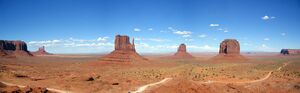
Monument Valley in southeastern Utah. This area was used to film many Hollywood Westerns.
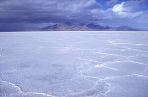
The otherworldly look of the Bonneville Salt Flats has been used in many movies and commercials.

Miscellaneous


انظر أيضا
المصادر
- ^ "Kings Peak Target". NGS data sheet. U.S. National Geodetic Survey.
- ^ أ ب "Elevations and Distances in the United States". United States Geological Survey. 2001. Archived from the original on November 9, 2013. Retrieved October 24, 2011.
- ^ Arave, Lynn (August 31, 2006). "Utah's basement—Beaver Dam Wash is state's lowest elevation". Deseret Morning News. Archived from the original on January 22, 2015.
- ^ "United States Census Quick Facts Utah". Retrieved January 9, 2025.
- ^ "Household Income in States and Metropolitan Areas: 2023" (PDF). Retrieved January 12, 2025.
- ^ أ ب "Utah's legislative session: We're officially Utahns now". Deseret News (in الإنجليزية). 2025-03-05. Retrieved 2025-03-07.
- ^ "SB0230". le.utah.gov. Retrieved 2025-03-08.
- ^ Utah (Online Dictionary ed.), Merriam-Webster, http://www.merriam-webster.com/dictionary/Utah
- ^ Utah Code, Title 63G, Chapter 1, Part 6, Section 601(10)
- ^ أ ب ت "Utah State Facts and Symbols". Utah.com (in الإنجليزية). Archived from the original on April 14, 2021. Retrieved April 26, 2021.
- ^ "Introduction: Urban Growth in Utah", QGET Databook, Quality Growth Efficiency Tools (QGET) Technical Committee, Governor's Office of Management & Budget, State of Utah, 1997, http://governor.utah.gov/dea/QGET/DataBook/4.htm, retrieved on November 4, 2014; see also: "Figures: Population Growth, 1940–2020 (slide 3)", QGET Databook, 1997, http://governor.utah.gov/DEA/QGET/DataBook/Figures/db3.html, retrieved on November 4, 2014
- ^ أ ب "Religious Landscape Study". May 11, 2015. Archived from the original on October 5, 2017. Retrieved October 5, 2017.
- ^ "American Religious Identification Survey (2001)". ISSSC. Archived from the original on November 3, 2011. Retrieved October 31, 2011.
- ^ أ ب Canham, Matt (أبريل 17, 2012). "Census: Share of Utah's Mormon residents holds steady". The Salt Lake Tribune. Archived from the original on نوفمبر 4, 2014.
- ^ Lindsey, Daryl (September 8, 2016). "Follow the profit: How Mormon culture made Utah a hotbed for multi-level marketers". Retrieved 28 March 2023.
- ^ The Fastest-Growing States in America (and Why They're Booming)—Jordan Weissmann Archived مايو 25, 2017 at the Wayback Machine. The Atlantic (December 22, 2012). Retrieved on July 12, 2013.
- ^ "Appendix E.—Ranking Tables" (PDF). State and Metropolitan Area Data Book: 2006. U.S. Census Bureau. December 22, 2008. Archived (PDF) from the original on March 25, 2009. Retrieved April 29, 2009.
- ^ Amy Joi O'Donoghue (February 14, 2022). "How bad is the Western drought? New study says worst in 1,200 years. You read that right". Deseret News. Retrieved February 18, 2022.
- ^ "If we want growth, we need water solutions". www.utahbusiness.com. May 11, 2022. Retrieved July 13, 2022.قالب:Title missing
- ^ أ ب "Utah Quick Facts". Archived from the original on April 25, 2021. Retrieved August 31, 2023.
- ^ "Utah: The Riddle Behind The Name". Deseret News. July 10, 1994. Archived from the original on October 13, 2018. Retrieved May 21, 2019.
- ^ Carvajal, Guillermo (January 13, 2014). "El desconocido origen español del nombre de ocho Estados de Norteamérica" [The unknown Spanish origin of the name of eight States of North America]. ABC. Archived from the original on June 3, 2016. Retrieved May 8, 2016.
- ^ "Native Americans in Utah". historytogo.utah.gov. Archived from the original on June 25, 2017. Retrieved July 9, 2017.
- ^ "Utah's American Indians". ilovehistory.utah.gov (in الإنجليزية). Archived from the original on June 25, 2017. Retrieved July 9, 2017.
- ^ Wheat, Carl I. "Mappig the American West 1540-1857". Proceedings of the American Antiquarian Society. 64 (1): 110.
- ^ Leonard J. Arrington and Davis Bitton: The Mormon Experience, page 22. Vintage/Random House, 1979.
- ^ Richard N. Ostling and Joan K. Ostling: Mormon America, page 38–39. HarperCollins, 2000.
- ^ William W. Slaughter and Michael Landon: Trail of Hope—The Story of the Mormon Trail. Shadow Mountain, 1997.
- ^ أ ب Arave, Lynn (January 5, 2007). "Tidbits of history — Unusual highlights of Salt Lake County". Deseret News. Retrieved May 6, 2020.
- ^ Negro Slaves in Utah by Jack Beller, Utah Historical Quarterly, vol. 2, no. 4, 1929, pp. 124–126
- ^ "Slavery in Utah Involved Blacks, Whites, Indians, and Mexicans". The History Blazer. No. April 1995. Utah State Historical Society. Retrieved May 6, 2020.
- ^ Arrington and Bitton, p. 118
- ^ William Clayton, edited by George D. Smith: An Intimate Chronicle: The Journals of William Clayton, p. 300. Signature Books, 1991.
- ^ Corporation of the President of The Church of Jesus Christ of Latter-day Saints: "Church History in the Fullness of Times". 1989.
- ^ Michael S. Durham: Desert between the Mountains, pages 162,163. University of Oklahoma Press, 1997.
- ^ John David Smith (1997). Dictionary of Afro-American Slavery. Bloomsbury Academic. ISBN 9780275957995.
- ^ Farmer, Jared (2008). On Zion's Mount: Mormons, Indians, and the American Landscape. Harvard University Press. ISBN 9780674027671.
- ^ Ravitz, Jessica (September 11, 2007). "LDS Church Apologizes for Mountain Meadows Massacre". The Salt Lake Tribune. Archived from the original on November 4, 2014.
- ^ "Ceremony at "Wedding of the Rails", May 10, 1869 at Promontory Point, Utah". World Digital Library. May 10, 1869. Archived from the original on October 18, 2013. Retrieved July 20, 2013.
- ^ "Rock Climbing Monument Valley in Northern Arizona". Mountain Project. Archived from the original on October 29, 2015. Retrieved November 7, 2015.
- ^ SKI Magazine's Top 30 Resorts for 2008–09[Usurped!]
- ^ "'Outside' magazine ranks the top ski resorts". USA Today. October 17, 2008. Archived from the original on May 26, 2010. Retrieved July 31, 2010.
- ^ "Official Utah State Parks website". Stateparks.utah.gov. Archived from the original on April 7, 2013. Retrieved November 7, 2015.
- ^ ANSS, "Magna 2020", Comprehensive Catalog, U.S. Geological Survey, retrieved March 18, 2020
- ^ أ ب "Elevations and Distances in the United States". United States Geological Survey. April 29, 2005. Archived from the original on November 2, 2006. Retrieved November 8, 2006.
- ^ Morgan, Dale L. (1947). The Great Salt Lake. Salt Lake City: University of Utah Press. p. 22. ISBN 978-0-87480-478-2.
- ^ Federal Land Ownership: Overview and Data. Congressional Research Service. February 21, 2020. Archived from the original. You must specify the date the archive was made using the
|archivedate=parameter. https://crsreports.congress.gov/product/pdf/R/R42346. Retrieved on July 2, 2025. - ^ "The state of Utah outdoor recreation vision" (PDF). January 2013. Archived (PDF) from the original on November 11, 2018. Retrieved October 13, 2018.
- ^ "Why is Utah so dry? - 2022". The Flat (in الإنجليزية الأمريكية). 2021-12-14. Retrieved 2022-06-10.
- ^ Steenburgh, Jim (November 14, 2014). Secrets of the Greatest Snow on Earth (1 ed.). Utah State University Press. ISBN 978-0874219500.
- ^ أ ب Gillies et al. (2012) http://journals.ametsoc.org/doi/abs/10.1175/JCLI-D-11-00084.1 Archived مايو 12, 2017 at the Wayback Machine, journals.ametsoc.org.
- ^ Fidel, Steve (July 6, 2007). "Utahns feeling hot, hot, hot". Deseret Morning News. Archived from the original on November 4, 2014.
- ^ "Utah Cold Weather Facts—Snow and Winter Storms". KSL-TV. Archived from the original on October 22, 2014. Retrieved October 19, 2014.
- ^ "WOODRUFF, UTAH (429595)". wrcc.dri.edu. Archived from the original on June 30, 2015. Retrieved October 19, 2014.
- ^ Annual Average Number of Tornadoes, 1953–2004 Archived أكتوبر 16, 2011 at the Wayback Machine. NOAA National Climatic Data Center. Retrieved March 20, 2008.
- ^ أ ب ت Brough, Clayton; Brown, Dan; James, David; Pope, Dan; Summy, Steve. "Salt Lake City Tornado - August 11, 1999". NOAA. Archived from the original on June 14, 2012.
- ^ Dunn, Larry; Alder, William; McClung, Tim (June 21, 1994). "Western Region Technical Attachment No. 94-20: The High Uinta Tornado" (PDF). NOAA. Retrieved October 7, 2021.
- ^ "Vertebrate Animals". Utah Division of Wildlife Resources. Archived from the original on May 2, 2017. Retrieved May 18, 2017.
- ^ "Insects and Mollusks". Utah Division of Wildlife Resources. Archived from the original on May 25, 2017. Retrieved May 18, 2017.
- ^ Stewart, Ron; Nielson, Allen (January 2011). "American Bison (Bison bison)". Utah Division of Wildlife Resources. p. 3. Archived from the original (PDF) on April 15, 2021. Retrieved December 7, 2020.
- ^ "American bison". Utah Division of Wildlife Resources. Archived from the original on July 19, 2020. Retrieved June 19, 2020.
- ^ "Elk or Wapati". Utah Division of Wildlife Resources. Archived from the original on July 19, 2020. Retrieved June 19, 2020.
- ^ أ ب ت ث ج ح خ د ذ ر ز س ش ص "Mammals of the Wasatch Front". Natural History Museum of Utah. August 29, 2012. Archived from the original on July 19, 2020. Retrieved July 19, 2020.
- ^ "Pronghorn". Utah Division of Wildlife Resources. Archived from the original on July 19, 2020. Retrieved June 19, 2020.
- ^ "California bighorn sheep". Utah Division of Wildlife Resources. Archived from the original on July 19, 2020. Retrieved June 19, 2020.
- ^ "Desert bighorn sheep". Utah Division of Wildlife Resources. Archived from the original on November 30, 2016. Retrieved June 19, 2020.
- ^ "Rocky Mountain bighorn sheep". Utah Division of Wildlife Resources. Archived from the original on July 19, 2020. Retrieved June 19, 2020.
- ^ "Nutriap". Utah Division of Wildlife Resources. Archived from the original on October 30, 2020. Retrieved March 15, 2021.
- ^ "Canada lynx". Utah Division of Wildlife Resources. Archived from the original on November 30, 2016. Retrieved June 19, 2020.
- ^ "Black-footed ferret". Utah Division of Wildlife Resources. Archived from the original on July 19, 2020. Retrieved June 19, 2020.
- ^ "Discover Utah". Loveland Living Planet Aquarium. Archived from the original on June 11, 2017. Retrieved May 21, 2017.
- ^ "Brown bear". Utah Division of Wildlife Resources. Archived from the original on July 19, 2020. Retrieved June 19, 2020.
- ^ "Gray wolf". Utah Division of Wildlife Resources. Archived from the original on July 19, 2020. Retrieved June 19, 2020.
- ^ Podmore, Zak (June 3, 2020). "A gray wolf is in Utah for the first time in years. The state is setting traps". Salt Lake Tribune. Archived from the original on July 19, 2020. Retrieved June 19, 2020.
- ^ "Birds of Utah". Utah Birds Records Committee. January 2020. Retrieved July 6, 2020.
- ^ "Auxiliary Lists". Utah Birds Records Committee. May 2017. Retrieved July 6, 2020.
- ^ "Utah State Bird". Utah.gov. Archived from the original on January 22, 2020. Retrieved August 11, 2014.
- ^ أ ب Ryser, Fred A. (1985). Birds of the Great Basin. Reno, NV, US: University of Nevada Press. p. 203. ISBN 0-87417-080-X. Retrieved August 11, 2014.[dead link]
- ^ "Larus philadelphia". Utah Division of Wildlife Resources. Archived from the original on December 13, 2016. Retrieved May 29, 2017.
- ^ "Turdus migratorius". Utah Division of Wildlife Resources. Archived from the original on December 13, 2016. Retrieved May 23, 2017.
- ^ "Leucosticte atrata". Utah Division of Wildlife Resources. Archived from the original on December 13, 2016. Retrieved May 29, 2017.
- ^ "Carpodacus cassinii". Utah Division of Wildlife Resources. Archived from the original on December 14, 2016. Retrieved June 24, 2017.
- ^ "Carduelis tristis". Utah Division of Wildlife Resources. Archived from the original on December 13, 2016. Retrieved May 23, 2017.
- ^ "Pica hudsonia". Utah Division of Wildlife Resources. Archived from the original on December 13, 2016. Retrieved May 29, 2017.
- ^ "Two Doves". ALPINE NATURE CENTER (in الإنجليزية). Retrieved 2023-09-29.
- ^ "Spizella arborea". Utah Division of Wildlife Resources. Archived from the original on December 13, 2016. Retrieved May 23, 2017.
- ^ "Spizella atrogularis". Utah Division of Wildlife Resources. Archived from the original on December 13, 2016. Retrieved May 29, 2017.
- ^ "Amphispiza bilineata". Utah Division of Wildlife Resources. Archived from the original on December 13, 2016. Retrieved May 29, 2017.
- ^ "Spizella breweri". Utah Division of Wildlife Resources. Archived from the original on December 13, 2016. Retrieved May 29, 2017.
- ^ "Spizella passerina". Utah Division of Wildlife Resources. Archived from the original on December 15, 2016. Retrieved June 24, 2017.
- ^ "Aechmophorus clarki". Utah Division of Wildlife Resources. Archived from the original on December 15, 2016. Retrieved June 24, 2017.
- ^ "Branta hutchinsii". Utah Division of Wildlife Resources. Archived from the original on December 14, 2016. Retrieved May 29, 2017.
- ^ "Branta canadensis". Utah Division of Wildlife Resources. Archived from the original on December 14, 2016. Retrieved May 29, 2017.
- ^ "Haliaeetus leucocephalus". Utah Division of Wildlife Resources. Archived from the original on December 13, 2016. Retrieved May 23, 2017.
- ^ "Callipepla californica". Utah Division of Wildlife Resources. Archived from the original on December 14, 2016. Retrieved May 29, 2017.
- ^ "Stellula calliope". Utah Division of Wildlife Resources. Archived from the original on December 14, 2016. Retrieved May 29, 2017.
- ^ "Archilochus alexandri". Utah Division of Wildlife Resources. Archived from the original on December 13, 2016. Retrieved May 29, 2017.
- ^ "Selasphorus platycercus". Utah Division of Wildlife Resources. Archived from the original on December 14, 2016. Retrieved May 29, 2017.
- ^ "Utah Pests Fact Sheet: Scorpions" (PDF). Utah State University Extension Service. Archived from the original on May 22, 2017. Retrieved May 22, 2017.
- ^ أ ب "Bugs of Utah". Natural History Museum of Utah. Natural History Museum of Utah. October 24, 2011. Archived from the original on July 1, 2017. Retrieved May 20, 2017.
- ^ "The Spiders of the Arid Southwest - Taxonomic Section - Entelegynae (page 3)". New Mexico State University College of Agricultural, Consumer and Environmental Sciences. Archived from the original on November 26, 2016. Retrieved May 22, 2017.
- ^ "Top 20 Arachnids". Utah State University Extension Service. Archived from the original on May 21, 2017. Retrieved May 22, 2017.
- ^ "Top 20 Arachnids". Utah State University Extension Office. Archived from the original on November 29, 2020. Retrieved March 15, 2021.
- ^ Crofts, Natalie (October 10, 2015). "5 of the most common spiders in Utah". KSL-TV. Archived from the original on March 16, 2021. Retrieved March 15, 2021.
- ^ Sagers, Larry A. (November 25, 1992). "Arachnophobia or not, Utahns should look upon spiders as friends". Deseret News. Archived from the original on March 16, 2021. Retrieved March 15, 2021.
- ^ "Murder Hornet Madness" (PDF). Utah State University Extension Office. 2020. p. 7. Archived (PDF) from the original on January 15, 2021. Retrieved March 15, 2021.
And finally, false reports of brown recluse spiders incite fear in Utah residents (only the desert recluse spider, found in Washington County, exists in Utah).
- ^ "Species Profile for Coral Pink Sand Dunes tiger beetle (Cicindela albissima)". United States Fish and Wildlife Service. Archived from the original on May 25, 2017. Retrieved May 18, 2017.
- ^ "Endangered and Threatened Wildlife and Plants; Proposed Threatened Status for Coral Pink Sand Dunes Tiger Beetle and Designation of Critical Habitat; Proposed Rule" (PDF). National Archives and Records Administration. October 2, 2012. Archived from the original (PDF) on May 25, 2017. Retrieved May 18, 2017.
- ^ "Endangered and Threatened Wildlife and Plants; Withdrawal of the Proposed Rule To List Coral Pink Sand Dunes Tiger Beetle and Designate Critical Habitat; Proposed Rule" (PDF). National Archives and Records Administration. October 2, 2013. Archived from the original (PDF) on May 6, 2017. Retrieved May 18, 2017.
- ^ "Grasshoppers". Utah State University Extension Services. Archived from the original on November 6, 2018. Retrieved May 22, 2017.
- ^ "Stink Bugs". Utah State University Extension Service. Archived from the original on November 6, 2018. Retrieved May 22, 2017.
- ^ "Cutworms". Utah State University Extension Services. Archived from the original on November 6, 2018. Retrieved May 22, 2017.
- ^ أ ب "List of Butterflies of Utah". The Butterfly Site. Archived from the original on June 15, 2017. Retrieved May 20, 2017.
- ^ "White-lined Sphinx Hyles lineata (Fabricius, 1775) | Butterflies and Moths of North America". www.butterfliesandmoths.org (in الإنجليزية). Archived from the original on August 21, 2017. Retrieved November 14, 2017.
- ^ England, Katie (June 10, 2018). "Spanish Fork resident shows off fireflies for community". The Daily Herald. Archived from the original on June 12, 2018. Retrieved March 15, 2021.
- ^ African bees found in Utah for the first time Archived سبتمبر 12, 2016 at the Wayback Machine. Associated Press. February 12, 2009
- ^ "Utah Department of Agriculture and Food". Ag.utah.gov. Archived from the original on October 20, 2010. Retrieved October 19, 2010.
- ^ Wright, Becky (May 18, 2017). "Killer bees now documented in 8 Utah counties". KSL-TV. Archived from the original on May 20, 2017. Retrieved May 18, 2017.
- ^ أ ب Mitton, Jeffry B.; Grant, Michael C. (1996). "Genetic Variation and the Natural History of Quaking Aspen". BioScience. 46 (1): 25–31. doi:10.2307/1312652. ISSN 0006-3568. JSTOR 1312652.
- ^ أ ب Mock, K. E.; Rowe, C. A.; Hooten, M. B.; Dewoody, J.; Hipkins, V. D. (November 2008). "Clonal dynamics in western North American aspen (Populus tremuloides)". Molecular Ecology (in الإنجليزية). 17 (22): 4827–4844. Bibcode:2008MolEc..17.4827M. doi:10.1111/j.1365-294X.2008.03963.x. PMID 19140975. S2CID 1425039.
- ^ "Plants". Utah Division of Wildlife Resources. Archived from the original on May 25, 2017. Retrieved May 18, 2017.
- ^ Maffly, Brian (May 7, 2018). "How a 'waterwise' ornamental plant has taken over Wasatch foothills". Salt Lake Tribune. Archived from the original on July 21, 2020. Retrieved July 21, 2020.
- ^ University of Utah Health Office of Public Affairs (July 1, 2014). "Protect Yourself From Poisonous Plants". Archived from the original on October 3, 2016. Retrieved March 15, 2021.
- ^ "State of Utah Noxious Weed List". Utah Department of Agriculture and Food. June 6, 2019. Archived from the original on January 22, 2020. Retrieved July 21, 2020.
- ^ "QuickFacts Utah; UNITED STATES". 2019 Population Estimates. United States Census Bureau, Population Division. February 26, 2019. Archived from the original on January 11, 2019. Retrieved February 26, 2019.
- ^ "Population and Population Centers by State". United States Census Bureau. 2000. Archived from the original on September 18, 2008. Retrieved December 6, 2008.
- ^ Bulkeley, Deborah (September 22, 2005). "St. George growth 2nd fastest in US". Deseret Morning News. Archived from the original on November 4, 2014.
- ^ "2007-2022 PIT Counts by State".
- ^ "The 2022 Annual Homelessness Assessment Report (AHAR) to Congress" (PDF).
- ^ "New Americans in Utah" (PDF). www.americanimmigrationcouncil.org.
- ^ "Immigrants in Utah". May 2015.
- ^ "Teenage Abortion and Pregnancy Statistics by State, 1992". United States: AGI. مايو 30, 1997. Archived from the original on مارس 2, 2006. Retrieved يوليو 31, 2010.
- ^ "Contraception Counts: State-by-State Information". US: AGI. Archived from the original on May 17, 2008. Retrieved July 31, 2010.
- ^ أ ب "Sampling of Latter-day Saint/Utah Demographics and Social Statistics from National Sources". Adherents.com. Archived from the original on May 8, 2010. Retrieved July 31, 2010.
{{cite web}}: CS1 maint: unfit URL (link) - ^ "Fourth year Hawai'i no wellbeing last". Gallup. Archived from the original on July 30, 2013. Retrieved August 15, 2013.
- ^ "Study Finds Utah Leads Nation in Antidepressant Use". Los Angeles Times. February 20, 2002. Archived from the original on October 21, 2013. Retrieved July 12, 2013.
- ^ O Gonzalez; JT Berry; et al. (October 1, 2010). "Current Depression Among Adults, United States, 2006 and 2008". Morbidity and Mortality Weekly Report. 59 (38): 1229–1235. PMID 20881934. Archived from the original on September 2, 2017. Retrieved September 17, 2017.
- ^ "Percent of Babies Born to Unmarried Mothers by State". U.S. Department of Health & Human Services. February 24, 2022. Retrieved September 21, 2024.
- ^ "QuickFacts: Utah". Census.gov. United States Census Bureau. Retrieved December 21, 2024.
- ^ "Historical Population Change Data (1910–2020)". Census.gov. United States Census Bureau. Archived from the original on April 29, 2021. Retrieved May 1, 2021.
- ^ "Race and Ethnicity in the United States: 2010 Census and 2020 Census". census.gov. United States Census Bureau. August 12, 2021. Retrieved 2021-09-26.
- ^ أ ب Gibson, Campbell; Jung, Kay (September 2002). "Historical Census Statistics on Population Totals By Race, 1790 to 1990, and By Hispanic Origin, 1970 to 1990, For The United States, Regions, Divisions, and States". United States Census Bureau. Section: "Utah—Race and Hispanic Origin: 1850 to 1990". Archived from the original on July 25, 2008.
- ^ "Population of Utah: Census 2010 and 2000 Interactive Map, Demographics, Statistics, Quick Facts". Archived from the original on March 23, 2016.
- ^ "2010 Census Data". United States Census Bureau. census.gov. Retrieved November 7, 2015. Search "Utah" in "2010 Census Demographic Profiles" (via U.S. Census website), or in "2010 Census Population Profiles Maps—Population Profiles Archived يوليو 23, 2017 at the Wayback Machine".
- ^ Exner, Rich (June 3, 2012). "Americans under age 1 now mostly minorities, but not in Ohio: Statistical Snapshot". The Plain Dealer. Archived from the original on July 14, 2016. Retrieved August 16, 2012.
- ^ Canham, Matt (July 16, 2017). "Salt Lake County is becoming less Mormon—Utah County is headed in the other direction". Retrieved February 12, 2020.
- ^ Canham, Matt (November 18, 2007). "Utah less LDS than ever". The Salt Lake Tribune. Retrieved February 12, 2020.
- ^ "Salt Lake County is now minority Mormon, and the impacts are far reaching". The Salt Lake Tribune (in الإنجليزية الأمريكية). Retrieved December 29, 2019.
- ^ "Utah sees Latter-day Saint slowdown and membership numbers drop in Salt Lake County". The Salt Lake Tribune (in الإنجليزية الأمريكية). Retrieved April 3, 2020.
- ^ "Facts and Statistics USA-Utah". Mormon newsroom. LDS. Archived from the original on June 30, 2019. Retrieved May 8, 2012.
- ^ خطأ استشهاد: وسم
<ref>غير صحيح؛ لا نص تم توفيره للمراجع المسماةneutrality - ^ Campbell, David E; Monson, J Quin. "Dry Kindling: A Political Profile of American Mormons" (PDF). From Pews to Polling Places: Faith and Politics in the American Religious Mosaic. Georgetown University Press. Archived from the original (PDF) on October 15, 2012.
- ^ أ ب Davidson, Lee (August 19, 2008). "Utah's birthrate highest in US". Deseret News. Archived from the original on November 4, 2014.
- ^ Davidson, Lee (January 28, 2008). "Utah Voters Shun Labels". Deseret Morning News. Archived from the original on November 4, 2014.
- ^ "The Association of Religion Data Archives | State Membership Report". www.thearda.com. Archived from the original on February 9, 2014. Retrieved December 12, 2013.
- ^ "State of the States". Gallup. Archived from the original on August 17, 2016. Retrieved July 6, 2016.
- ^ "Frequent Church Attendance Highest in Utah, Lowest in Vermont". Gallup. February 17, 2015. Archived from the original on August 17, 2016. Retrieved July 6, 2016.
- ^ أ ب Cragun, Ryan T.; Gull, Bethany; Phillips, Rick (2023). "Mormons Are No Longer a Majority in Utah: Causes, Consequences, and Implications for the Sociology of Religion". Journal of Religion and Demography. 10 (1–2): 162–184. doi:10.1163/2589742x-bja10019. ISSN 2589-7411. S2CID 267601458.
- ^ "Utah Code Section". le.utah.gov. Retrieved 9 February 2023.
- ^ Bowie, David (February 1, 2008). "Acoustic Characteristics of Utah's Card-Cord Merger". American Speech (in الإنجليزية). 83 (1): 35–61. doi:10.1215/00031283-2008-002. ISSN 0003-1283.
- ^ Sterling, Terry (July 23, 2012). "Utah: An Economy Powered by Multilingual Missionaries". The National Journal. Archived from the original on April 15, 2013.
- ^ " "Utah—Languages". city-data.com. Retrieved November 7, 2015.
- ^ Lee, Jasen (January 13, 2013). "Salt Lake metro becoming tech hub". Deseret News. Archived from the original on November 4, 2014.
- ^ "SAGDP1 State annual gross domestic product (GDP) summary". U.S. Bureau of Economic Analysis. March 28, 2025. Retrieved July 17, 2025.
- ^ Badenhausen, Kurt (October 13, 2010). "The Best States For Business And Careers". Forbes. Archived from the original on October 4, 2017. Retrieved September 17, 2017.
- ^ Dokoupil, Tony (November 8, 2010). "How Utah Became an Economic Zion". Newsweek. Archived from the original on November 5, 2014. Retrieved November 4, 2014.
- ^ Economy at a Glance: Utah, Bureau of Labor Statistics, United States Department of Labor, http://www.bls.gov/eag/eag.ut.htm, retrieved on November 4, 2014
- ^ "United States Small Business Friendliness: 2014". Thumbtack.com. Thumbtack and the Ewing Marion Kauffman Foundation. Archived from the original on November 4, 2014. Retrieved November 4, 2014.
- ^ Utah oil & gas production[Usurped!] (map) as found at Utah.gov
- ^ "Volunteering in Utah—Volunteering in America". Volunteeringinamerica.gov. August 9, 2011. Retrieved November 15, 2011.
- ^ "Utah Income Tax - Tax Rates". utah.gov (Utah state official website). Retrieved 2025-04-14.
- ^ Utah Sales and Use Tax Rates Archived أكتوبر 16, 2007 at the Wayback Machine, from utah.gov (the State of Utah's official website). Retrieved March 20, 2008.
- ^ Gorrell, Mike (October 5, 2010). "Deer Valley maintains Ski ranking through downturn". The Salt Lake Tribune. Archived from the original on November 4, 2014.
- ^ "| SKI Magazine". Archived from the original on September 24, 2011. Retrieved September 17, 2009.
{{cite web}}: CS1 maint: unfit URL (link) "Ski Magazine top 10 list: Reader Resort Survey - ^ Falk, Aaron (March 12, 2009). "Temple Square ranks 16th in visitors". Deseret News. Archived from the original on November 4, 2014.
- ^ "Visit Utah". Office of Tourism. Archived from the original on November 7, 2015. Retrieved November 7, 2015.
- ^ أ ب Utah Department of Community and Culture, Mining Heritage Alliance, Highlights Archived يناير 17, 2013 at the Wayback Machine http://finance.utah.gov/highlights.html Archived يناير 17, 2013 at the Wayback Machine as found at Utah.gov http://finance.utah.gov/highlights.html Archived يناير 17, 2013 at the Wayback Machine
- ^ "Utah - State Energy Profile - Analysis". U.S. Energy Information Administration. Retrieved February 28, 2021.
- ^ "Renewable Energy Technical Potential". Nrel.gov. October 17, 2013. Archived from the original on September 15, 2012. Retrieved December 31, 2013.
- ^ Stoddard, Patsy (January 24, 2017). "Update on the Nuclear Power Plant for Green River". Emery County Progress. Castle Dale, Utah. Archived from the original on February 11, 2017. Retrieved February 9, 2017.
- ^ "About UAMPS". Utah Associated Municipal Power Systems. Retrieved 12 November 2023.
- ^ U.S. Department of Transportation Bureau of Statistics Archived أكتوبر 12, 2008 at the Wayback Machine Retrieved on March 5, 2008.
- ^ "Resident Population Data: 2020 Census" (PDF). US Census Bureau. Retrieved January 18, 2022.
- ^ "QuickFacts: Sandy city, Utah; Orem city, Utah; West Jordan city, Utah; Provo city, Utah; West Valley City city, Utah; Salt Lake City city, Utah". United States Census Bureau. Archived from the original on September 22, 2018. Retrieved September 24, 2018.
- ^ "Dixie State University is changing its name, but what about other 'Dixie' schools in Utah?". ABC4 Utah (in الإنجليزية الأمريكية). 2021-11-15. Archived from the original on November 16, 2021. Retrieved 2021-11-16.
- ^ Speckman, Stephen; Smeath, Doug (November 22, 2006). "What's in a name? Bit of a hassle". Deseret Morning News. Archived from the original on November 4, 2014.
- ^ Lazerus, Mark (December 23, 2024). "Inside Utah Hockey Club's unprecedented five-month scramble to NHL opening night". The New York Times.
- ^ Edward, James (November 23, 2009). "Real Salt Lake wins dramatic MLS Cup on penalty kicks". Deseret News. Archived from the original on May 25, 2017. Retrieved May 1, 2017.
- ^ "Real Salt Lake announce that new USL PRO team will be called Real Monarchs". MLSsoccer.com. September 10, 2014. Archived from the original on September 11, 2014. Retrieved September 11, 2014.
- ^ "Zions Bank Real Academy new home for Real Salt Lake development pyramid". Real Monarchs. May 24, 2017. Archived from the original on November 17, 2017. Retrieved November 17, 2017.
- ^ Linehan, Meg (March 11, 2023). "Utah Royals return to NWSL for 'new era' with different investors". The New York Times (in الإنجليزية الأمريكية). ISSN 0362-4331. Retrieved 2025-01-23.
- ^ "Utah Royals FC unveils name, identity for 2018 NWSL season" (Press release). Real Salt Lake. December 1, 2017. Archived from the original on December 2, 2017. Retrieved December 5, 2017.
- ^ "Kansas City Returns to the NWSL as Expansion Team in 2021". NWSL. December 7, 2020. Archived from the original on November 22, 2021. Retrieved 7 December 2020.
- ^ Lee, Jasen (February 8, 2012). "Economic impact of 2002 Olympics still felt". KSL-TV. Archived from the original on May 25, 2017. Retrieved May 18, 2017.
- ^ أ ب "Utah Youth Enjoying 7s Season, Continuing To Grow" Archived أكتوبر 14, 2014 at the Wayback Machine, This Is American Rugby, October 8, 2014.
- ^ أ ب "'Forever Strong' inspired change, growth for Utah rugby teams". KSL. March 8, 2013. Archived from the original on May 10, 2013. Retrieved March 12, 2013.
- ^ "Home". Utah Warriors Rugby. Archived from the original on February 2, 2019. Retrieved February 1, 2019.
- ^ أ ب "Filming Locations". Internet Movie Database (IMDb). Archived from the original on May 25, 2017. Retrieved July 21, 2018.
- ^ "Real World Architecture and Locations in The Last of Us". Reality is a Game. July 30, 2013. Archived from the original on November 27, 2018. Retrieved September 24, 2018.
- ^ Miller, Nick (2024-02-02). "Reely Big: The Largest Film Festivals in the World". Discovery UK (in الإنجليزية الأمريكية). Retrieved 2025-01-23.
وصلات خارجية
![]() تعريفات قاموسية في ويكاموس
تعريفات قاموسية في ويكاموس
![]() كتب من معرفة الكتب
كتب من معرفة الكتب
![]() اقتباسات من معرفة الاقتباس
اقتباسات من معرفة الاقتباس
![]() نصوص مصدرية من معرفة المصادر
نصوص مصدرية من معرفة المصادر
![]() صور و ملفات صوتية من كومونز
صور و ملفات صوتية من كومونز
![]() أخبار من معرفة الأخبار.
أخبار من معرفة الأخبار.
General
- يوتا at the Open Directory Project
Government
- State of Utah official Web site
- Full text of the Utah state constitution
- Energy Data & Statistics for Utah
- Utah Department of Environmental Quality - information of pollution in Utah.
- Utah Health Story Bank - database site of health issue's stories by the Utah Department of Health.
Maps and Demographics
- Utah State Facts
- USGS real-time, geographic, and other scientific resources of Utah
- Utah Earthquake Information - information of earthquake in Utah.
- Utah QuickFacts from the U.S. Census Bureau
Tourism and Recreation
- Utah Office of Tourism (requires Flash)
- Utah Arts Council
- Utah History to go
- Utah History for kids
- Wilderness Utah- Hiking and Backpacking in Utah
- Utah Fly Fishing - Fly Fishing information in Utah
Other
- Utah State Chamber of Commerce
- Utah Newspapers - Most comprehensive directory.
- Utah Business Directory
معلومات ذات صلة

|
وايومنگ | آيداهو |
| |
| كولورادو | Nevada | |||
| نيو مكسيكو | Arizona |
| سبقه Wyoming |
List of U.S. states by date of statehood Admitted on January 4, 1896 (45th) |
تبعه Oklahoma |
.jpg&filetimestamp=20250911014908)
| International | |
|---|---|
| National | |
| هذه بذرة مقالة عن هذا المقال عن موضوع متعلق بجغرافية قارة أمريكا الشمالية، يحتاج للنمو والتطوير. هو أشبه بالبذرة التي تحتاج العناية، والجهد. فلا تبخل بهما. تحتاج للنمو والتحسين، ساهم في إثرائها بالمشاركة في تحريرها. |
خطأ استشهاد: وسوم <ref> موجودة لمجموعة اسمها "lower-alpha"، ولكن لم يتم العثور على وسم <references group="lower-alpha"/>
- CS1: Julian–Gregorian uncertainty
- Articles using Cite anss
- CS1 الإنجليزية الأمريكية-language sources (en-us)
- Articles with dead external links from February 2023
- CS1 maint: unfit URL
- Pages using gadget WikiMiniAtlas
- Short description is different from Wikidata
- Pages using infobox settlement with no coordinates
- Articles containing Ute-Southern Paiute-language text
- Articles with text in Apache languages
- Articles containing إسپانية-language text
- Articles with hatnote templates targeting a nonexistent page
- مقالات فيها عبارات متقادمة منذ يونيو 2020
- جميع المقالات التي فيها عبارات متقادمة
- مقالات فيها عبارات متقادمة منذ 2018
- مقالات فيها عبارات متقادمة منذ 2012
- مقالات فيها عبارات متقادمة منذ 2014
- مقالات فيها عبارات متقادمة منذ 2010
- مقالات فيها عبارات متقادمة منذ September 2014
- Articles with unsourced statements from August 2012
- Pages with empty portal template
- Coordinates on Wikidata
- Utah
- Former Spanish colonies
- States and territories established in 1896
- States of the United States
- غرب الولايات المتحدة
- 1896 establishments in the United States
- Contiguous United States
- مستعمرات إسپانية سابقة
- دول وأراضي تأسست في 1896
- بذرة جغرافيا امريكا الشمالية
- ولايات أمريكية