محافظة إدرنه
إدرنه
Edirne ili | |
|---|---|
|
Yukarıdan aşağıya, soldan sağa: Selimiye Camii, Meriç Köprüsü, Ali Paşa Çarşısı, Lozan Anıtı, Trakya Üniversitesi (eski Tren Garı), Eski Cami, Belediye Binası, Tarihî Lokomotif | |
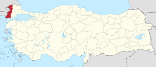
 موقع محافظة إدرنه في تركيا | |
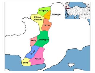
 أقضية محافظة إدرنه | |
| البلد | تركيا |
| المنطقة | مرمرة |
| العاصمة | إدرنه |
| المساحة | |
| • الإجمالي | 6٬279 كم² (2٬424 ميل²) |
| التعداد (2010-12-31)[1] | |
| • الإجمالي | 390٬428 |
| • الكثافة | 62/km2 (160/sq mi) |
| مفتاح الهاتف | 0284 |
| لوحة السيارة | 22 |
| الموقع الإلكتروني | إدرنه.gov.tr |
محافظة إدرنه Edirne Province (تركية: Edirne ili)، هي إحدى محافظات تركيا في تراقيا الشرقية، تقع في منطقة مرمرة على الحدود مع اليونان وبلغاريا. عاصمتها مدينة إدرنه. Its area is 6,145 km2,[2] and its population is 414,714 (2022).[3] Edirne Province is bordered by Tekirdağ Province and Kırklareli Province to the east, and the Gallipoli peninsula of Çanakkale Province to the south-east. It shares international borders with Bulgaria (Haskovo and Yambol Provinces) to the north and Greece (Eastern Macedonia and Thrace) to the west. Edirne is the capital of the province, and the largest city. It is the only province of Turkey that borders Greece.
التاريخ
Edirne, capital of the province, is notable for serving as the third capital of the Ottoman Empire from 1363 to 1453.
Edirne province was included in the Second Inspectorate General which was created on the 19 February 1934 and extended over the provinces of Edirne, Çanakkale, Kırklareli, Tekirdağ.[4] It was ruled by an Inspector General, who had wide-ranging authorities over civilian, military and educational matters.[5] The office of the Inspectorate-General was abandoned in 1948[6] but the legal framework of the Inspectorate-Generals was only abolished in 1952, under the Government of the Democrat Party.[7]
Until the reign of Selim I, there were remnant populations of so-called Tengri Turks in the province of Edirne who adhered to the ancient beliefs of Tengrism. It is assumed that it was a group of nomadic Yörüks.[8]
السكان
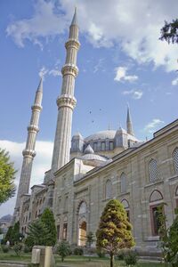
 مسجد سليمية في إدرنه |
| السنة | تعداد | ±% p.a. |
|---|---|---|
| 1927 | 150٬840 | — |
| 1940 | 251٬373 | +4.01% |
| 1950 | 221٬268 | −1.27% |
| 1960 | 276٬479 | +2.25% |
| 1970 | 316٬425 | +1.36% |
| 1980 | 363٬286 | +1.39% |
| 1990 | 404٬599 | +1.08% |
| 2000 | 402٬606 | −0.05% |
| 2010 | 390٬428 | −0.31% |
| 2018 | 411٬528 | +0.66% |
| source:[9][10] | ||
المقاطعات
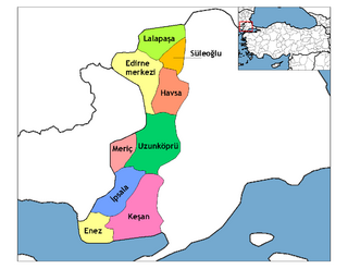
تنقسم محافظة إدرنه إلى 9 مقاطعات (المقاطعة العاصمة بالخط العريض):
معرض صور
Church of Saint John the Baptist in Uzunköprü.
انظر أيضاً
المصادر
- ^ Turkish Statistical Institute, MS Excel document – Population of province/district centers and towns/villages and population growth rate by provinces
- ^ "İl ve İlçe Yüz ölçümleri". General Directorate of Mapping. Retrieved 19 September 2023.
- ^ "Address-based population registration system (ADNKS) results dated 31 December 2022, Favorite Reports" (XLS) (in الإنجليزية). TÜİK. Retrieved 19 September 2023.
- ^ Cagaptay, Soner (2006). Islam, Secularism, and Nationalism in Modern Turkey; Who is a Turk. Routledge. p. 47.
- ^ Pekesen, Berna (16 December 2019). Florian, Riedler; Kravietz, Birgit (eds.). The Heritage of Edirne in Ottoman and Turkish Times: Continuities, Disruptions and Reconnections (in الإنجليزية). Walter de Gruyter GmbH & Co KG. pp. 423–424. ISBN 978-3-11-063908-7.
- ^ Bayir, Derya (2016-04-22). Minorities and Nationalism in Turkish Law (in الإنجليزية). Routledge. p. 141. ISBN 978-1-317-09579-8.
- ^ Bozarslan, Hamit (2008-04-17). Fleet, Kate; Faroqhi, Suraiya; Kasaba, Reşat; Kunt, I. Metin (eds.). The Cambridge History of Turkey (in الإنجليزية). Cambridge University Press. p. 343. ISBN 978-0-521-62096-3.
- ^ "Osmanlı'da Tengri İnancının Kalıntıları ve Kendi Kanını Akıtan Türkler". April 2020.
- ^ Genel Nüfus Sayımları
- ^ tuik


