خورگو Khorgo
| Khorgo | |
|---|---|
| منغولية: Хорго | |
IUCN category II (national park) | |
 المنظر من حافة خورگو | |
 موقع البركان | |
| الإحداثيات | 48°11′05″N 99°51′19″E / 48.1847°N 99.8554°E |
| تأسست | 1965 |
| الهيئة الحاكمة | وزارة البيئة والتنمية الخضراء |
خورگو ( Khorgo ؛ منغولية: Хорго) هو بركان خامد في Taryatu-Chulutu حقل بركاني في Tariat District، محافظة آرخانگاي، منغوليا. Khorgo lies east of the Terkhiin Tsagaan lake and together they are the core of the Khorgo-Terkhiin Tsagaan Nuur National Park. The surrounding park has been a protected area since 1965 as a nature reserve, becoming fully protected in 1994/1997[أ] as a national park, in order to safeguard the scenery and the endangered flora and fauna of the area.[1][2]
Khorgo is situated at an altitude of 2،210 m (7،250 ft), with a base diameter of 1،200 m (3،900 ft) and a height of 120 m (390 ft). On top of the cone there is a crater 180 m (590 ft) wide.[3] A notable geological feature is the solidified lava bubbles, which the locals have named "basalt yurts".[4]<[2] Around 8,000 years ago during the Holocene, the Khorgo cinder cone erupted, with lava flooding the valley below, forming a lava dam which created the Terkhiin Tsagaan lake.[3]
The valleys surrounding the volcano are today populated by small forests of Siberian larch with a variety of flora and fauna. This includes wild goats, wild boars, various species of bird such as the ruddy shelduck and various species of deer such as red deer and Siberian deer.[1]
There is no lake in the crater of Khorgo, but clouds of steam are sometimes emitted from crevices in the walls of the crater, forming ice in the winter. These ice forms are described as appearing from a distance to be "like large flocks of sheep scattered on the mountain".[1][5]
معرض
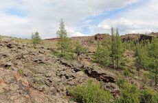
Exterior of the volcano
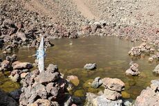
داخل البركان
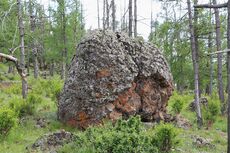
صخرة بركانية من البركان
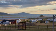
مخيم سياحي من اليورتات بين بركان خورگو وبحيرة ترخين تساگان، أرخانگاي، منغوليا، 26 يوليو 2025


المراجع
- ^ أ ب ت "Khorgo Extinct Volcano". Amicus Travel Mongolia (in الإنجليزية الأمريكية). Retrieved 2023-11-28.
- ^ أ ب Ховор, гайхамшигт "Хоргын тогоо"
- ^ أ ب Devyatkin, Ye. V.; Smelov, S. B. (1980). "Position of basalts in the Cenozoic sedimentary sequence of Mongolia". International Geology Review (in الإنجليزية). 22 (3): 307–317. Bibcode:1980IGRv...22..307D. doi:10.1080/00206818209466888. ISSN 0020-6814. Retrieved 28 November 2023.
- ^ Kara György (1979). Mongólia. Panoráma. p. 214. ISBN 963243062X. (hungarian)
- ^ "Khorgo terkhiin tsagaan nuur national park". Discover Mongolia Travel (in الإنجليزية). Retrieved 2023-11-28.
ملاحظات
- ^ Variously described as 1994 and 1997 on two different sources, please see nearest reference.