آسو Assu, Rio Grande do Norte
آسو
Assu | |
|---|---|
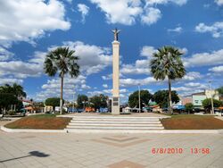
 ميدان القديس يوحنا المعمداني ونصب المسيح الملك في وسط الصورة | |
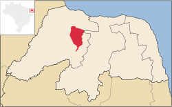
 الموقع في ولاية ريو گراندي دو نورتي | |
| الإحداثيات: 5°34′37″S 36°54′32″W / 5.57694°S 36.90889°W | |
| البلد | Brazil |
| المنطقة | الشمالي الشرقي |
| الولاية | ريو گراندي دو نورتي |
| المساحة | |
| • الإجمالي | 1٬303 كم² (503 ميل²) |
| التعداد (2020 [1]) | |
| • الإجمالي | 58٬384 |
| • الكثافة | 45/km2 (120/sq mi) |
| منطقة التوقيت | UTC-03:00 (BRT) |
آسو ( Açu أو Assu ) هي بلدية (município) in the state of Rio Grande do Norte in Brazil. The population is 58,384 (2020 est.) in an area of 1303 km².[2]
The municipality contains the Açu National Forest, a 218 هكتار (540 acre) sustainable use conservation unit that was originally established as a forest park in 1950.[3] The Barragem Armando Ribeiro Gonçalves, a reservoir on the Piranhas River, is partly located in the municipality.
المراجع
- ^ IBGE 2020
- ^ Instituto Brasileiro de Geografia e Estatística
- ^ (in Portuguese)FLONA Açu, ISA: Instituto Socioambiental, https://uc.socioambiental.org/uc/581585, retrieved on 2016-06-01
وصلات خارجية
?


