أريليى
Arilje
Ариље | |
|---|---|
Town and municipality | |
   Clockwise, from top: Panorama of Arilje, town center promenade, 13th century Saint Achillius Church | |
 Coat of arms | |
 موقع بلدية أريليى في صربيا | |
| الإحداثيات: 43°45′N 20°06′E / 43.750°N 20.100°E | |
| البلد | |
| المنطقة | شومادية وغرب صربيا |
| المحافظة | زلاتيبور |
| وضع بلدة | 1880 |
| أسسها | Milan Obrenović IV |
| التجمعات | 22 |
| الحكومة | |
| • Mayor | Zoran Todorović (SNS) |
| المساحة | |
| • Town | 3٫94 كم² (1٫52 ميل²) |
| • Municipality | 349٫06 كم² (134٫77 ميل²) |
| المنسوب | 350 m (1٬150 ft) |
| أعلى منسوب | 1٬328 m (4٬357 ft) |
| التعداد (2011 census)[2] | |
| • Town | 6٬763 |
| • كثافة Town | 1٬700/km2 (4٬400/sq mi) |
| • Municipality | 18٬792 |
| • كثافة Municipality | 54/km2 (140/sq mi) |
| منطقة التوقيت | UTC+1 (CET) |
| • الصيف (التوقيت الصيفي) | UTC+2 (CEST) |
| Postal code | 31230 |
| Area code | +381(0)31 |
| Car plates | UE |
| الموقع الإلكتروني | www |
أريليى (سيريلية صربية: Ариље, تـُنطق [ǎriːʎɛ]؛ إنگليزية: Arilje) هي بلدة وبلدية في محافظة زلاتيبور في جنوب غرب صربيا. يبلغ عدد سكانها حوالي 7064 نسمة.
الديمغرافيا
| السنة | تعداد | ±% p.a. |
|---|---|---|
| 1948 | 20٬316 | — |
| 1953 | 20٬882 | +0.55% |
| 1961 | 20٬001 | −0.54% |
| 1971 | 19٬581 | −0.21% |
| 1981 | 20٬111 | +0.27% |
| 1991 | 20٬335 | +0.11% |
| 2002 | 19٬784 | −0.25% |
| 2011 | 18٬792 | −0.57% |
| Source: [3] | ||
According to the 2011 census results, the municipality of Arilje has a population of 18,792 inhabitants.
الجماعات العرقية
The ethnic composition of the municipality:
| الجماعة العرقية | التعداد |
|---|---|
| Serbs | 18,407 |
| Roma | 120 |
| Montenegrins | 22 |
| Muslims | 10 |
| Macedonians | 9 |
| Bulgarians | 8 |
| Croats | 8 |
| Others | 208 |
| Total | 18,792 |
المناخ
أريليى has a humid continental climate (Köppen climate classification: Dfb), that's very close to an oceanic climate (Köppen climate classification: Cfb).
| بيانات المناخ لـ أريليى | |||||||||||||
|---|---|---|---|---|---|---|---|---|---|---|---|---|---|
| الشهر | ينا | فب | مار | أبر | ماي | يون | يول | أغس | سبت | أكت | نوف | ديس | السنة |
| متوسط القصوى اليومية °س (°ف) | 3.6 (38.5) |
6.5 (43.7) |
11.9 (53.4) |
15.9 (60.6) |
20.6 (69.1) |
24.3 (75.7) |
26.4 (79.5) |
26.7 (80.1) |
23.1 (73.6) |
17.5 (63.5) |
9.9 (49.8) |
5.3 (41.5) |
16.0 (60.7) |
| المتوسط اليومي °س (°ف) | 0.0 (32.0) |
2.4 (36.3) |
6.7 (44.1) |
10.5 (50.9) |
15.1 (59.2) |
18.7 (65.7) |
20.4 (68.7) |
20.4 (68.7) |
16.9 (62.4) |
12.1 (53.8) |
6.0 (42.8) |
2.0 (35.6) |
10.9 (51.7) |
| متوسط الدنيا اليومية °س (°ف) | −3.6 (25.5) |
−1.7 (28.9) |
1.6 (34.9) |
5.2 (41.4) |
9.7 (49.5) |
13.1 (55.6) |
14.5 (58.1) |
14.2 (57.6) |
10.8 (51.4) |
6.8 (44.2) |
2.1 (35.8) |
−1.3 (29.7) |
5.9 (42.7) |
| متوسط تساقط الأمطار mm (inches) | 64 (2.5) |
59 (2.3) |
60 (2.4) |
70 (2.8) |
91 (3.6) |
87 (3.4) |
77 (3.0) |
64 (2.5) |
67 (2.6) |
71 (2.8) |
83 (3.3) |
78 (3.1) |
871 (34.3) |
| Source: Climate-Data.org [4] | |||||||||||||
معرض صور

ممشى وسط البلدة

Church of St. Achillius

Church of St. Achillius
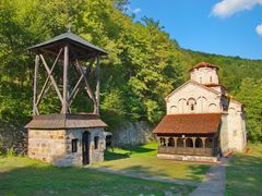
Klisura Monastery
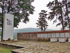
Monument in town park
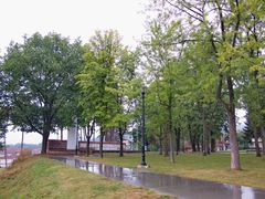
Town park
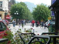
Town center street
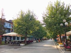
ممشى وسط البلدة
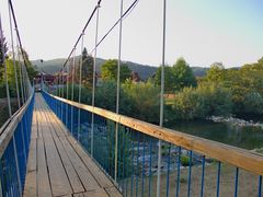
جسر مشاة على نهر موراڤيتسا
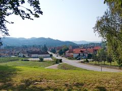
منظر جزء من البلدة


المراجع
- ^ قالب:Serbian municipalities 2006
- ^ قالب:Serbian census 2011
- ^ "2011 Census of Population, Households and Dwellings in the Republic of Serbia" (PDF). stat.gov.rs. Statistical Office of the Republic of Serbia. Archived from the original (PDF) on 14 July 2014. Retrieved 11 January 2017.
- ^ "Climate: Arilje, Serbia". Climate-Data.org. Retrieved 14 February 2018.
وصلات خارجية


This article may include material from Wikimedia licensed under CC BY-SA 4.0. Please comply with the license terms.