ترير
ترير
Tréier (لوكسمبورگية) | |
|---|---|
Trier skyline Trier market place | |
 Flag  Coat of arms | |
Location of ترير خطأ: الوظيفة "main" غير موجودة. | |
 ترير  ترير | |
| الإحداثيات: 49°45′24″N 06°38′29″E / 49.75667°N 6.64139°E | |
| البلد | ألمانيا |
| ولاية | راينلاند-پالاتينات |
| المقاطعة | المقاطعة الحضرية |
| تأسست | 17 BC[1] |
| الحكومة | |
| • العمدة اللورد (2023–2031) | Wolfram Leibe[2] (SPD) |
| المساحة | |
| • الإجمالي | 117٫06 كم² (45٫20 ميل²) |
| المنسوب | 137 m (449 ft) |
| صفة المواطن | Trevian |
| منطقة التوقيت | UTC+01:00 (CET) |
| • الصيف (التوقيت الصيفي) | UTC+02:00 (CEST) |
| الرموز البريدية | 54290, 54292–54296 |
| مفاتيح الهاتف | 0651 |
| لوحة السيارة | TR |
| الموقع الإلكتروني | www.trier.de |

.jpg&filetimestamp=20231205110458&)


ترير (Trier ؛ /trɪər/ TREER؛[3][4] ألمانية: [tʁiːɐ̯] (![]() listen)؛ لوكسمبورگية: Tréier تُنطق [ˈtʀəɪ̯ɐ] (
listen)؛ لوكسمبورگية: Tréier تُنطق [ˈtʀəɪ̯ɐ] (![]() استمع))، وسابقاً كانت تـُعرف بالإنگليزية بإسم ترِڤ (Treves؛ /trɛv/ TREV;[5][6] فرنسية: Trèves [tʁɛv] لاتينية: Treverorum) و تريرز Triers (انظر أيضاً أسماء ترير في مختلف اللغات) أقدم مدينة في ألمانيا، تقع على نهر موزيل في ولاية راينلاند-پالاتينات. It lies in a valley between low vine-covered hills of red sandstone in the west of the state of Rhineland-Palatinate, near the border with Luxembourg and within the important Moselle wine region.
استمع))، وسابقاً كانت تـُعرف بالإنگليزية بإسم ترِڤ (Treves؛ /trɛv/ TREV;[5][6] فرنسية: Trèves [tʁɛv] لاتينية: Treverorum) و تريرز Triers (انظر أيضاً أسماء ترير في مختلف اللغات) أقدم مدينة في ألمانيا، تقع على نهر موزيل في ولاية راينلاند-پالاتينات. It lies in a valley between low vine-covered hills of red sandstone in the west of the state of Rhineland-Palatinate, near the border with Luxembourg and within the important Moselle wine region.
Founded by the Romans in the late 1st century BC as Augusta Treverorum ("The City of Augustus among the Treveri"), Trier is considered Germany's oldest city.[7][8] It is also the oldest seat of a bishop north of the Alps. Trier was one of the four capitals of the Roman Empire during the Tetrarchy period in the late 3rd and early 4th centuries.[9] In the Middle Ages, the archbishop-elector of Trier was an important prince of the Church who controlled land from the French border to the Rhine. The archbishop-elector of Trier also had great significance as one of the seven electors of the Holy Roman Empire. Because of its significance during the Roman and Holy Roman empires, several monuments and cathedrals within Trier are listed as a UNESCO World Heritage Site.[9]
بتعداد يناهز 110,000 نسمة، تُعد ترير رابع أكبر مدينة في ولايتها، بعد ماينز ولودڤيگسهافن وكوبلنتس.[10] The nearest major cities are Luxembourg City (50 km أو 31 mi to the southwest), Saarbrücken (80 كيلومتر أو 50 ميل southeast), and Koblenz (100 km أو 62 mi northeast).
University of Trier, the administration of the Trier-Saarburg district and the seat of the ADD (Aufsichts- und Dienstleistungsdirektion), which until 1999 was the borough authority of Trier, and the Academy of European Law (ERA) are all based in Trier. It is one of the five "central places" of the state of Rhineland-Palatinate. Along with Luxembourg, Metz and Saarbrücken, fellow constituent members of the QuattroPole union of cities, it is central to the greater region encompassing Saar-Lor-Lux (Saarland, Lorraine and Luxembourg), Rhineland-Palatinate, and Wallonia.
وتصنع هذه المدينة السلع الجلدية والمنتجات الفولاذية والأنسجة. وهي إلى ذلك ملتقى شهير للسكك الحديدية.
التاريخ

أسطورة النشأة
حسب الاسطورة المحلية التي دوّنت سنة 1105 في كتاب "أعمال الترِڤـِريين" (باللاتينية:Gesta Treverorum) فقد بناها Trebeta "تريبيتا"، الابن الأكبر للملك الآشوري نينوس وأمّه كانت ملكة كلدانية. تزّوج الملك الآشوري نينوس من سميراميس بعد وفاة زوجته الأولى، وبعد ممات الملك نينوس حاولت سميراميس بكل الطرق أن تتزوج من ترِبـِتا، ابن زوجها، فرفض تريبيتا ذلك وقرر الهروب إلى خارج المملكة مع أصحابه وخدمه. وكما تروي قصص التاريخ ابحر عبر البحر الأبيض المتوسط ليبحث عن مكانٍ آمن، بعدها قطع أرضاً قاحلة وبعدها طرقاً جبليّة وعرة إلى أن وصل إلى وادٍ هادئ محاط بالهضاب والجداول والغابات. بعد ان سحر بجمال الطبيعة قرر أن يبني مدينةً له مع رفاقه على ضفة نهر Mosel "موزل" أحد فروع نهر الراين. وكان ذلك حوالي عام 2000 ق.م..
هذه القصّة موجودة ضمن مجموعة من الوثائق البابوية والقصص ووثائق رؤساء الأساقفة للمدينة، هذه المجموعة موجودة الآن في ثلاث مجلدات واسمها باللاتيني Gesta Treverorum
الرومان
بُنيت على يد الرومان، ويُحتمل أن يكون ذلك عام 15 ق.م. وقد اكتسبت هذه التسمية نسبة إلى الترڤري، وهم شعب ينتمي إلى الغال القدماء. وينتصب في المدينة عدد من الآثار الرومانية. من ضمنها المدرج والمسابح والپورتانـِگرا الشهيرة (البوابة الشمالية المحصنة). ويعود تاريخ كنيسة ترير إلى الرومان. وهي تضم ثوبًا يزعم أنه سترة عيسى عليه السلام غير المخاطة. كانت هذه المدينة مركزًا مهمًا للتقاليد الكاثوليكية الرومانية منذ القرون الوسطى. وفيها عدة أمثلة على المعمار الكنسي، من ضمنها دير سانت سيمون، وكنيسة سانت بولين الباروكية. وقد وقعت هذه المدينة تحت الحكم الفرنسي عام 1806. قرر مؤتمر ڤيينا 1814-1815، ضم مدينة ترير لپروسيا. وقد احتل الفرنسيون ترير بعد الحرب العالمية الأولى التي انتهت سنة 1918.
In the 17th and 18th centuries, the French-Habsburg rivalry brought war to Trier. Spain and France fought over the city during the Thirty Years' War. The bishop was imprisoned by Spain and the Holy Roman Emperor for his support for France between 1635 and 1645. In later wars between the Empire and France, French troops occupied the city during the Nine Years' War, the War of the Spanish Succession, and the War of the Polish Succession. After conquering Trier again in 1794 during the French Revolutionary Wars, France annexed the city and the electoral archbishopric was dissolved. After the Napoleonic Wars ended in 1815, Trier passed to the Kingdom of Prussia. Karl Marx, the German philosopher and one of the founders of Marxism, was born in the city in 1818.
As part of the Prussian Rhineland, Trier developed economically during the 19th century. The city rose in revolt during the revolutions of 1848 in the German states, although the rebels were forced to concede. It became part of the German Empire in 1871.
The synagogue on Zuckerbergstrasse was looted during the November 1938 Kristallnacht and later completely destroyed in a bomb attack in 1944. Multiple Stolpersteine have been installed in Trier to commemorate those murdered and exiled during the Shoah.[11]
In June 1940 during World War II over 60,000 British prisoners of war, captured at Dunkirk and Northern France, were marched to Trier, which became a staging post for British soldiers headed for German prisoner-of-war camps. Trier was heavily bombed and bombarded in 1944. The city became part of the new state of Rhineland-Palatinate after the war. The university, dissolved in 1797, was restarted in the 1970s, while the Cathedral of Trier was reopened in 1974 after undergoing substantial and long-lasting renovations. Trier officially celebrated its 2,000th anniversary in 1984. On 1 December 2020, 5 people were killed by an allegedly drunk driver during a vehicle-ramming attack.[12] The Ehrang/Quint district of Trier was heavily damaged and flooded during the 16 July 2021 floods of Germany, Belgium, The Netherlands and Luxembourg.
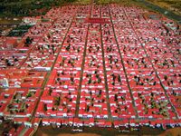
Augusta Treverorum in the 4th century
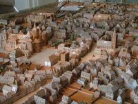
Scale model of Trier around 1800
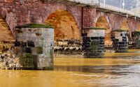
Römerbrücke over the Moselle. (Detail to the north side)


_24.jpg&filetimestamp=20251227111527&)


الجغرافيا
Trier sits in a hollow midway along the Moselle valley, with the most significant portion of the city on the east bank of the river. Wooded and vineyard-covered slopes stretch up to the Hunsrück plateau in the south and the Eifel in the north. The border with the Grand Duchy of Luxembourg is some 15 km (9 mi) away.
البلديات المجاورة
Listed in clockwise order, beginning with the northernmost; all municipalities belong to the Trier-Saarburg district
Schweich, Kenn and Longuich (all part of the Verbandsgemeinde Schweich an der Römischen Weinstraße), Mertesdorf, Kasel, Waldrach, Morscheid, Korlingen and Gusterath (all in the Verbandsgemeinde Ruwer), Hockweiler, Franzenheim (both part of the Verbandsgemeinde Trier-Land), Konz and Wasserliesch (both part of the Verbandsgemeinde Konz), Igel, Trierweiler, Aach, Newel, Kordel, Zemmer (all in the Verbandsgemeinde Trier-Land).
أحياء المدينة

The Trier urban area is divided into 19 city districts. For each district there is an Ortsbeirat (local council) of between 9 and 15 members, as well as an Ortsvorsteher (local representative). The local councils are charged with hearing the important issues that affect the district, although the final decision on any issue rests with the city council. The local councils nevertheless have the freedom to undertake limited measures within the bounds of their districts and their budgets.
The districts of Trier with area and inhabitants (December 31, 2009):
| الرقم الرسمي للقسم | الحي والمجاورات | المساحة كم² |
السكان |
|---|---|---|---|
| 11 | Mitte/Gartenfeld | 2.978 | 11,954 |
| 12 | Nord (Nells Ländchen, Maximin) | 3.769 | 13,405 |
| 13 | Süd (St. Barbara, St. Matthias or St. Mattheis) | 1.722 | 9,123 |
| 21 | Ehrang/Quint | 26.134 | 9,195 |
| 22 | Pfalzel | 2.350 | 3,514 |
| 23 | Biewer | 5.186 | 1,949 |
| 24 | Ruwer/Eitelsbach | 9.167 | 3,091 |
| 31 | West/Pallien | 8.488 | 7,005 |
| 32 | Euren (Herresthal) | 13.189 | 4,207 |
| 33 | Zewen (Oberkirch) | 7.496 | 3,634 |
| 41 | Olewig | 3.100 | 3,135 |
| 42 | Kürenz (Alt-Kürenz, Neu-Kürenz) | 5.825 | 8,708 |
| 43 | Tarforst | 4.184 | 6,605 |
| 44 | Filsch | 1.601 | 761 |
| 45 | Irsch | 4.082 | 2,351 |
| 46 | Kernscheid | 3.768 | 958 |
| 51 | Feyen/Weismark | 5.095 | 5,689 |
| 52 | Heiligkreuz (Alt-Heiligkreuz, Neu-Heiligkreuz, St. Maternus) | 2.036 | 6,672 |
| 53 | Mariahof (St. Michael) | 7.040 | 3,120 |
| الإجمالي | 117.210 | 105,076 |
المناخ
Trier has an oceanic climate (Köppen: Cfb), but with greater extremes than the marine versions of northern Germany. Summers are warm except in unusual heat waves and winters are recurrently cold, but not harsh. Precipitation is high despite not being on the coast.[13] As a result of the European heat wave in 2003, the highest temperature recorded was 39 °C on 8 August of that year. The lowest recorded temperature was −19.3 °C on February 2, 1956.[14]
| بيانات المناخ لـ Trier (Petrisberg), elevation: 265 m, 1971–2000 normals | |||||||||||||
|---|---|---|---|---|---|---|---|---|---|---|---|---|---|
| الشهر | ينا | فب | مار | أبر | ماي | يون | يول | أغس | سبت | أكت | نوف | ديس | السنة |
| متوسط القصوى اليومية °س (°ف) | 3.7 (38.7) |
5.3 (41.5) |
9.8 (49.6) |
13.7 (56.7) |
18.6 (65.5) |
21.3 (70.3) |
23.8 (74.8) |
23.9 (75.0) |
19.5 (67.1) |
13.7 (56.7) |
7.4 (45.3) |
4.7 (40.5) |
13.8 (56.8) |
| المتوسط اليومي °س (°ف) | 1.4 (34.5) |
2.1 (35.8) |
5.6 (42.1) |
8.5 (47.3) |
13.1 (55.6) |
15.9 (60.6) |
18.1 (64.6) |
17.8 (64.0) |
14.0 (57.2) |
9.6 (49.3) |
4.7 (40.5) |
2.5 (36.5) |
9.4 (49.0) |
| متوسط الدنيا اليومية °س (°ف) | −0.9 (30.4) |
−0.8 (30.6) |
2.0 (35.6) |
4.0 (39.2) |
8.2 (46.8) |
11.1 (52.0) |
13.0 (55.4) |
12.8 (55.0) |
9.8 (49.6) |
6.3 (43.3) |
2.3 (36.1) |
0.4 (32.7) |
5.7 (42.2) |
| متوسط تساقط الأمطار mm (inches) | 62.3 (2.45) |
52.0 (2.05) |
60.8 (2.39) |
52.0 (2.05) |
67.0 (2.64) |
68.0 (2.68) |
72.3 (2.85) |
59.6 (2.35) |
62.2 (2.45) |
70.5 (2.78) |
70.7 (2.78) |
76.8 (3.02) |
774.2 (30.49) |
| Average precipitation days (≥ 1.0 mm) | 12.2 | 9.7 | 11.6 | 9.4 | 11.3 | 11.2 | 10.2 | 8.4 | 9.1 | 10.5 | 11.6 | 12.3 | 127.5 |
| Source: DWD | |||||||||||||
| بيانات المناخ لـ Trier (Petrisberg), elevation: 273 m, 1961–1990 normals and extremes | |||||||||||||
|---|---|---|---|---|---|---|---|---|---|---|---|---|---|
| الشهر | ينا | فب | مار | أبر | ماي | يون | يول | أغس | سبت | أكت | نوف | ديس | السنة |
| القصوى القياسية °س (°ف) | 14.3 (57.7) |
18.1 (64.6) |
23.7 (74.7) |
28.5 (83.3) |
30.7 (87.3) |
34.6 (94.3) |
37.1 (98.8) |
35.8 (96.4) |
33.1 (91.6) |
26.3 (79.3) |
19.4 (66.9) |
17.0 (62.6) |
37.1 (98.8) |
| متوسط القصوى اليومية °س (°ف) | 3.1 (37.6) |
5.1 (41.2) |
9.1 (48.4) |
13.4 (56.1) |
18.1 (64.6) |
21.2 (70.2) |
23.3 (73.9) |
22.9 (73.2) |
19.5 (67.1) |
14.1 (57.4) |
7.4 (45.3) |
4.0 (39.2) |
13.4 (56.2) |
| المتوسط اليومي °س (°ف) | 0.9 (33.6) |
1.9 (35.4) |
4.9 (40.8) |
8.4 (47.1) |
12.6 (54.7) |
15.7 (60.3) |
17.6 (63.7) |
17.1 (62.8) |
14.0 (57.2) |
9.8 (49.6) |
4.6 (40.3) |
1.8 (35.2) |
9.1 (48.4) |
| متوسط الدنيا اليومية °س (°ف) | −1.4 (29.5) |
−0.9 (30.4) |
1.4 (34.5) |
4.0 (39.2) |
7.8 (46.0) |
10.9 (51.6) |
12.5 (54.5) |
12.3 (54.1) |
9.7 (49.5) |
6.4 (43.5) |
2.2 (36.0) |
−0.4 (31.3) |
5.4 (41.7) |
| الصغرى القياسية °س (°ف) | −18.3 (−0.9) |
−14.6 (5.7) |
−12.9 (8.8) |
−6.2 (20.8) |
−1.6 (29.1) |
1.7 (35.1) |
4.4 (39.9) |
4.2 (39.6) |
1.2 (34.2) |
−3.4 (25.9) |
−10.2 (13.6) |
−14.4 (6.1) |
−18.3 (−0.9) |
| متوسط تساقط الأمطار mm (inches) | 60.0 (2.36) |
55.0 (2.17) |
64.0 (2.52) |
53.0 (2.09) |
68.0 (2.68) |
73.0 (2.87) |
70.0 (2.76) |
71.0 (2.80) |
59.0 (2.32) |
65.0 (2.56) |
74.0 (2.91) |
72.0 (2.83) |
784 (30.87) |
| Average precipitation days (≥ 1.0 mm) | 12.0 | 10.0 | 12.0 | 10.0 | 12.0 | 11.0 | 10.0 | 10.0 | 9.0 | 9.0 | 12.0 | 12.0 | 129 |
| Mean monthly ساعات سطوع الشمس | 43.6 | 76.9 | 114.3 | 156.9 | 203.4 | 206.3 | 225.5 | 200.5 | 152.4 | 103.3 | 49.4 | 40.1 | 1٬572٫6 |
| Source: NOAA[15] | |||||||||||||
المعالم الرئيسية
| موقع تراث عالمي حسب اليونسكو | |
|---|---|
 Ruins of the Imperial Baths | |
| Includes | Amphitheater, Roman bridge, Barbara Baths, Igel Column, Porta Nigra, Imperial Baths, Aula Palatina, Cathedral and Liebfrauenkirche |
| السمات | Cultural: i, iii, iv, vi |
| مراجع | 367 |
| التدوين | 1986 (10 Session) |

يوجد في قلب المدينة نافورة قديمة اسمها Trebeta-Brunnen "نافورة تريبيتا" وعبارة لاتينيّة منقوشة على المنزل الأحمر في قلب المدينة، وهي:
ANTE ROMAM TREVIRIS STETIT ANNIS MILLE TRECENTIS.
PERSTET ET ÆTERNA PACE FRVATVR. AMEN
أبرز السكان
See Heinz Monz: Trierer Biographisches Lexikon. Landesarchivverwaltung Rheinland-Pfalz, Koblenz 2000. 539 p. ISBN 3-931014-49-5.


- Eucharius (died ~250), first bishop of Trier
- Constantius I. Chlorus (ca. 250-306), Roman emperor
- Maximian (ca. 250–310), Roman emperor
- Valerius (died 320), second bishop of Trier
- St Athanasius (In exile ca. 335)
- Helena (ca. 250–330), saint, mother of Constantine the Great (residence in Trier by tradition)[16][17]
- Constantine the Great (ca. 272-337), Roman emperor
- Paulinus (died 358), bishop of Trier
- Valentinian I (321–375), Roman emperor
- Ausonius (ca. 310–395), Roman consul and poet
- Ambrose (ca. 340–397), saint
- Apronia of Toul, (6th century), nun and saint
- Kaspar Olevianus (1536–1587), theologian
- Heinrich (1777–1838) and Henriette Marx (1788–1863), parents of Karl Marx
- Johann Anton Ramboux (1790–1866), painter
- Jenny Marx née von Westphalen (1814–1881), revolutionary, drama critic, wife of Karl Marx, mother of Jenny Longuet, Laura Marx and Eleanor Marx
- Karl Marx (1818–1883), German social philosopher and revolutionary
- August Beer (1825–1863), scientist
- Frederick A. Schroeder (1833–1899), American politician, mayor of Brooklyn
- Hans am Ende (1864–1918), German painter
- Ludwig Kaas (1881–1952), Catholic priest and politician of the Zentrum
- Oswald von Nell-Breuning (1890–1991), German theologian
- Charles de Gaulle (1890–1970), General and French statesman, as commander of a battalion of Chasseurs during the French occupation of Rhineland
- Reinhard Heß (1904–1998), painter and glass painter
- Wolf Graf von Baudissin (1907–1993), German general, military planner and peace researcher
- Peter Thullen (1907–1996), German-Ecuadorian mathematician
- Klaus Barbie (1913–1991), SS and Gestapo functionary during the Nazi era.
- Gitta Lind (1925–1974), singer (e.g. "White Elder")
- Reinhold Bartel (1926–1996), operatic tenor
- Ernst Huberty (born 1927), sports reporter ("Mister Sportschau")
- Günther Steines (1928–1982), athlete
- Franz Grundheber (born 1937), baritone
- Otmar Seul (born 1943), lawyer, professor
- Helga Zepp-LaRouche (born 1948), journalist and politician
- Xavier Bout de Marnhac (born 1951), French general, former commander of KFOR
- Robert Zimmer (born 1953), German philosopher and essayist
- Ernst Ulrich Deuker (born 1954), musician of Ideal
- François Weigel (born 1964), French pianist, composer and conductor
- Eric Jelen (born 1965), tennis player
- Martin Bambauer (born 1970), church musician
- Frank Findeiß (born 1971), poet
- The Shanes (German polka band)
بلدات توأم
ترير متوأمة مع:
|
بلدات سميت على اسمها
 New Trier Township, Cook County, Illinois, originally settled by people from Trier.
- New Trier, Minnesota, settled by people from Trier circa 1856.
الهامش
- ^ "Treverer und Römer - Die Gründung der Stadt" (in الألمانية). 2025-08-16.
- ^ Wolfram Leibe (SPD) bleibt Oberbürgermeister in Trier Archived 2022-10-08 at the Wayback Machine, SWR Aktuell, 25 September 2022.
- ^ "Trier" (US) and قالب:Cite Oxford Dictionaries
- ^ قالب:Cite Merriam-Webster
- ^ "Trèves" (US) and قالب:Cite Oxford Dictionaries
- ^ "Trèves". The American Heritage Dictionary of the English Language (5th ed.). HarperCollins. Retrieved April 2, 2019.
- ^ Rathaus der Stadt Trier. "Stadt Trier – City of Trier – La Ville de Trèves | Website of the Municipality of Trier". Archived from the original on 2002-08-08. Retrieved 2015-08-26.
- ^ An honor that is contested by Cologne, Kempten, and Worms.
- ^ أ ب "Roman Monuments, Cathedral of St Peter and Church of Our Lady in Trier". UNESCO World Heritage Centre. United Nations Educational, Scientific, and Cultural Organization. Retrieved 22 May 2022.
- ^ "Bevölkerung der Gemeinden am 31.12.2010" (PDF). Statistisches Landesamt Rheinland-Pfalz (in الألمانية). 2011. Archived from the original (PDF) on 2012-01-31.
- ^ List of Stolperstein in Trier (in German).
- ^ Trier: Five die as car ploughs through Germany pedestrian zone. BBC News. Retrieved 2021-01-04.
- ^ "Trier, Germany Köppen Climate Classification (Weatherbase)". Weatherbase. Retrieved 2019-02-02.
- ^ "Wetterrekorde Deutschland". Wetterdienst.de (in الألمانية). Retrieved 2019-02-02.
- ^ "Trier (10609) – WMO Weather Station". NOAA. Retrieved February 2, 2019.
- ^ "Catholic Encyclopedia – St. Helena – Ökumenisches Heiligenlexikon". heiligenlexikon.de. Retrieved 2015-08-26.
- ^ "Trierer Persönlichkeiten aus über 2000 Jahren: Kaiserin Helena" [Trier personalities from over 2000 years: Empress Helena]. Trier.de (in German). City of Trier. Retrieved February 23, 2020.
{{cite web}}: CS1 maint: unrecognized language (link) - ^ "Međunarodna suradnja Grada Pule". Grad Pula (in Croatian and Italian). Archived from the original on 2012-05-05. Retrieved 2013-07-28.
{{cite web}}: CS1 maint: unrecognized language (link) - ^ "Fort Worth". Sister Cities International. Archived from the original on 2014-04-13. Retrieved 2014-04-11.
وصلات خارجية
قالب:Germany districts rhineland-palatinate
- Pages using gadget WikiMiniAtlas
- CS1 الألمانية-language sources (de)
- Short description is different from Wikidata
- Articles with hatnote templates targeting a nonexistent page
- Missing redirects
- Articles containing لوكسمبورگية-language text
- Pages using multiple image with auto scaled images
- Coordinates on Wikidata
- Germany articles requiring maintenance
- المدن in Rhineland-Palatinate
- Pages using Lang-xx templates
- Pages with plain IPA
- Articles containing فرنسية-language text
- Articles containing لاتينية-language text
- مواقع التراث العالمي في ألمانيا
- ترير
- تأسيسات 16 ق.م.
- Cities in Rhineland-Palatinate
- معالم ألمانيا
- بلدات ومدن رومانية في ألمانيا
- مواقع تراث عالمي في ألمانيا
- جاليات يهودية تاريخية
- مدن ألمانيا