خانق نهر كلومبيا Columbia River Gorge
| Columbia River Gorge | |
|---|---|
 Looking east up the Columbia River Gorge from near Multnomah Falls. | |
 | |
| الموقع | Pacific Northwest, United States |
| تأسست | 1986 |
| الموقع الإلكتروني | www |
خانق نهر كلومبيا Columbia River Gorge هو أخدود يمر فيه نهر كلومبيا في الشمال الغربي الهادي في الولايات المتحدة. Up to 4،000 أقدام (1،200 m) deep, the canyon stretches for over ثمانون ميل (130 km) as the river winds westward through the Cascade Range, forming the boundary between the state of Washington to the north and Oregon to the south.[1] Extending roughly from the confluence of the Columbia with the Deschutes River (and the towns of Roosevelt, Washington, and Arlington, Oregon) in the east down to the eastern reaches of the Portland metropolitan area, the water gap furnishes the only navigable route through the Cascades and the only water connection between the Columbia Plateau and the Pacific Ocean. It is thus that the routes of Interstate 84, U.S. Route 30, Washington State Route 14, and railroad tracks on both sides run through the gorge.
A popular recreational destination, the gorge holds federally protected status as the Columbia River Gorge National Scenic Area and is managed by the Columbia River Gorge Commission and the U.S. Forest Service.
الوصف
The Columbia River, Klamath River in northern California, Pit River in northern California, and Fraser River in southern British Columbia are the only four rivers connecting the watersheds on the east side of the Cascade Range to the Pacific Ocean. Each river has carved out a gorge through the Cascades. The Columbia River Gorge marks the state line between Oregon and Washington, and its wide range of elevation and precipitation makes it an extremely diverse and dynamic place. Ranging from 4،000 أقدام (1،200 m) to sea level, and transitioning from 100 بوصات (2،500 mm) of precipitation to only 10 بوصات (250 mm) in 80 ميل (130 km), the gorge provides the setting for a diverse collection of ecosystems, from the temperate rain forest on the western end—with an average annual precipitation of 75 إلى 100 بوصات (1،900 إلى 2،500 mm)—to the eastern grasslands with average annual precipitation between 10 و 15 بوصات (250 و 380 mm), to a transitional dry woodland between Hood River and The Dalles.[citation needed] Isolated micro-habitats have allowed for many species of endemic plants and animals to prosper, including at least 13 endemic wildflowers.

The gorge transitions between temperate rainforest to dry grasslands in only 80 ميل (130 km), hosting a dramatic change in scenery while driving along Interstate 84. In the western, temperate rainforest areas, forests are marked by bigleaf maples, Douglas fir, and western hemlock, all covered in epiphytes. In the transition zone (between Hood River and The Dalles), vegetation turns to Oregon white oak, ponderosa pine, and cottonwood. At the eastern end, the forests make way for expansive grasslands, with occasional pockets of lodgepole and ponderosa pine.
Atmospheric pressure differentials east and west of the Cascades create a wind tunnel effect in the deep cut of the gorge, generating 35-ميل-في-الساعة (56 km/h) winds that make it a popular windsurfing and kiteboarding location. It also creates the right conditions for snow and ice storms during the winter months which also draw very cold east winds toward the mouth of the gorge on the west end.
The gorge is a popular destination for hiking, biking, sightseeing, fishing, and water sports. The area is known for its high concentration of waterfalls, with over 90 on the Oregon side of the gorge alone.[2] Many are along the Historic Columbia River Highway, including the notable 620-قدم-high (190 m) Multnomah Falls.
Trails and day use sites are maintained by the Forest Service and many Oregon and Washington state parks.
الجيولوجيا
The Columbia River Gorge began forming as far back as the Miocene (roughly 17 to 12 million years ago), and continued to take shape through the Pleistocene (2 million to 700,000 years ago). During this period the Cascade Range was forming, which slowly moved the Columbia River's delta about 100 ميل (160 km) north to its current location.[3]
Although the river slowly eroded the land over this period of time, the most drastic changes took place at the end of the last ice age when the Missoula Floods cut the steep, dramatic walls that exist today, flooding the river as high up as Crown Point.[4] This quick erosion left many layers of volcanic rock exposed.[3]

البيئة
The Columbia River Gorge is home to a number of plant species that are endemic or found mostly in the gorge and surrounding areas, including Heterotheca villosa, Lomatium columbianum, Lomatium klickitatense, Lomatium suksdorfii, Penstemon barrettiae, and Primula poetica.[5]
التاريخ

The gorge has supported human habitation for over 13,000 years. Evidence of the Folsom and Marmes people, who crossed the Bering land bridge from Asia, were found in archaeological digs. Excavations near Celilo Falls, a few miles east of The Dalles, show humans have occupied this salmon-fishing site for more than 10,000 years.[citation needed]
The gorge has provided a transportation corridor for thousands of years. Native Americans would travel through the gorge to trade at Celilo Falls, both along the river and over Lolo Pass on the north side of Mount Hood. In 1805, the route was used by the Lewis and Clark Expedition to reach the Pacific.[6] Early European and American settlers subsequently established steamboat lines and railroads through the gorge. Today, the BNSF Railway runs freights along the Washington side of the river, while its rival, the Union Pacific Railroad, runs freights along the Oregon shore. Until 1997, Amtrak's Pioneer also used the Union Pacific tracks. The Portland segment of the Empire Builder uses the BNSF tracks that pass through the gorge.
The Columbia River Highway, built in the early 20th century, was the first major paved highway in the Pacific Northwest. Shipping was greatly simplified after Bonneville Dam and The Dalles Dam submerged the gorge's major rapids such as Celilo Falls, a major salmon fishing site for local Native Americans until the site's submergence in 1957.

In November 1986, Congress made the gorge the second U.S. National Scenic Area and established the Columbia River Gorge Commission as part of an interstate compact.[7] The experimental designation came in lieu of being recognized as a national park, which would require the existing industries in towns along the river to relocate. The designation was initially opposed by residents fearing government encroachment, due to restrictions in the plan for items such as building paint colors, and was also opposed by conservationists who feared additional development in the region.[8] In 2004, the gorge became the namesake of the Columbia Gorge American Viticultural Area, a 4،432-acre (1،794 ha) area located on both sides of the river.
In fall 2017, the Eagle Creek Fire burned in the gorge for three months, consuming almost 50،000 acre (78 sq mi; 200 km2). It reached 100% containment on November 30, 2017, but was not yet completely out.[9]
معرض صور
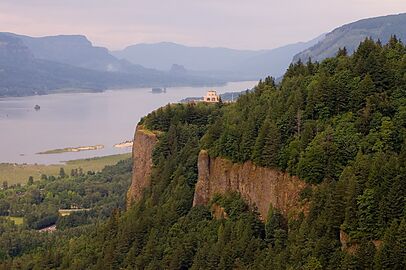
Crown Point in the Columbia River Gorge, looking upstream from Chanticleer Point

Columbia River Gorge, photographed from the southern edge of the Gifford Pinchot National Forest
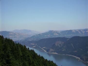
The view east towards The Dalles from Dog Mountain
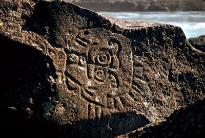
Native American petroglyphs in the Columbia River Gorge near The Dalles Dam

Kitesurfing on the Columbia River
View of Columbia River Gorge from Cape Horn Trail, looking east toward Beacon Rock

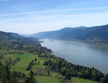
Columbia River Gorge, photographed from Crown Point.
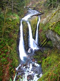
Triple Falls
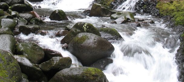
Oneonta Creek

Horsethief Butte, near The Dalles
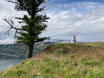
A couple overlooks the Columbia River Gorge from a viewpoint near Mosier, Oregon

A view of the Oregon side of the Columbia River Gorge from Hamilton Mountain

Columbia River Gorge with Mount Adams and Mount Saint Helens barely visible, seen from the Devils Rest Trail


انظر أيضاً
- Barlow Road, the first wagon-compatible pioneer road to provide a safer alternative to traveling through the gorge
- Cascades Rapids
- Proposed Columbia Gorge casino, a proposed off-reservation casino in Cascade Locks
- Wahclella Falls
- Nancy Neighbor Russell, conservationist and co-founder of Friends of the Columbia Gorge
المراجع
- ^ Staats, David (نوفمبر 21, 1983). "The Gorge". Spokane Chronicle. (Washington). Associated Press. p. A15.
- ^ "Columbia River Gorge of Oregon". Northwest Waterfall Survey. Retrieved February 6, 2011.
- ^ أ ب "Columbia River Gorge". Northwest Power and Conservation Council. 2021. Archived from the original on يوليو 8, 2007. Retrieved يونيو 2, 2008.
- ^ Dietrich, William (سبتمبر 30, 2007). "Trailing An Apocalypse". The Seattle Times, Pacific Northwest Magazine (in الإنجليزية الأمريكية). Retrieved أكتوبر 23, 2021.
- ^ "iNaturalist". Retrieved January 6, 2023.
- ^ O'Connor, Jim E. (Fall 2004). "The Evolving Landscape of the Columbia River Gorge: Lewis and Clark and Cataclysms on the Columbia". Oregon Historical Quarterly. 105 (3): 390–421. doi:10.1353/ohq.2004.0043. S2CID 131976728. Archived from the original on مارس 28, 2009.
- ^ Columbia River Gorge National Scenic Area Act Archived 2015-04-08 at the Wayback Machine from GorgeFriends.org
- ^ Geranios, Nicholas K. (يونيو 3, 1990). "Columbia Gorge controversy smolders". The Seattle Times. Associated Press. p. B3.
- ^ Ryan, Jim (نوفمبر 30, 2017). "Columbia Gorge fire declared 100 percent contained; hot spots still possible". The Oregonian. Retrieved ديسمبر 5, 2017.
وصلات خارجية
- U.S. Forest Service - Columbia River Gorge National Scenic Area
- Columbia River Gorge Commission
- The Gorge Magazine
- قالب:Oregon Encyclopedia
- Portland State University Columbia River Gorge National Scenic Area Collection—contains research material used to write the book Planning a New West: The Columbia River Gorge National Scenic Area
- The River They Saw Documentary produced by Oregon Public Broadcasting
| المقاطعات والولايات التي يعبرها |  | |
|---|---|---|
| قوائم | ||
| الجيولوجيا والجغرافيا | ||
| التاريخ | Celilo Falls • Kettle Falls • Dalles des Morts • Robert Gray exploration • بعثة لويس وكلارك • David Thompson • Astor Expedition • Fort Vancouver • Steamboats of the Columbia River • Big Bend Gold Rush • Steamboats of the Arrow Lakes • Steamboats of the upper Columbia and Kootenay Rivers • Columbia River Treaty • Historic Columbia River Highway • Columbia Basin Project • Bonneville Power Administration • Hanford Site • Sohappy v. Smith • Boldt Decision • Vanport flood of 1948 | |
| البيئة والثقافة | ||
- CS1 الإنجليزية الأمريكية-language sources (en-us)
- Pages using gadget WikiMiniAtlas
- Short description is different from Wikidata
- Articles with hatnote templates targeting a nonexistent page
- Missing redirects
- Use American English from January 2020
- All Wikipedia articles written in American English
- Use mdy dates from January 2020
- Articles with unsourced statements from February 2008
- Portal-inline template with redlinked portals
- Pages with empty portal template
- Coordinates on Wikidata
- Columbia River Gorge
- Archaeological sites in Oregon
- Archaeological sites in Washington (state)
- Valleys of Oregon
- Valleys of Washington (state)
- Protected areas of Clark County, Washington
- Columbia River
- Protected areas of Hood River County, Oregon
- Protected areas of Klickitat County, Washington
- Protected areas of Multnomah County, Oregon
- National scenic areas
- Protected areas of Sherman County, Oregon
- Protected areas of Skamania County, Washington
- Protected areas of Wasco County, Oregon
- Mount Hood National Forest
- Landforms of Clark County, Washington
- Landforms of Hood River County, Oregon
- Landforms of Klickitat County, Washington
- Landforms of Multnomah County, Oregon
- Landforms of Sherman County, Oregon
- Landforms of Skamania County, Washington
- Landforms of Wasco County, Oregon
- United States Forest Service protected areas
- Water gaps of Washington (state)
- Water gaps of the United States