راينلاند
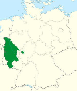
راينلاند أرض تاريخية تُسمَّى اليوم ألمانيا، وتقع على طول نهر الراين، وتمتد غربًا حتى حدود بلجيكا وفرنسا ولوكسمبرج وهولندا.
بعض المدن الكبرى في راينلاند تتضمن آخن وبون وكولونيا ودويسبورگ ودوسلدورف وكوبلنز وكريفلد ولڤركوزن، ترير.
استوطن الناس في الراينلاند خلال العصور القديمة، وقد حكمها عبر الزمن أقوام مختلفون، مثل الكلت والرومان والهون والفرانكيين. وقد بدأت عدة مدن تكتسب أهمية في المنطقة قرابة عام 800 م، مثل مدينة كولون وماينتس وترير، وأصبحت خلال وقت قصير المراكز الدينية والسياسية للإمبراطورية الرومانية المقدسة، وكانت الراينلاند تشكل جزءًا من فرنسا في أثناء حروب نابليون في أواخر القرن الثامن عشر، ثم أصبحت جزءًا من مقاطعة بروسيا الألمانية عام 1815م.
المصطلح
Historically, the term "Rhinelands"[1] refers to a loosely defined region encompassing the land on the banks of the Rhine, which were settled by Ripuarian and Salian Franks and became part of Frankish Austrasia. In the High Middle Ages, numerous Imperial States along the river emerged from the former stem duchy of Lotharingia, without developing any common political or cultural identity.
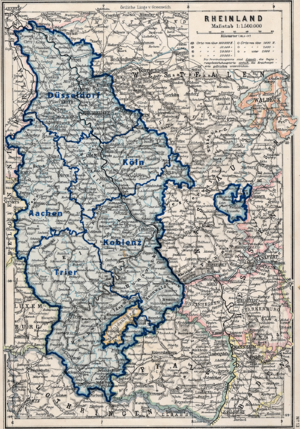
A "Rhineland" conceptualization can be traced to the period of the Holy Roman Empire from the sixteenth until the eighteenth centuries when the Empire's Imperial Estates (territories) were grouped into regional districts in charge of defense and judicial execution, known as Imperial Circles. Three of the ten circles through which the Rhine flowed referred to the river in their names: the Upper Rhenish Circle, the Electoral Rhenish Circle, and the Lower Rhenish-Westphalian Circle (very roughly equivalent to the present-day German federal state of North Rhine Westphalia). In the twilight period of the Empire, after the War of the First Coalition, a short-lived Cisrhenian Republic was established (1797–1802). The term covered the whole French annexed territory west of the Rhine (German: Linkes Rheinufer), but also included a small portion of the bridgeheads on the eastern banks. After the defeat of the French empire, the regions of Jülich-Cleves-Berg and Lower Rhine were annexed[citation needed] to the Kingdom of Prussia. In 1822 the Prussian administration reorganized the territory as the Rhine Province (Rheinprovinz, also known as Rhenish Prussia), a tradition that continued in the naming of the current German states of Rhineland-Palatinate and North Rhine-Westphalia.
الجغرافيا

To the west the area stretches to the borders with Luxembourg, Belgium, and the Netherlands; on the eastern side, it encompasses the towns and cities along the river and the Bergisches Land area up to the Westphalian (Siegerland) and Hessian regions. Stretching down to the North Palatine Uplands in the south, this area, except for the Saarland, more or less corresponds with the modern use of the term.
The southern and eastern parts are mainly hill country (Westerwald, Hunsrück, Siebengebirge, Taunus and Eifel), cut by river valleys, principally the Middle Rhine up to Bingen (or very rarely between the confluence with the Neckar and Cologne[2]) and its Ahr, Moselle and Nahe tributaries. The border of the North German plain is marked by the lower Ruhr. In the south, the river cuts the Rhenish Massif.
The area encompasses the western part of the Ruhr industrial region and the Cologne Lowland. Some of the larger cities in the Rhineland are Aachen, Bonn, Cologne, Duisburg, Düsseldorf, Essen, Koblenz, Krefeld, Leverkusen, Mainz, Mönchengladbach, Mülheim an der Ruhr, Oberhausen, Remscheid, Solingen, Trier and Wuppertal.
Toponyms as well as local family names often trace back to the Frankish heritage.[citation needed]The lands on the western shore of the Rhine are strongly characterized by Roman influence, including viticulture. In the core territories, large parts of the population are members of the Catholic Church.
التاريخ
قبل الرومان
At the earliest historical period, the territories between the Ardennes and the Rhine were occupied by the Treveri, the Eburones, and other Celtic tribes, who, however, were all more or less modified and influenced by their Germanic neighbors. On the East bank of the Rhine, between the Main and the Lahn, were the settlements of the Mattiaci, a branch of the Germanic Chatti, while farther to the north were the Usipetes and Tencteri.[3]
التفوذ الپروسي
A Prussian influence began on a small scale in 1609 by the occupation of the Duchy of Cleves. A century later, Upper Guelders and Moers also became Prussian. The Congress of Vienna expelled the French and assigned the whole of the lower Rhenish districts to Prussia, who left them in undisturbed possession of the liberal institutions to which they had become accustomed under the French.[3] The Rhine Province remained part of Prussia after Germany was unified in 1871.[4]
بعد الحرب العالمية الأولى
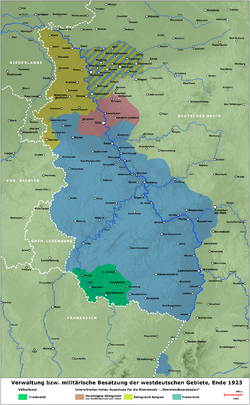
ساعد توفّر المصادر المعدنية الغنيّة في المنطقة، وكذلك موقع نهر الراين، على تطوير المراكز الصناعية بما فيها منطقة مناجم الفحم الحجري في الرور. وبعد الحرب العالمية الأولى (1914 – 1918م)، وقَّعت ألمانيا على اتفاقية تقضي بعدم تحصين المنطقة وعدم وضع جيوش فيها. ولكن الجيوش الألمانية احتلَّت الراينلاند عام 1936م، واستخدمتها لأغراض عسكرية خلال الحرب العالمية الثانية (1939-1945). واليوم، فإن هذه المنطقة تُشكِّل جزءاً من المنطقة الصناعية في ألمانيا. ويقوم السّياح بزيارة المنطقة للاستمتاع بِمُدنها الجميلة، وقلاعها التاريخية، والسهول الخضراء الواسعة.
بعد 1946
In 1946, the Rhineland was divided into the newly founded states of Hesse, North Rhine-Westphalia, and Rhineland-Palatinate.[5][6] North Rhine-Westphalia is one of the prime German industrial areas, containing significant mineral deposits (coal, lead, lignite, magnesium, oil, and uranium) and water transport. In the Rhineland-Palatinate agriculture is more important, including the vineyards في مناطق Ahr, Mittelrhein وMosel .
انظر أيضاً
المصادر
- Walter Marsden: The Rhineland. Hastingshouse/Daytrips Publ., ISBN 0803820704 (online version (Google Books)
- Ken Ford, Tony Brian: The Rhineland 1945: The Last Killing Ground in the West. Osprey Publishing 2000, ISBN 1855329999
- Rhineland at Microsoft Encarta
- ^ Dickinson, Robert E. (1964). Germany: A regional and economic geography (2nd ed.). London: Methuen. pp. 357f. ASIN B000IOFSEQ.
- ^ Marsden, Walter (1973). The Rhineland. New York: Hastings House. ISBN 0-8038-6324-1.
- ^ أ ب
 Chisholm, Hugh, ed. (1911). . دائرة المعارف البريطانية. Vol. 23 (eleventh ed.). Cambridge University Press. pp. 242–243.
 {{cite encyclopedia}}: Cite has empty unknown parameter:|coauthors=(help) - ^ Muirhead, James Fullarton (1886). . Encyclopædia Britannica. Vol. XX (9th ed.).
- ^ "States of Occupied Germany [Länder] (1947)". German History in Documents and Images (in الإنجليزية الأمريكية). Retrieved 2025-09-29.
- ^ "Hessen is..." (PDF). Archived from the original (PDF) on 2025-02-17.
- Short description is different from Wikidata
- Articles containing ألمانية-language text
- Articles with unsourced statements from January 2025
- Articles with hatnote templates targeting a nonexistent page
- مناطق ألمانيا
- مقالات المعرفة المحتوية على معلومات من دائرة المعارف البريطانية طبعة 1911
- Wikipedia articles incorporating a citation from EB9
- CS1 الإنجليزية الأمريكية-language sources (en-us)
