كاليثيا
Kallithea
Καλλιθέα (Greek) | |
|---|---|
Aerial view of the city with the Acropolis of Athens in the background Church of Metamorphosis Sotiros Canal of Stavros Niarchos Park Marina Delta | |
 Kallithea الموقع في المنطقة  | |
| الإحداثيات: 37°57′N 23°42′E / 37.950°N 23.700°E | |
| البلد | |
| المنطقة الادارية | Attica |
| الوحدة المحلية | South Athens |
| الحكومة | |
| • العمدة | Konstantinos Askounis[1] (منذ 2023) |
| المساحة | |
| • البلدية | 4٫749 كم² (1٫834 ميل²) |
| المنسوب | 25 m (82 ft) |
| التعداد (2021) | |
| • البلدية | 97٬616 |
| • كثافة البلدية | 21٬000/km2 (53٬000/sq mi) |
| منطقة التوقيت | UTC+2 (EET) |
| • الصيف (التوقيت الصيفي) | UTC+3 (EEST) |
| Postal code | 176 xx |
| مفتاح الهاتف | 210 |
| Vehicle registration | Z |
| الموقع الإلكتروني | www.kallithea.gr |


.jpeg&filetimestamp=20250820201657&)

كاليثي (Καλλιθέα) هي مدينة في كسانثي في مقاطعة فوريا إلادا في اليونان. ويبلغ عدد سكانها حوالي 1148 نسمة.
الموقع


The center of Kallithea (Davaki Square) lies at a distance of 3 km (2 ميل) to the south of the Athens city center (Syntagma Square) and 3 km (2 mi) to the north-east of the Piraeus (photo 1). Kallithea extends from the Filopappou and Sikelia hills in the north to Phaleron Bay in the south; its two other sides consist of Syngrou Avenue to the east (border to the towns of Nea Smyrni and Palaio Faliro), and the Ilisos River to the west (border to the towns of Tavros and Moschato) (photo 2).
The site on which the city was developed covers the biggest part of the area to the south of Athens city center, protected in ancient times (5th century BC) by the Long Walls to the west and the Phalerum Wall to the east (photo 3). Somewhere within this area the ancient town of Xypete lay. The town and its citizens are mentioned, among other places, in Plato's Dialogs.
التاريخ
تطورت المدبنة الحديثة فوق منطقة قديمة كانت تقع بين الأسوار الدفاعية لأثينا، وكانت موقعاً لقرية كزيبيته والتي تم ذكرها في العديد من المصادر القديمة مثل حوارات أفلاطون.
بدأ الإعمار الحديث للمدينة عام 1884 ، وسرعان ما ازدادت أهمية كاليثيا بسبب قربها من أثينا حيث استضافت العديد من مسابقات دورة الألعاب الأولمبية الحديثة الأولى عام 1896. نمت المدينة نمواً سريعاً وخاصةً في عشرينيات القرن الماضي لاستقبالها الكثير من لاجئي آسيا الصغرى إثر الحروب التركية-اليونانية، وأيضاً لاجئي سواحل البحر الأسود على إثر الثورة البلشفية. أيضاً كانت المدينة مرة أخرى المركز المفضل للمهاجرين اليونانيي الأصل من الإتحاد السوفياتي السابق بعد تفككه في تسعينيات القرن الماضي.
في عام 2004 ساهمت البلدية مع بلدية أثينا باستضافة الألعاب الأولمبية الصيفية ضمن مجمع ساحل كاليثيا الأولمبي.
الجغرافيا
تقع مدينة كاليثيا في جنوب اليونان بين مدينتي أثينا وبيرايوس حيث تبعد 3 كيلومترات إلى الجنوب من مركز أثينا، و3 كيلومترات إلى الشمال الشرقي من بيرايوس، وتمتد جغرافياً من تلال فيلوبابو (Filopappou) و سيكيليا (Sikelia) في الشمال إلى خليج فالرون (Phaleron) في الجنوب.
الديموغرافيا
يبلغ عدد سكان كاليثيا حوالي 110 ألف نسمة وبالتالي تعد ثامن أكبر بلدية في اليونان، ورابع أكبر بلدية ضمن أثينا الكبرى بعد أثينا، بيرايوس، وبيريستيري.
المعالم الرئيسية

- كنيسة أيا إليوسا: وتعود إلى العصر البيزنطي المتأخر.
- المعرض البلدي: ويوجد في بناء لاسكاريدو وهو أقدم أبنية كاليثيا الجديدة.
- مجمع ساحل كاليثيا الأولمبي: يقع على ساحل المدينة ويوجد ضمنه العديد من الملاعب الرياضية
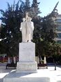
- صرح يونانيي جبال البونتس: ويقع في مركز المدينة.
متفرقات
- يوجد في كاليثيا جامعتين: جامعة هاروكوپيون (Harokopion) ، وجامعة پانتيون (Panteion)
- يعد نادي كاليثيا أف سي أهم نادي كرة قدم في المدينة ومقره إستاد غريغوريس لامبراكيس.
- تعد كاليثيا مركز تاريخي لموسيقا الريبيتيكو و اللايكو الشعبية.
معرض
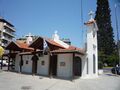
The church Agia Eleousa (Thisseos Avenue)
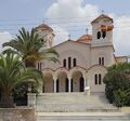
The church Metamorphosi Sotiros

Kallithea Metro station
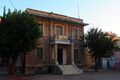
The building of the 20th Primary School of Kallithea
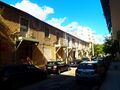
Old refugees' houses in Kallithea

Snow in Davaki Square
One of the Kallithea War Memorial

View of the city from Stavros Niarchos Foundation Center


.jpg&filetimestamp=20250820201700&)


وصلات خارجية
- Municipality of Kallithea homepage
- Panteion University homepage
- Harokopion University homepage
- Kallithea FC homepage
- Esperos sports club homepage
أماكن قريبة من كاليثيا | |
|---|---|
التقسيمات الادارية في إقليم أتيكا | ||
|---|---|---|
| ||
| وسط أثينا |  | |
| شمال أثينا | ||
| غرب أثينا | ||
| جنوب أثينا | ||
| پيريه | ||
| شرق أتيكا | ||
| غرب أتيكا | ||
| الجزر | ||
| ||
قالب:1896 Summer Olympic venues قالب:Olympic venues shooting
- ^ Municipality of Kallithea, Municipal elections – October 2023, Ministry of Interior
- Pages using gadget WikiMiniAtlas
- Short description is different from Wikidata
- Articles containing Greek-language text
- Pages using multiple image with auto scaled images
- Coordinates on Wikidata
- Pages using infobox Greece place with unknown parameters
- 1896 Summer Olympic venues
- 2004 Summer Olympic venues
- Olympic shooting venues
- بلديات أتيكا
- أماكن مأهولة في جنوب أثينا (وحدة محلية)
- كاليثيا
- مدن اليونان