لانگر Langres
Langres | |
|---|---|
Subprefecture and commune | |
 View of Langres from the southeast | |
 Flag .svg&filetimestamp=20231024080814&) Coat of arms | |
Location of Langres خطأ: الوظيفة "main" غير موجودة. | |
 Langres  Langres | |
| الإحداثيات: 47°51′48″N 5°20′02″E / 47.8633°N 5.3339°E | |
| البلد | فرنسا |
| المنطقة | گراند إست |
| الإقليم | المارن الأعلى |
| الدائرة | Langres |
| الكانتون | Langres |
| بينالتجمعات | Grand Langres |
| الحكومة | |
| • العمدة (2020–2026) | Anne Cardinal[1] |
| المساحة 1 | 22٫33 كم² (8٫62 ميل²) |
| التعداد (يناير 2019) | 7٬668 |
| • الكثافة | 340/km2 (890/sq mi) |
| منطقة التوقيت | UTC+01:00 (CET) |
| • الصيف (التوقيت الصيفي) | UTC+02:00 (CEST) |
| INSEE/الرمز البريدي | 52269 /52200 |
| المنسوب | 327–475 m (1،073–1،558 ft) (avg. 475 m أو 1،558 ft) |
| 1 French Land Register data, which excludes lakes, ponds, glaciers > 1 km2 (0.386 sq mi or 247 acres) and river estuaries. | |
Langres (فرنسية pronunciation: [lɑ̃ɡʁ] استمع ) is a commune in northeastern France. It is a subprefecture of the department of Haute-Marne, in the region of Grand Est.
التاريخ
As the capital of the Romanized Gallic tribe known as the Lingones, it was called Andematunnum, then Lingones, and now Langres.
A hilltop town, Langres was built on a limestone promontory of the same name. This stronghold was originally occupied by the Lingones. At a later date the Romans fortified the town, which they called Andemantunum, located at a strategic crossroads of twelve Roman roads.[citation needed] The first-century Triumphal Gate and the many artefacts exhibited in the museums are remnants of the town's Gallo-Roman history. After the period of invasions, the town prospered in the Middle Ages, due in part to the growing political influence of its bishops. The diocese covered Champagne, the Duchy of Burgundy, and Franche-Comté, and the bishops obtained the right to coin money in the ninth century and to name the military governor of the city in 927. The Bishop of Langres was a duke and peer of France. The troubled 14th and 15th centuries caused the town to strengthen its defenses, which still give the old city its fortified character, and Langres entered a period of royal tutelage. The Renaissance, which returned prosperity to the town, saw the construction of numerous fine civil, religious and military buildings that still stand today. In the 19th century, a "Vauban" citadel was added.
Main sights
Langres has a historic town center surrounded by defensive walls with a dozen towers and seven gates.
The cathedral of Saint-Mammès is a late 12th-century structure dedicated to Mammes of Caesarea, a 3rd-century martyr.
Culture
Langres is home to producers of an AOC-protected cheese of the same name. It is a soft, pungent cow's milk cheese that is known for its rind, which is washed.
The town was long known for its cutlery industry. Didier Diderot, father of encyclopedist Denis, was a cutler.[2]
A museum called the Denis Diderot House of Enlightenment opened in 2013. This museum, set up in a private mansion from the 16th and 18th centuries, is dedicated to the philosopher Denis Diderot.[3]
Population
| السنة | تعداد | ±% p.a. |
|---|---|---|
| 1968 | 11٬001 | — |
| 1975 | 11٬437 | +0.56% |
| 1982 | 10٬468 | −1.26% |
| 1990 | 9٬987 | −0.59% |
| 1999 | 9٬586 | −0.45% |
| 2007 | 8٬414 | −1.62% |
| 2012 | 7٬905 | −1.24% |
| 2017 | 7٬731 | −0.44% |
| Source: INSEE[4] | ||
Notable people
Langres was the birthplace of:
- Nicolas Ribonnier (ca.1525–1605), Renaissance architect
- Jeanne Mance (1606–1673), the co-founder of Montreal
- Claude Gillot (1673–1722), painter
- Denis Diderot (1713–1784), the philosopher of the Age of Enlightenment, and the editor-in-chief of the Encyclopédie.
- Étienne Jean Bouchu (1714–1773), metallurgist and Encyclopédiste
- Nicolas Fallet (1746–1801), playwright and journalist
- Joseph-Philibert Girault de Prangey (1804–1892), photographer and draughtsman
- Jules Violle (1841–1923), physicist and inventor
- Guy Fréquelin (born 1945), rally driver
- Jean Tabourot, who went by the pen name Thoinot Arbeau and wrote Orchésographie, a book on dance and music.
Climate
Located in the north-east quarter of France, Langres is under the influence of both an oceanic climate and a humid continental climate with no dry season. Winters are cold and snowy (33.4 days of snow per year on average) but interspersed with periods of light thaw and summers are mild and even pleasant with average maximum temperatures around 23 °C (73 °F).
| بيانات المناخ لـ Langres, elevation 466 m (1،529 ft), (1991–2020 normals, extremes 1919–present) | |||||||||||||
|---|---|---|---|---|---|---|---|---|---|---|---|---|---|
| الشهر | ينا | فب | مار | أبر | ماي | يون | يول | أغس | سبت | أكت | نوف | ديس | السنة |
| القصوى القياسية °س (°ف) | 14.5 (58.1) |
20.4 (68.7) |
24.6 (76.3) |
26.3 (79.3) |
29.8 (85.6) |
35.3 (95.5) |
38.8 (101.8) |
37.6 (99.7) |
33.8 (92.8) |
29.2 (84.6) |
21.1 (70.0) |
15.5 (59.9) |
38.8 (101.8) |
| متوسط القصوى اليومية °س (°ف) | 3.9 (39.0) |
5.7 (42.3) |
10.3 (50.5) |
14.2 (57.6) |
18.0 (64.4) |
21.9 (71.4) |
24.2 (75.6) |
24.0 (75.2) |
19.5 (67.1) |
14.2 (57.6) |
8.0 (46.4) |
4.6 (40.3) |
14.0 (57.2) |
| المتوسط اليومي °س (°ف) | 1.6 (34.9) |
2.7 (36.9) |
6.3 (43.3) |
9.7 (49.5) |
13.4 (56.1) |
17.0 (62.6) |
19.2 (66.6) |
19.1 (66.4) |
15.1 (59.2) |
10.7 (51.3) |
5.5 (41.9) |
2.4 (36.3) |
10.2 (50.4) |
| متوسط الدنيا اليومية °س (°ف) | −0.8 (30.6) |
−0.3 (31.5) |
2.4 (36.3) |
5.1 (41.2) |
8.8 (47.8) |
12.1 (53.8) |
14.1 (57.4) |
14.2 (57.6) |
10.6 (51.1) |
7.3 (45.1) |
2.9 (37.2) |
0.1 (32.2) |
6.4 (43.5) |
| الصغرى القياسية °س (°ف) | −18.1 (−0.6) |
−21.2 (−6.2) |
−13.2 (8.2) |
−6.6 (20.1) |
−2.9 (26.8) |
2.5 (36.5) |
5.1 (41.2) |
5.1 (41.2) |
2.1 (35.8) |
−4.5 (23.9) |
−10.7 (12.7) |
−16.4 (2.5) |
−21.2 (−6.2) |
| متوسط تساقط الأمطار mm (inches) | 78.5 (3.09) |
63.4 (2.50) |
66.3 (2.61) |
59.6 (2.35) |
82.5 (3.25) |
69.7 (2.74) |
77.3 (3.04) |
69.5 (2.74) |
65.7 (2.59) |
83.4 (3.28) |
88.3 (3.48) |
91.9 (3.62) |
896.1 (35.28) |
| Average precipitation days (≥ 1.0 mm) | 12.1 | 10.6 | 10.4 | 10.0 | 11.7 | 9.9 | 9.6 | 9.3 | 9.3 | 11.5 | 12.4 | 13.4 | 130.1 |
| متوسط الرطوبة النسبية (%) | 90 | 84 | 78 | 72 | 74 | 73 | 71 | 74 | 79 | 86 | 89 | 91 | 80.1 |
| Mean monthly ساعات سطوع الشمس | 57.2 | 87.1 | 146.5 | 180.5 | 199.4 | 219.2 | 234.2 | 222.5 | 175.3 | 113.2 | 62.3 | 50.2 | 1٬747٫4 |
| Source 1: Meteociel[5] | |||||||||||||
| Source 2: Infoclimat.fr (humidity and snowy days, 1961–1990)[6] | |||||||||||||
International relations
Langres is twinned with:
 Beaconsfield, United Kingdom - since 1995[7]
 Ellwangen, Germany - since 1964
 Abbiategrasso, Italy
See also
- Bishopric of Langres
- The Langres war memorial has a sculpture by Georges Saupique
Gallery
- Langres entry.jpg
Road sign announcing improvements to the Citadel of Langres
- Langres - cathédrale Saint-Mammès - façade 2.jpg
Saint-Mammès Cathedral
- Langres - cathédrale Saint-Mammès - 2.jpg
Saint-Mammès Cathedral
- Langres - cathédrale Saint-Mammès - 7.jpg
Saint-Mammès Cathedral
- Langres - cathédrale Saint-Mammès - 8.jpg
Saint-Mammès Cathedral
- Langres - cathédrale Saint-Mammès - cloitre.jpg
Saint-Mammès Cathedral Cloister
- Cloitre.Langres.png
Saint-Mammès Cathedral Cloister
- Langres - cathédrale Saint-Mammès - 12.jpg
Bas relief at Saint-Mammès Cathedral
- Langres - la porte des Moulins 1.jpg
Moulins Gate
- Langres - la porte des Moulins 2.jpg
Moulins Gate
- Langres - la porte des Moulins 3.jpg
Moulins Gate
- Langres - Remparts 2.jpg
Ramparts of the Citadel
- Langres - Rempats et panoramics.jpg
Ramparts and Funicular
- Langres - Tour Saint-Ferjeux.jpg
Saint-Ferjeux Tower
- Langres - tour de Navarre et d'Orval.jpg
Navarre and d'Orval Tower
- Langres - tour de Navarre et d'Orval - 30.jpg
Navarre and d'Orval Tower
- Langres - tour de Navarre et d'Orval - charpente 2.jpg
Navarre and d'Orval Tower ceiling framework
- Langres - tour de Navarre et d'Orval - cul de lampe.jpg
Navarre and d'Orval Tower torch holder
- Langres - tour de Navarre et d'Orval - cule de lampe2.jpg
Navarre and d'Orval Tower torch holder
- Langres - tour de Navarre et d'Orval - gargouille.jpg
Navarre and d'Orval Tower gargoyle
- Langres - tour de Navarre et d'Orval - mur 7 metres.jpg
Navarre and d'Orval Tower
- Langres - tour de Navarre et d'Orval - niveau inferieur.jpg
Navarre and d'Orval Tower
- Langres - tour de Navarre et d'Orval - niveau intermediaire 2.jpg
Navarre and d'Orval Tower
- Langres - tour de Navarre et d'Orval - puits.jpg
Navarre and d'Orval Tower well
- Langres - tour de Navarre et d'Orval - voute 3 4.jpg
Navarre and d'Orval Tower vaulted arch
- Langres - Ancien collège Jésuite.jpg
Former Jesuit College
- Langres - cave Maison Renaissance.jpg
Renaissance cellar
- Ln portehoteldeville 2308.jpg
Entrance to City Hall
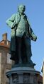
Statue of Denis Diderot
- Langres - Maison Renaissance 2.jpg
Renaissance period mansion
- Langres - maison renaissance rue Saint Didier.jpg
Renaissance period mansion
- Langres - Square Claude-Henriot 2.jpg
Henriot Square
- Langres - église Saint-Martin 2.jpg
Saint-Martin Church

References
- ^ "Répertoire national des élus: les maires" (in الفرنسية). data.gouv.fr, Plateforme ouverte des données publiques françaises. 13 سبتمبر 2022.
- ^ Génin, M.F. (1862). Œuvres choisies de Diderot, précédées de sa vie [Selected Works of Diderot, Prefaced with his Biography] (in الفرنسية). Paris: Librairie de Firmin Didot Frères, Fils et Compagnie.
- ^ "Maison des Lumières Denis Diderot | Musées de Langres - Maison des Lumières Denis Diderot - Musée d'Art et d'Histoire". www.musees-langres.fr. Retrieved 24 يناير 2022.
- ^ Population en historique depuis 1968, INSEE
- ^ "Normales et records pour Langres (52)". Meteociel. Retrieved 21 نوفمبر 2024.
- ^ "Normes et records 1961-1990: Langres (52) - altitude 467m" (in الفرنسية). Infoclimat. Retrieved 31 ديسمبر 2015.
- ^ "British towns twinned with French towns". Archant Community Media Ltd. Archived from the original on 5 يوليو 2013. Retrieved 11 يوليو 2013.
External links
- Catholic Encyclopedia: Diocese of Langres
- Langres official website (in French)
| International | |
|---|---|
| National | |
- Pages using gadget WikiMiniAtlas
- CS1 الفرنسية-language sources (fr)
- Use dmy dates from August 2023
- Short description is different from Wikidata
- Coordinates on Wikidata
- Pages using infobox settlement with image map1 but not image map
- Pages with فرنسية IPA
- Pages including recorded pronunciations
- Articles with unsourced statements from January 2008
- Communes of Haute-Marne
- مراكز الدوائر الادارية في فرنسا
- Lingones
- Gallia Lugdunensis
- Champagne (province)