لونگجي Longji
Longji Town
龙脊镇 | |
|---|---|
 Longji Rice Terraces. | |
 Longji Town Location in Guangxi | |
| الإحداثيات: 25°43′54″N 110°03′47″E / 25.73167°N 110.06306°E | |
| البلد | الصين |
| المنطقة الذاتية | Guangxi |
| المحافظة | Guilin |
| الناحية الذاتية | Longsheng Various Nationalities Autonomous County |
| المساحة | |
| • الإجمالي | 273٫34 كم² (105٫54 ميل²) |
| التعداد (2018) | |
| • الإجمالي | 16٬000 |
| • الكثافة | 59/km2 (150/sq mi) |
| منطقة التوقيت | UTC+08:00 (China Standard) |
| Postal code | 541701 |
| مفتاح الهاتف | 0773 |
لونگجي ( Longji ؛ الصينية المبسطة: 龙脊镇; الصينية التقليدية: 龍脊鎮; پنين: Lóngjí Zhèn) is a town in Longsheng Various Nationalities Autonomous County, Guangxi, China.[1] As of the 2018 census it had a population of 16,000 and an area of 273.34-متر-كيلومربع (105.54 sq mi). Longji is known worldwide for Longsheng Rice Terraces.

التقسيمات الإدارية
As of 2016, the town is divided into fifteen villages and one community:
- Heping Community (和平社区)
- Heping (和平村)
- Daliu (大柳村)
- Baishui (白水村)
- Yueqiao (岳武村)
- Bailing (摆岭村)
- Baishi (白石村)
- Jinjiang (金江村)
- Longji (龙脊村)
- Ping'an (平安村)
- Huangjiang (黄江村)
- Mahai (马海村)
- Zhongliu (中六村)
- Dazhai (大寨村)
- Xiaozhai (小寨村)
- Jiangliu (江柳村)
التاريخ
Longji came under the jurisdiction of Yining County (义宁县) in the Qing dynasty (1644–1911).
In 1916, it belonged to the South District (南区). In 1933, it was under the jurisdiction of Zhennan Township (镇南乡).
It known as Guanya Township (官衙乡) in May 1952 and renamed "Heping Township" on December 26 of that same year. On August 30, 1958, Heping Commune was founded and was revoked in August 1984. On January 2, 2014, it was upgraded to a town.
الجغرافيا
The town is situated at southeastern Longsheng Various Nationalities Autonomous County. The town is bordered to the north by Sishui Township, to the northeast by Jiangdi Township, to the south by Lingui District. to the southeast by Lingchuan County, and to the west by Longsheng Town.
The highest point in the town is Fupingbao (الصينية: 福平包) which stands 1،916.4 متر (6،287 ft) above sea level. The lowest point is Lipai (الصينية: 里排), which, at 238 متر (781 ft) above sea level.
The Heping Stream (和平河), a tributary of the Xun River, winds through the town.
الاقتصاد
Tourism is a significant part of the economy. The region abounds with gold.
المعالم السياحية
The Longsheng Rice Terraces is a famous scenic spot in China.
النقل
The China National Highway 321, commonly referred to as "G321", is a north–south highway passing through the town.
The G65 Baotou–Maoming Expressway, more commonly known as "Bao-Mao Expressway", runs north to south of the town.
معرض صور
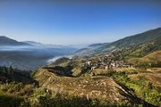
Longsheng Rice Terraces
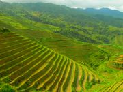
Longsheng Rice Terraces
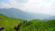
Longsheng Rice Terraces
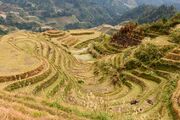
Longsheng Rice Terraces in November 2017.


المراجع
- ^ Yang Tongming 2007, pp. 13-21.
ببليوجرافيا
- Yang Tongming, ed. (2007). "Administrative divisions" 行政区划. 《龙胜各族自治县概况》 [General Situation of Longsheng Various Nationalities Autonomous County] (in الصينية). Beijing: Nationalities Publishing House. ISBN 978-7-105-08630-6.