مقاطعة پالو پنتو، تكساس
Palo Pinto County | |
|---|---|
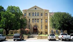
 محكمة مقاطعة پالو پنتو في پالو پنتو. المبنى بالحجر الجيري أضيف إلى السجل الوطني للأماكن التاريخية في 1997. | |
|
Flag | |
 الموقع ضمن ولاية Texas | |
 موقع Texas ضمن الولايات المتحدة | |
| الإحداثيات: 32°45′N 98°19′W / 32.75°N 98.31°W | |
| البلد | |
| State | |
| تأسست | 1857 |
| السمِيْ | غدير پالو پنتو |
| أكبر مدينة | Mineral Wells |
| المساحة | |
| • الإجمالي | 986 ميل² (2٬550 كم²) |
| • البر | 952 ميل² (2٬470 كم²) |
| • الماء | 34 ميل² (90 كم²) 3.4%% |
| التعداد (2010) | |
| • الإجمالي | 28٬111 |
| • الكثافة | 30/sq mi (10/km2) |
| منطقة التوقيت | UTC−6 (Central) |
| • الصيف (التوقيت الصيفي) | UTC−5 (CDT) |
| Congressional district | 11th |
| الموقع الإلكتروني | www |
مقاطعة پالو پنتو إنگليزية: Palo Pinto County هي إحدى المقاطعات في ولاية تكساس، الولايات المتحدة. وفي تعداد 2010 بلغ عدد سكانها 28,111 نسمة.[1] مقر المقاطعة هو پالو پنتو.[2] أنشِئت المقاطعة في 1856 ونـُظـِّمت في العام التالي.[3]
تضم مقاطعة پالو پنتو Mineral Wells, TX Micropolitan Statistical Area, which is part of the Dallas–Fort Worth, TX Combined Statistical Area. It is located in the Western Cross Timbers Ecoregion.
التاريخ
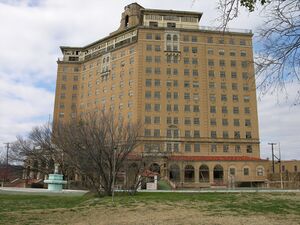
 فندق بيكر المهجور في منرال ولز |
الأمريكان الأصليون
The Brazos Indian Reservation, founded by General Randolph B. Marcy in 1854, provided a safety area from warring Comanche for Delaware, Shawnee, Tonkawa, Wichita, Choctaw, and Caddo. Within the reservation, each tribe had its own village and cultivated agricultural crops. Government-contracted beef cattle were delivered each week. Citizens were unable to distinguish between reservation and nonreservation tribes, blaming Comanche and Kiowa depredations on the reservation Indians. A newspaper in Jacksboro, Texas, titled The White Man advocated removal of all tribes from North Texas.[4][5]
During December 1858, Choctaw Tom, who was a Yowani married to a Hasinai woman, who was at times an interpreter to Sam Houston, and a group of reservation Indians received permission for an off-the-reservation hunt. On December 27, Captain Peter Garland and a vigilante group charged Choctaw Tom's camp, indiscriminately murdering and injuring women and children along with the men. .[6]
التجمعات
المدن
- Gordon
- Graford
- Mineral Wells (partly in Parker County)
- Mingus
- Strawn
مكان مخصص بالإحصاء
- Palo Pinto (مقر المقاطعة)
تجمعات أخرى غير مشهرة
أشخاص بارزون
- Steve Tyrell, singer and recording artist
السياسة
| Year | Republican | Democratic | Third parties |
|---|---|---|---|
| 2016 | 80.7% 8,284 | 16.6% 1,708 | 2.7% 278 |
| 2012 | 79.1% 7,393 | 19.4% 1,811 | 1.6% 147 |
| 2008 | 73.5% 7,264 | 25.3% 2,499 | 1.3% 127 |
| 2004 | 71.3% 7,137 | 28.1% 2,816 | 0.6% 61 |
| 2000 | 62.4% 5,690 | 35.8% 3,263 | 1.8% 165 |
| 1996 | 42.4% 3,666 | 45.5% 3,938 | 12.1% 1,051 |
| 1992 | 30.8% 2,852 | 36.6% 3,392 | 32.7% 3,031 |
| 1988 | 53.9% 4,649 | 45.5% 3,930 | 0.6% 55 |
| 1984 | 62.8% 5,701 | 36.9% 3,349 | 0.3% 27 |
| 1980 | 48.0% 4,068 | 50.0% 4,244 | 2.0% 172 |
| 1976 | 34.0% 2,684 | 65.4% 5,170 | 0.7% 51 |
| 1972 | 69.8% 5,058 | 30.1% 2,181 | 0.1% 8 |
| 1968 | 35.3% 2,627 | 47.8% 3,552 | 16.9% 1,257 |
| 1964 | 31.6% 1,748 | 68.4% 3,791 | 0.0% 2 |
| 1960 | 46.9% 2,695 | 52.6% 3,022 | 0.4% 25 |
| 1956 | 54.2% 2,818 | 45.6% 2,369 | 0.2% 12 |
| 1952 | 51.2% 3,029 | 48.6% 2,876 | 0.2% 12 |
| 1948 | 19.4% 977 | 74.1% 3,736 | 6.6% 332 |
| 1944 | 10.1% 416 | 79.8% 3,291 | 10.2% 419 |
| 1940 | 16.5% 510 | 83.2% 2,571 | 0.3% 9 |
| 1936 | 11.9% 371 | 87.7% 2,738 | 0.5% 14 |
| 1932 | 12.5% 392 | 87.0% 2,722 | 0.5% 14 |
| 1928 | 63.3% 2,001 | 36.7% 1,161 | |
| 1924 | 18.0% 473 | 73.2% 1,926 | 8.8% 232 |
| 1920 | 15.8% 342 | 75.7% 1,645 | 8.5% 185 |
| 1916 | 6.7% 124 | 77.4% 1,431 | 15.9% 293 |
| 1912 | 3.8% 68 | 69.3% 1,231 | 26.9% 478 |
انظر أيضاً
- National Register of Historic Places listings in Palo Pinto County, Texas
- Recorded Texas Historic Landmarks in Palo Pinto County
المراجع
- ^ "State & County QuickFacts". United States Census Bureau. Archived from the original on October 18, 2011. Retrieved December 22, 2013.
- ^ "Find a County". National Association of Counties. Retrieved 2011-06-07.
- ^ "Texas: Individual County Chronologies". Texas Atlas of Historical County Boundaries. The Newberry Library. 2008. Retrieved May 26, 2015.
- ^ Crouch, Carrie J: Brazos Indian Reservation from the Handbook of Texas Online. Retrieved 05 May 2010. Texas State Historical Association.
- ^ Minor, David: White Man from the Handbook of Texas Online. Retrieved 05 May 2010. Texas State Historical Association.
- ^ "Choctaw Tom". Fort Tours. Retrieved 5 May 2010.
- ^ Leip, David. "Dave Leip's Atlas of U.S. Presidential Elections". uselectionatlas.org. Retrieved 8 April 2018.
وصلات خارجية
- Palo Pinto County government's website
- Historic Palo Pinto County materials hosted by the Portal to Texas History
- Palo Pinto County from the Handbook of Texas Online
32°45′N 98°19′W / 32.75°N 98.31°W{{#coordinates:}}: لا يمكن أن يكون هناك أكثر من وسم أساسي واحد لكل صفحة

|
مقاطعة جاك | مقاطعة ينگ | 
| |
| مقاطعة پاركر | مقاطعة ستيفنز | |||
| مقاطعة هود | مقاطعة إيراث | مقاطعة إيستلاند |
- Pages using gadget WikiMiniAtlas
- صفحات ذات وسوم إحداثيات غير صحيحة
- Short description is different from Wikidata
- Pages using infoboxes with URL in image parameter
- Coordinates on Wikidata
- مقاطعات Texas
- Articles containing إنگليزية-language text
- Pages using Lang-xx templates
- Pages with empty portal template
- مقاطعة پالو پنتو، تكساس
- مقاطعات تكساس
- أماكن مأهولة تأسست في 1857
