نقاش الوحدة:Syrian and Iraqi insurgency detailed map/testcases


al-Aziziyah
Ehtimilat
Al Zarieh
Duwaybiq
Arshaf
Hecine
Tell al-Hamad
Tell Mutawwaq al-Kabeer


Wael
#no
[[File:map-dot-grey-68a.svg|6x6px|قميناس|link=class=notpageimage
[[File:map-dot-grey-68a.svg|10x10px|سلقين|link=Cities and towns during the Syrian Civil War#سلقين|class=notpageimage]]
#no
Al Kasik Military Base
Camp Numaan
Bai Hassan oil field
Kirkuk oil field
Gypsum Plant
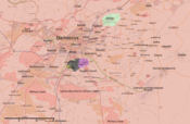
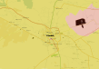
Hold cursor over location to display name; click to go to location row in the "table of cities and towns" (if available).
Control : Government ;
  main rebels ;
  Kurds ;
  al-Nusra Front (JaN) ;
  Islamic State (IS) ;
  Local tribe
 ميناء رئيسي أو قاعدة بحرية ؛
  نقطة حدودية ؛
  سد ؛
سد ؛  مجمع صناعي
2 nested circles: inner controls, outer sieges (or indicates strong enemy pressure) // 3 nested circles: mixed control with stable situation
Small icons within large circle: situation in individual neighbourhoods/districts
Control :
Rural presence : ![]()
![]() ملف:3x3dot-yellow.svg
ملف:3x3dot-yellow.svg ![]()
![]()
![]()
![]()
![]()
![]()
![]()
Contested : ![]() Gov't/main_rebels ;
Gov't/main_rebels ; ![]() gov't/kurds ;
gov't/kurds ; ![]() gov't/JaN ;
gov't/JaN ; ![]() gov't/IS ;
gov't/IS ; ![]() main_rebels/kurds ; ملف:80x80-lime-grey-anim.gif main_rebels/JaN ;
main_rebels/kurds ; ملف:80x80-lime-grey-anim.gif main_rebels/JaN ; ![]() main_rebels/IS ;
main_rebels/IS ; ![]() kurds/JaN ;
kurds/JaN ; ![]() kurds/IS ; ملف:80x80-red-lime-yellow-anim.gif 3-way ;
kurds/IS ; ملف:80x80-red-lime-yellow-anim.gif 3-way ;
Besieged_one_side : ![]()
![]()
![]()
![]()
![]()
![]()
![]()
![]()
![]()
![]()
![]()
![]()
![]()
![]()
![]()
![]()
![]()
![]()
![]()
![]()
![]()
![]()
![]()
![]()
![]()
![]()
![]()
![]()
![]()
![]()
![]()
![]()
![]()
![]()
![]()
![]()
![]()
![]()
![]()
![]()
Besieged : ![]()
![]()
![]()
![]()
![]() Military base :
Military base : ![]()
![]()
![]()
![]()
![]() Airport/Air base (plane) :
Airport/Air base (plane) : ![]()
![]()
![]()
![]()
![]() Heliport/Helicopter base :
Heliport/Helicopter base : ![]()
![]()
![]()
![]()
![]()
2 nested circles: inner controls, outer sieges (or indicates strong enemy pressure) // 3 nested circles: mixed control with stable situation
Small icons within large circle: situation in individual neighbourhoods/districts