نهر خرامي
| Khrami آذربيجاني: Anaxatır | |
|---|---|
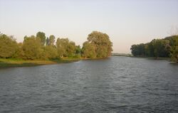
 The Khrami near Kirach Muganlo, Georgia | |
 | |
| الاسم المحلي | Error {{native name}}: an IETF language tag as parameter {{{1}}} is required (help) |
| الموقع | |
| Countries | Georgia and Azerbaijan |
| Region | Caucasus |
| السمات الطبيعية | |
| المنبع | Lesser Caucasus |
| ⁃ الموقع | Trialeti Range, جورجيا |
| المصب | Kura |
- الموقع | Muğanlı, Agstafa, Azerbaijan |
- الإحداثيات | 41°18′55″N 45°07′31″E / 41.31528°N 45.12528°E |
| الطول | 201 km (125 mi) |
| التدفق | |
| ⁃ الموقع | directly downstream into Kura |
| سمات الحوض | |
| السريان | كورا ← بحر قزوين |
| الروافد | |
| - اليسرى | Debed, Mashavera |
 | |
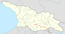
خرامي (Khrami ؛ بالجورجية: ხრამი, آذربيجاني: Anaxatır "أناخاطر")، في أعاليه Ktsia، هو نهر في شرق جورجيا وغرب أذربيجان, and a right tributary of the Kura (Mtkvari). It is 201 km (125 mi) long, and has a drainage basin of 8،340 km2 (3،220 sq mi).[1][2] The Khrami originates in the Trialeti Range and flows into a deep valley. It is fed primarily by snow. Its main tributaries are the Debed and Mashavera rivers. The Tsalka Reservoir and three hydroelectric power plants are built on the Khrami.
انظر أيضاً
المراجع
- ^ Statistical Yearbook of Georgia: 2020, National Statistics Office of Georgia, Tbilisi, 2020, p. 12.
- ^ Храми, Great Soviet Encyclopedia
This article may include material from Wikimedia licensed under CC BY-SA 4.0. Please comply with the license terms.
تصنيفات:
- Pages using gadget WikiMiniAtlas
- Short description is different from Wikidata
- Articles containing آذربيجاني-language text
- Pages using Lang-xx templates
- Native name template errors
- Coordinates on Wikidata
- روافد نهر كورا (بحر قزوين)
- Articles containing جورجية-language text
- Rivers of Georgia (country)
- Rivers of Azerbaijan
- International rivers of Asia
- أنهار دولية في أوروپا
- صفحات مع الخرائط