نهر شاري
| نهر شاري | |
|---|---|
 نهر شاري | |
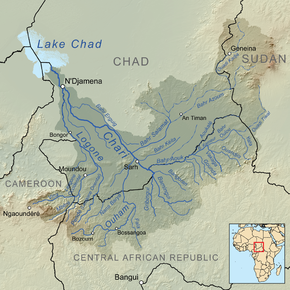
 Map showing the Chari River drainage basin. | |
خطأ: إحداثيات غير صالحة. | |
| الاسم المحلي | Error {{native name}}: an IETF language tag as parameter {{{1}}} is required (help) |
| الموقع | |
| Countries | Central African Republic, Chad, Cameroon |
| السمات الطبيعية | |
| المنبع | Bamingui |
| ⁃ الموقع | Mbolo, Central African Republic |
| ⁃ الإحداثيات | 7°22′55″N 20°57′47″E / 7.382°N 20.963°E |
| ⁃ المنسوب | 549 m (1،801 ft) |
| 2nd source | Gribingui |
| ⁃ الموقع | Mbrès, Central African Republic |
| ⁃ الإحداثيات | 6°40′23″N 19°49′55″E / 6.673°N 19.832°E |
| ⁃ المنسوب | 631 m (2،070 ft) |
| المصب | Lake Chad |
- الموقع | Kinziyakeu, Cameroon |
- الإحداثيات | 12°58′41″N 14°30′43″E / 12.978°N 14.512°E |
- المنسوب | 281 m (922 ft) |
| الطول | 1،400 km (870 mi) |
| مساحة الحوض | 548،747 km2 (211،872 sq mi) |
| التدفق | |
| ⁃ الموقع | N'djamena |
| ⁃ المتوسط | 1059 m3/s[1] |
| ⁃ أدنى تدفق | 8 m3/s[1] |
| ⁃ أقصى تدفق | 4846 m3/s[1] |
| سمات الحوض | |
| الروافد | |
| - اليسرى | Logone River |
| خطأ: الوظيفة "main" غير موجودة. | |
نهر شاري في وسط أفريقيا يبلغ طوله 949 كيلومترا. ينبع من جمهورية أفريقيا الوسطى ويمر عبر تشاد ليصب في بحيرة تشاد الكبرى، متتبعاً حدود الكامرون من نجامينا حيث يلتحم مع نهر لوگونه.
معظم سكان تشاد بما فيهم سكان صرح والعاصمة نجامينا يتركزون حول هذا النهر. ويغذي نهر شاري بحيرة تشاد بنحو 90% من مياهها. وتبلغ مساحة حوض تصريف النهر حوالي 548,747 كم².
الجغرافيا
The Chari River flows from the Central African Republic through Chad into Lake Chad, following the Cameroon border from N'Djamena, where it is joined by its western and principal tributary, the Logone River.
It provides 90 percent of the water flowing into Lake Chad. The watershed of the river covers 548،747 متر كيلومربع (211،872 sq mi). The principal tributary is the Logone River, while minor tributaries include the Bahr Salamat, Bahr Sah, Bahr Aouk and Bahr Kéita.
Much of Chad's population, including Sarh and the capital N'Djamena, is concentrated around it.
As of 2016, Chad remains one of four countries where Guinea worm disease remains endemic. The majority of remaining cases are concentrated around the Chari River.
The river supports an important local fishing industry. One of the most highly prized local fish is the Nile perch.
Since the 1960s, there have been proposals to divert water from the Ubangi River to the Chari to revitalize Lake Chad, which would constitute a reversal of the capture of the upper Ubangi from the Chari by the Congo River that is believed to have occurred in the early Pleistocene.[2]
التاريخ
The Sao people are said to have lived by this river.[3]
The Chari River basin has been populated by diverse speakers of the Chadic languages, Adamawa languages, Ubangian languages, Bongo-Bagirmi languages.
انظر أيضاً
المصادر
- ^ أ ب ت "GRDC station information for Njamena (Fort Lamy)".
- ^ See Cooper, John E. and Hull, Gordon; Gorilla Pathology and Health: With a Catalogue of Preserved Materials, p. 371 ISBN 9780128020395
- ^ Li, Ying; Trillo, E. A.; Murr, L. E. (2000). "Friction-stir welding of aluminum alloy 2024 to silver". Journal of Materials Science Letters. 19 (12): 1047–1051. doi:10.1023/a:1006795221194. ISSN 0261-8028. S2CID 135070501.[المصدر لا يؤكد ذلك]
وصلات خارجية
| هذا متعلقة بتشاد article هو بذرة. بإمكانك مساعدة المعرفة بأن تنمـِّـيـه. |
- مقالات ذات عبارات بحاجة لمصادر
- Short description is different from Wikidata
- Native name template errors
- Pages using gadget WikiMiniAtlas
- نهر شاري
- أنهار جمهورية أفريقيا الوسطى
- أنهار تشاد
- أنهار الكامرون
- أنهار أفريقيا
- أنهار دولية في أفريقيا
- بحيرة تشاد
- حدود تشاد-كاميرون
- بذرة مياه
- قالب بذرة تشاد
- All stub articles
- بذور تشاد
