ناحية ژونگبا Zhongba County
ناحية ژونگبا
仲巴县 • འབྲོང་པ་རྫོང་། Drongpa | |
|---|---|
| Zhongba County | |
 | |
.png&filetimestamp=20231209095147&) Location of Zhongba County (red) in Xigazê City (yellow) and the Tibet A.R. | |
 ژونگبا Location of the seat in the Tibet A.R.  ژونگبا ژونگبا (الصين) | |
| الإحداثيات: 29°46′12″N 84°01′53″E / 29.77000°N 84.03139°E | |
| البلد | الصين |
| المنطقة الذاتية | التبت |
| المدينة بمستوى محافظة | شيگاتسى |
| County seat | لابرانگ (درونگپا) |
| المساحة | |
| • الإجمالي | 43٬602٫92 كم² (16٬835٫18 ميل²) |
| التعداد (2020)[1] | |
| • الإجمالي | 26٬897 |
| • الكثافة | 0٫62/km2 (1٫6/sq mi) |
| منطقة التوقيت | UTC+8 (China Standard) |
| الموقع الإلكتروني | www |
| ناحية ژونگبا | |||||||
|---|---|---|---|---|---|---|---|
| Chinese name | |||||||
| الصينية المبسطة | 仲巴县 | ||||||
| الصينية التقليدية | 仲巴縣 | ||||||
| |||||||
| Tibetan name | |||||||
| Tibetan | འབྲོང་པ་རྫོང་། | ||||||
| |||||||
ناحية ژونگبا Drongpa County[2][3] or Zhongba County[4] (التبتية: འབྲོང་པ་རྫོང; الصينية: 仲巴县) is a county of Shigatse Prefecture in China's Tibet Autonomous Region. Located in the western part of Central Tibet (sometimes referred to as "western Tibet"), it is the birthplace of the Tsangpo River (Brahmaputra).[5] Zhongba is said to mean "place of wild yaks" in Tibetan. مقر الناحية هو في لابرانگ، والتي تُدعى أيضاً "بلدية درونگپا".
الجغرافيا
Drongpa County is the largest county in the Shigatse Prefecture by geographical area.[6] It has a population of approximately 18,000 and covers 43,594 square kilometers. It is prone to earthquakes and suffered a large one, 6.8 on the Richter scale, on 30 August 2008. Although the temblor left a 10 km (6.2 mi) north-south crack at the epicenter located at 31° north and 83.6° east, and houses were damaged and roads blocked by falling rocks, there were no reported injuries.[7] The county is dotted with lakes such as Taro Tso, Nganglha Ringtso and Rinchen Shubtso.
Drongpa County shares the Tibet Autonomous Region's southern border with most of western Nepal's Karnali and Dhaulagiri Zones with a border crossing into Mustang District leading through the former Lo Kingdom to its historic capital Lo Manthang.
التقسيمات الإدارية
تنقسم ناحية ژونگبا إلى بلدة واحدة و 12 بلدية.
| الاسم | Chinese | Hanyu Pinyin | Tibetan | Wylie | ||
|---|---|---|---|---|---|---|
| البلدة | ||||||
| Baryang Town (Paryang) |
帕羊镇 | Pàyáng zhèn | བར་ཡངས་གྲོང་རྡལ། | bar yangs grong rdal | ||
| Townships | ||||||
| Labrang Township (Drongpa) |
拉让乡 | Lāràng xiāng | ལ་བྲང་ཤང་། | la brang shang | ||
| Qonkor Township | 琼果乡 | Qióngguǒ xiāng | ཆོས་འཁོར་ཤང་། | chos 'khor shang | ||
| Yagra Township | 亚热乡 | Yàrè xiāng | ཡག་ར་ཤང་། | yag ra shang | ||
| Bodoi Township | 布多乡 | Bùduō xiāng | སྤོ་སྟོད་ཤང་། | spo stod shang | ||
| Penchi Township | 偏吉乡 | Piānjí xiāng | ཕན་ཕྱི་ཤང་། | phen phyi shang | ||
| Nagqu Township | 纳久乡 | Nàjiǔ xiāng | ནག་ཆུ་ཤང་། | nag chu shang | ||
| Gêla Township | 吉拉乡 | Jílā xiāng | སྐེད་ལ་ཤང་། | sked la shang | ||
| Horpa Township | 霍尔巴乡 | Huò'ěrbā xiāng | ཧོར་པ་ཤང་། | hor pa shang | ||
| Lunggar Township | 隆嘎尔乡 | Lónggā'ěr xiāng | ལུང་དཀར་ཤང་། | lung dkar shang | ||
| Gyêma Township | 吉玛乡 | Jímǎ xiāng | སྐྱེ་མ་ཤང་། | skye ma shang | ||
| Rintor Township | 仁多乡 | Rénduō xiāng | རི་འཐོར་ཤང་། | ri 'thor shang | ||
| Barma Township (Pama) |
帕江乡 | Pàjiāng xiāng | བར་མ་ཤང་། | bar ma shang | ||
خرائط
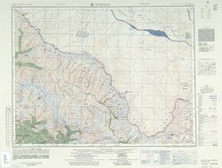
Map showing "Matsang" and the southern portion bordering Nepal (AMS, 1954)
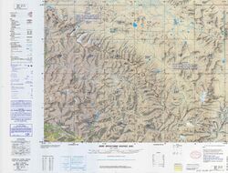
Map showing "Matsang" and the southern portion bordering Nepal (DMA, 1985)


النقل
المراجع
- ^ "日喀则市第七次全国人口普查主要数据公报" (in الصينية). Government of Xigazê. 2021-07-20.
- ^ Tibet 2002: A Year Book, Tibet Information Network, London, p. 145.
- ^ Dorje, Footprint Tibet (2004), p. 334.
- ^ Jianglin Li (2022). When the Iron Bird Flies: China's Secret War in Tibet. Stanford University Press. p. 245. ISBN 978-1-5036-2979-0.
- ^ Dorje, Footprint Tibet (2004), p. 256.
- ^ Croddy, E. (2022). China’s Provinces and Populations: A Chronological and Geographical Survey. Springer International Publishing. p. 698. ISBN 978-3-031-09165-0. Retrieved 2024-03-07.
- ^ "Strong earthquake in Tibet leaves no casualties, but big crack". Xinhua News Agency. 2008-08-30. Archived from the original on 2016-03-04.
ببليوجرافيا
- Dorje, Gyurme (2004), Footprint Tibet Handbook with Bhutan (3rd ed.), Bath: Footprint Handbooks, ISBN 1-903471-30-3, https://archive.org/details/footprinttibet0000dorj
قالب:Xigaze Prefecture قالب:Towns in Xigazê قالب:China–Nepal border crossings
- Pages using gadget WikiMiniAtlas
- CS1 الصينية-language sources (zh)
- Short description is different from Wikidata
- Articles containing صينية-language text
- Coordinates on Wikidata
- مقالات تحتوي نصوصاً باللغة التبتية
- Articles containing simplified Chinese-language text
- نواحي شيگاتسى
- المعابر الحدودية بين الصين ونـِپال
- ناحية ژونگبا