الساحل، أرض الصومال
الساحل
| |
|---|---|
 | |
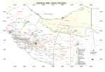
 موقع الساحل في أرض الصومال. | |
| البلد | |
| المركز الإداري | بربرة |
| الحكومة | |
| • الحاكم | Cali Cabdi Cabdillaahi Faarax |
| المساحة | |
| • الإجمالي | 13٬930 كم² (5٬380 ميل²) |
| منطقة التوقيت | UTC+3 (ت.ش.أ.) |
الساحل (صومالية: Saaxil)، هي إحدى مناطق أرض الصومال، وعاصمتها بربرة. It was separated from Woqooyi Galbeed and became a province in 1991. In 1998, the Sheikh District of Togdheer was incorporated into Sahil region.[1] The region has a long coastline facing the Gulf of Aden to the north. Sahil borders Awdal to the northwest, Maroodi Jeex to the southwest, Togdheer to the south and Sanaag to the east.
التاريخ
Formerly known as the Berbera District, it was one of six districts that made up the British Somaliland protectorate. In 1960, the then independent State of Somaliland merged with Italian Somaliland to form the Somali Republic. By 1964, the then Berbera District merged with the Borama district (now Awdal) and the Hargeisa district (now Maroodi Jeh) to form the Woqooyi Galbeed region (literally North West, also known as Hargeisa region).
During the period from 1968 to 1982, parts of the district were incorporated into Togdheer region. Awdal was carved out of the western parts of Woqooyi Galbeed region in June 1984.[2] However, Sahil was the only of the six former British territories to be rebuilt during the Somali government's reign.
When the Somali Civil War broke out, the former British territory declared the revival of the pre-independent state of Somaliland. In December 1989, the Somaliland government established Sahil region. In 1998, the Sheikh District was incorporated from Togdheer. Under the Local Autonomy Act of 2002, it was positioned as one of the six regions that make up Somaliland.[3]
The Somaliland was reorganized on March 22, 2008, and the territory of Sahil was changed. However, a new local government law came into force on January 4, 2020, and the territory was restored.[4]
المقاطعات

The regional capital of the Sahil region is the port city of Berbera. The region is further divided into the following two districts:[5]
| المقاطعة | الدرجة | العاصمة | ملاحظات | الموقع |
|---|---|---|---|---|
| بربرة | أ | بربرة | عاصمة المنطقة | .svg&filetimestamp=20251228162241&)
|
| الشيخ | ج | الشيخ | .svg&filetimestamp=20251228162240&)
|
الديموغرافيا
According to the Somaliland Ministry of National Planning Sahil had a population of 149,244 in 1997.[6]
The region is inhabited by the Issa Musse include sub-clan of the Habr Awal,[7] who are the majority of inhabitants. Minorities include, the Habr Yunis, primarily belonging to the Musa Abdallah branch, the Habr Je'lo as well as the Abdallah Arap, all clans of the wider Isaaq clan-family.[8][9]
خريطة
- خريطة منطقة الساحل

انظر أيضاً
المصادر
- ^ "Local Government Law".
- ^ "Somalia Regions".
- ^ "Local Government Law".
- ^ "Wax-ka-beddelka iyo Kaabista Xeerka Ismaamulka Gobolladda iyo Degmooyinka, Xeer Lr. 23/2019" (PDF). Somaliland Law.
- ^ "Development plan" (PDF). slministryofplanning.org. Retrieved 2021-01-11.
- ^ United Nations Office for Somalia, (UNDOS) (1997). "WAQOOYI GALBEED AND SAHIL". Archived from the original on 2001-06-30.
- ^ Center for Creative Solutions (May 31, 2004), Ruin and Renewal: The Story of Somaliland, Hargeisa: Center for Creative Solutions, http://www.mbali.info/doc124.htm, retrieved on September 21, 2010, "The ‘Iise Muuse clan for whom Berbera and its environs are their traditional area of settlement saw it differently. Retrieved on 2011-12-15."
- ^ Kluijver, Robert. "KYD3 - Politics in Berbera". Politics and Art from the Edge (in الإنجليزية الأمريكية). Archived from the original on 2022-01-02. Retrieved 2022-01-02.
- ^ Hunt, John Anthony (1951). A General Survey of the Somaliland Protectorate 1944-1950: Final Report on "An Economic Survey and Reconnaissance of the British Somaliland Protectorate 1944-1950," Colonial Development and Welfare Scheme D. 484 (in الإنجليزية). To be purchased from the Chief Secretary.