مناطق أرض الصومال
| ||||||||||||||||||||
| ||||||||||||||||||||


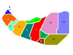
مناطق أرض الصومال (صومالية: Gobolada Somaliland؛ إنگليزية: regions of Somaliland)، هي المناطق الإدارية الستة المكونة لجمهورية أرض الصومال، وهي: أودل، الساحل، مرودي جيح، توجدير، سناج، وصول. تنقسم هذه المناطق بدورها إلى 22 مقاطعة. مناطق أرض الصومال هي التقسيمات الجغرافية الأسياسية لأرض الصومال، وتقُسم المقاطعات إلى أربع درجات، أ، ب، ج، د، تبعاً لعدد السكان، المساحة، الاقتصاد، والإنتاج.[1]
المناطق
| الترتيب | الموقع | المناطق | المساحة (كم2) | العاصمة | المقاطعات |
|---|---|---|---|---|---|
| 1 |  |
أودل | 21,374 | بورمه | باكي، بورمه، زيلع، لودجيا |
| 2 |  |
الساحل | 13,930 | بربرة | الشيخ، بربرة |
| 3 |  |
مرودي جيح | 17,429 | هرگيسة | قبلي، هرگيسة |
| 4 |  |
توجدير | 30,426 | بورعو | أودويني، بوهودلى، بورعو |
| 5 |  |
سناج | 54,231 | عيرقابو | عيل أفوين، عيرقابو، لاسكوري |
| 6 |  |
صول | 39,240 | لاسعانود | عينبة، لاسعانود، تليح، حدن |
التاريخ
المحمية البريطانية وفترة الاستقلال
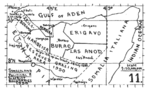
The local administration of British Somaliland (1884-June 26, 1960) was stipulated primarily by the Local Government Ordinance of 1953.[2] The ordinance established councils in six districts that had divided [3] Somaliland since 1944. The ordinance continued to be used after independence as the State of Somaliland (June 26-July 1, 1960). At the time of the integration with Italian Somaliland on July 1, 1960, there were the following six districts.[4]
- Berbera
- Borama
- Burao
- Erigavo
- Hargeisa
- Las Anod
The council (capital) was located in the city of the same name. These six areas were inherited by the regions established after the reindependence in 1991, and have a six-regionsystem with the six cities where the council was located as the capital.
- Districts of British Somaliland and latter State of Somaliland

فترة الاتحاد
On July 1, 1960, the State of Somaliland annexed Italian Somaliland and became independent again as the Somali Republic. From then on, the former British territory is called the "northern region" and the former Italian territory with the capital Mogadishu is called the "southern region"[citation needed]. On June 14, 1962, the six former British territories were reorganized into two states.[5] The six districts that made up the former Italian territory have been transferred to the state as they are.
- Burao region (North East region): Erigavo, Burao and Las Anod merged. It has a population of 330,000 (estimated in 1961) and an area of 128,000 square kilometers.
- Hargeisa region (North West region): Berbera, Borama and Hargeisa districts merged. It has a population of 270,000 (same as above) and an area of 48,000 square kilometers.
Subsequently, the "Local Administration and Local Assembly Election Act" was enacted on August 14, 1963, and a district (District, different from that of the British territory) council was established.[6] A decree governing region and district organization on February 8, 1967 established a two-tiered region-district structure.[7]
On October 21, 1969, a military coup by Maj. Gen. Mohammed Siad Barre broke out. Barre, who seized power, placed all local governments, including regions and districts, under the direct control of the government under the "Local Government Reform Act" of June 8, 1972,[8] and was a party under the decree of February 3, 1977. He established a local rule system based on dictatorship socialism.[9] By 1982, the Barre administration had reorganized the regions of the country, and the two northern regions were divided into Woqooyi Galbeed, Togdheer, and Sanaag. In June 1984, Awdal was separated from Woqooyi Galbeed, and Sool was separated from Nugal (former Italian territory) [10] (although there is a theory that the addition of these two regions was not implemented [11]). .. During the Ogaden War (1977–1988), the same number of refugees as the population at that time (estimated at 1.3 million) rushed to the northern region, and the governing body was paralyzed.[12]
- Regions of Somali Republic between 1962-1969 and Regions of Somali Democratic Republic 1982-1991
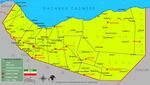
Administrative divisions of Somali Republic in 1969
Administrative divisions of Somali Democratic Republic in 1991


ما بعد الانفصال
The northern regions declared independence from Somali Democratic Republic after a 10 year long war of independence[13] and restoration of sovereignty on May 18, 1991, and the Republic of Somaliland was established. According to the "Decrees Establishing the Structure of the Ministry of Interior and regions / Districts" in 1993, it was divided into 6 regions inherited from the era of Somaliland, 18 districts during the Somali era, and one district created by the Somaliland government, for a total of 19 districts.[14] In addition, provincial assessments were carried out. Twenty-three districts were created by executive order after independence, but nearly all districts were not approved by Parliament for failing to meet district standards. By 1993, it was approved by Parliament and was incorporated into law only in Baligubadle District.
Berbera District in Woqooyi Galbeed became by executive order Sahil, and in 1998 the Sheikh District of Togdheer was incorporated into Sahil.
In 2007, The region of Woqooyi Galbeed was renamed to Maroodi Jeex (Chapter 1, Article 2 [23]. ]).[15]
- Regions of Somaliland between 1991-2008
Administrative divisions of Republic of Somaliland in 1991

2008–2014
Between 22 March and 15 May 2008, then president of Somaliland Dahir Riyale Kahin issued a press statement announcing the creation of six new regions and 16 new districts, in addition to the corresponding administrative divisions already existing as created by Somalia's central government. On May 15, 2008, Kahin released a second statement declaring the Hawd the thirteenth region of Somaliland.[16] In June 2014, Somaliland president Ahmed Mohamed Mohamoud (Ex-president) announced the creation of Somaliland's 14th region, consisting of 4 new districts. The new region, dubbed Haysimo was formed out of the eastern Sool and Sanaag regional districts. It contains the cities of Taleh, Sarmanyo, Godaalo, Hallin, and Aroley. The presidential decree stated that Taleh is the regional capital.[17][18] 8 regions created by President Dahir rayale and Silanyo were not approved by parliament because the new regional boundaries are not clearly demarcated.[19]
- Regions of Somaliland in 2008 and 2014
Administrative divisions of Republic of Somaliland in 2008
Administrative divisions of Republic of Somaliland in 2014


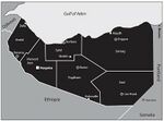
التقسيمات الإدارية الحالية
Currently, Somaliland is divided in 6 regions, Awdal, Sahil, Maroodi-Jeeh, Toghdeer, Sanaag and Sool. This is in accordance with 2 political studies published on Somaliland in 2011 and 2015 and ActionAID, a humanitarian organization currently active in Somaliland.[20][21][22]
In 2019 the local government law passed in 2019 (Lr. 23/2019, hereinafter referred to as the 2019 local government law), regions that "Somaliland is divided into six regions (Article 9 of the same law)".[23] The 2019 Local Government Act came into force on January 4, 2020.[24]
The regional boundaries are supposed to correspond to the boundaries of the six districts under the Somaliland protectorate, however the Siad Barre era boundaries serve as the de facto boundaries. Article 11, section 1 of the amended Local Government Act which came into force in 2020 provides:[25][26]
Xuduudaha Lixda Gobol Ee JSL ka kooban tahay waxay ku salaysan yihiin Xuduudahii ay lahaan jireen lixdii Degmo Ee Waaweynaa Ee jiray xiligii Ingiriiska ka hor 26/06/1960 Ee kala ahaa Hargeysa, Burco, Ceerigaabo, Laascaanood, Boorama iyo Berbera kuwaas oo isku beddelay Gobolladda JSL hadda ka kooban tahay.
- Regions of Somaliland
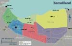
Current administrative divisions

انظر أيضاً
المصادر
- ^ Wax-ka-beddelka iyo Kaabista Xeerka Ismaamulka Gobolladda iyo Degmooyinka somalilandlaw.com
- ^ Somaliland LG Councils Ordinance somalilandlaw.com
- ^ General Survey faoswalim.org
- ^ "Somalia Regions".
- ^ "Somalia Regions".
- ^ LG Local Administration and Local Council Election Laws 1963 somalilandlaw.com/
- ^ LG Organization of Regions. Districts 1967 somalilandlaw.com/
- ^ LG Reform Law 1972 somalilandlaw.com/
- ^ LG Regions. District Law 1977 somalilandlaw.com/
- ^ "Somalia Regions".
- ^ Metz, Helen Chapin, Library Of Congress. Federal Research Division, and Thomas Leiper Kane Collection. Somalia: A Country Study. Washington, D.C.: Federal Research Division, Library of Congress: For sale by the Supt. of Docs., U.S. G.P.O, 1993. Pdf. https://www.loc.gov/item/93016246/. (The corresponding description is Image 21、The map isImage 24)
- ^ Lewis, I. M. (1 January 2008). Understanding Somalia and Somaliland: Culture, History, Society (in الإنجليزية). Hurst. ISBN 978-1-85065-898-6.
- ^ Kapteijns, Lidwien (18 December 2012). Clan Cleansing in Somalia: The Ruinous Legacy of 1991. University of Pennsylvania Press. ISBN 978-0-8122-0758-3.
- ^ "Local Government Law".
- ^ Wuxuu Ansixiyey Xeerkan 23/2002 somalilandlaw.com
- ^ "Madaxweynaha oo Gobol Cusub U Magacaabay Baligubadle". Archived from the original on 7 December 2008.
{{cite web}}: CS1 maint: unfit URL (link) - ^ "Somalia: Somaliland President names historic town of Taleh as New Region". Garowe Online. Archived from the original on 13 February 2020. Retrieved 3 August 2014.
- ^ "Somaliland President Creates New Regions and Districts". www.hiiraan.com.
- ^ "SOMALILAND LOCAL GOVERNMENT LAWS". March 2020. Retrieved 2021-06-19.
- ^ "ActionAid International". actionaid.org.
- ^ State Formation in Somaliland: Bringing Deliberation to Institutionalism. Michael Walls, Planning Unit, UCL February 2011
- ^ "Somaliland: The Strains of Success Crisis Group Africa Briefing N°113 Nairobi/Brussels, 5 October 2015" (PDF). Archived from the original (PDF) on 21 January 2017. Retrieved 9 January 2017.
- ^ 2019 SLLaw somalilandlaw.com/
- ^ "Local Government Law".
- ^ "Local Government Law" (PDF) (in somali). Retrieved 2021-08-24.
{{cite web}}: CS1 maint: unrecognized language (link) - ^ "Local Government Law".
- CS1 maint: unfit URL
- Short description is different from Wikidata
- Portal-inline template with redlinked portals
- Pages with empty portal template
- Articles containing صومالية-language text
- Articles containing إنگليزية-language text
- Articles with unsourced statements from September 2022
- مناطق أرض الصومال
- تقسيمات أرض الصومال
- تقسيمات إدارية في أفريقيا
- تقسيمات ادارية من المستوى الأول لبلد
- قوائم جغرافيا متعلقة بأرض الصومال