الإقليم الشمالي (أستراليا)
Northern Territory | |
|---|---|
Nickname(s):
| |
| [[File:#تحويل قالب:خريطة ولايات أستراليا|250px]] Location of Northern Territory in Australia Coordinates: 20°S 133°E / 20°S 133°E | |
| Country | Australia |
| Established by New South Wales | 1825 |
| Transferred to South Australia | 1863 |
| Transferred to Commonwealth | 1911 |
| Responsible government | 1 July 1978 |
| العاصمة and largest city | Darwin 12°26′17″S 130°50′28″E / 12.43806°S 130.84111°E |
| Administration | 17 local government areas |
| اللغات الشائعة | |
| صفة المواطن | Centralian (Central Australian Region) |
| الحكومة | |
• Monarch | Charles III |
| Hugh Heggie | |
| Lia Finocchiaro (CLP) | |
| Legislature | Northern Territory Legislative Assembly |
| Parliament of Australia | |
• Senate | 2 senators (of 76) |
| 2 seats (of 150) | |
| المساحة | |
• Land | 1،347،791 km2 (520،385 sq mi) |
| أعلى منسوب | 1٬531 m (5٬023 ft) |
| التعداد | |
• December 2021 estimate | 260,400[3] (8th) |
• Density | 0.19/km2 (0.5/sq mi) (8th) |
| GDP (nominal) | 2020 estimate |
• Total | AU$26.153 billion[4] (8th) |
• Per capita | AU$106,851 (2nd) |
| HDI (2023) | ▲ 0.944[5] very high · 6th (equal) |
| Time zone | UTC+09:30 (ACST) |
| Postal abbreviation | NT |
| ISO 3166 code | AU-NT |
| رموز | |
| الثديي | Red kangaroo (Macropus rufus) |
| Bird | Wedge-tailed eagle (Aquila audax) |
| Flower | Sturt's desert rose (Gossypium sturtianum)[6] |
| اللون | Black, white, and ochre[7] |
| Website | nt |


الإقليم الشمالي Northern Territory (تختصر NT)، هي أراضي أسترالية اتحادية في المناطق الوسطى والشمالية الوسطى. تتشارك الحدود مع أستراليا الغربية من الغرب، أستراليا الجنوبية من الجنوب، وكوينزلاند من الشرق.
من الشمال، يحدها بحر تيمور، بحر أرافورا وخليج كارپنتاريا. بالرغم من مساحتها الشاسعة، التي تزيد عن 1349129 كم²، مما يجعها ثالث أكبر قسم إتحادي أسترالي - إلا أنها ذات كثافة سكانية منخفضة. بعدد سكان يصل إلى 233.300 نسمة تعتبر أقل الولايات والولايات الأسترالية الثمانية الرئيسية اكتظاظاً بالسكان، حيث يصل عدد سكانها إلى نصف عدد سكان تسمانيا.[8]
يبدأ التاريخ الأصلي للإقليم الشمالي منذ أكثر من 40.000 عندما استوطن السكان الأصليون الأستراليون المنطقة. بدأ التجار المكاسان التجارة مع السكان الأصليين للإقليم الشمالي لشراء خيار البحر منذ القرن الثامن على الأقل فصاعداً، ومن المرجح أنها بدأت قبل ذلك 300 سنة من ذلك التاريخ.
اكتشف الأوروپيون ساحل الإقليم الشمالي لأول مرة في القرن 17. كان البريطانيون هم أول الأوروپيين الذين حاولوا استيطان المناطق الساحلية. بعد ثلاث محاولات فاشلة لتأسيس مستوطنة (1824–1828، 1838–1849، و1864–66)، نجح البريطانيون عام 1869 في تأسيس مستوطنة في ميناء داروين. اليوم، يعتمد اقتصاد المنطقة الشمالية على السياحة، وخاصة منتزه كاكادو الوطني في توپ إند ومنتزه أولورو-كاتا تجوتا الوطنية (أيرز روك) في أستراليا الوسطى، وعلى التعدين.
عاصمة الإقليم هي مدينة داروين. لا يتركز السكان في المناطق الساحلية لكن على إمتداد طريق ستوارت السريع. المستوطنات الرئيسية الأخرى هي (حسب المساحة) پالمرستون، أليس سپرنگز، كاثرين، نولنباي، وتنات كريك.
The Territory's population is concentrated in coastal regions and along the Stuart Highway. Besides the capital of Darwin, the major settlements are (in order of size) Palmerston, Alice Springs, Katherine, Nhulunbuy and Tennant Creek. Residents of the Northern Territory are often known as "Territorians".[9]
التاريخ

Pre-colonial
Humans have lived in the present area of the Northern Territory since at least 48,400 to 68,700 years ago.[10]
From the 17th or 18th century AD onwards, traders from Sulawesi established extensive seasonal trade links with the Indigenous peoples of Kimberley region, the modern-day Northern Territory, and Arnhem Land.[11] They collected trepang (sea cucumber) for Chinese markets and introduced several goods and technologies to the Indigenous peoples.[11] There is significant evidence of contact with Makassan fishers in examples of Indigenous Australian rock art and bark painting of northern Australia, with the Makassan perahu a prominent feature.[12][13]
Colonial administration
With the coming of the British, there were four early attempts to settle the harsh environment of the northern coast, of which three failed in starvation and despair. The land now occupied by the Northern Territory was part of colonial New South Wales from 1825 to 1863, except for a brief time from February to December 1846, when it was part of the short-lived colony of North Australia. The Northern Territory was part of South Australia from 1863 to 1911, and under its administration the Overland Telegraph Line was constructed between 1870 and 1872.[14]
From its establishment in 1869, the Port Darwin was the major supply point for the Territory for many decades.[بحاجة لمصدر]
A railway was built between Palmerston and Pine Creek between 1883 and 1889 as part of the North Australia Railway. The economic pattern of cattle raising and mining was established so that by 1911 there were 513,000 cattle. Victoria River Downs Station, 686 كيلومتر (426 mi) west of Darwin,[15] was at one time the largest cattle station in the world.
Gold was found at Grove Hill in 1872 and at Pine Creek (in 1871), Brocks Creek, Burundi, and copper was found at Daly River.[16]
Federal territory
On 1 January 1911, a decade after Federation, the Northern Territory was separated from South Australia, alongside the Australian Capital Territory from NSW, and transferred to federal control. Alfred Deakin opined at this time "[t]o me the question has been not so much commercial as national, first, second, third and last. Either we must accomplish the peopling of the northern territory or submit to its transfer to some other nation."[17]

In late 1912 there was growing sentiment that the name "Northern Territory" was unsatisfactory.[18][19] The names "Kingsland" (after King George V and to correspond with Queensland), "Centralia" and "Territoria" were proposed with Kingsland becoming the preferred choice in 1913. However, the name change never went ahead.[20][21]
Division into North Australia and Central Australia
For a brief time between 1927 and 1931 the Northern Territory was divided into North Australia and Central Australia at the 20th parallel south. Soon after this time, parts of the Northern Territory were considered in the Kimberley Plan as a possible site for the establishment of a Jewish Homeland, understandably considered the "Unpromised Land".[22][23]
During the early 20th century, the southern part of the Territory was considered the "last frontier" of Australian settlement, where 'sympathetic whites' hoped that Aboriginal traditions would continue to be practised.[24] Conflicts arose due to the resource scarcity and the fragility of the cattle industry and the area was rife with Indigenous 'bush bandits' who speared cattle for food for want of employment by ranchers. This was exacerbated by a drought between 1925 and 1929 that led to the deaths of 85 per cent of the children at the Hermannsburg Mission in Central Australia. In the meantime, white attitudes towards Aboriginal people were paternalistic, torn between the desire to help them in times of hunger and the fear of "pauperizing" them and reducing their incentives to work.[24]
In the 1928 Coniston massacre, punitive expeditions were carried out by white colonists led by Northern Territory Police constable William George Murray in response to the murder of a dingo hunter, resulting in the deaths of dozens to hundreds of people of the Warlpiri, Anmatyerre, and Kaytetye groups.[25] This was one of many massacres of Aboriginal people in the region.[26]
Post-World War II
During World War II, most of the Top End was placed under military government. This is the only time since Federation that part of an Australian state or territory has been under military control. After the war, control for the entire area was handed back to the Commonwealth. The Bombing of Darwin occurred on 19 February 1942. It was the largest single attack ever mounted by a foreign power on Australia. Evidence of Darwin's World War II history is found at a variety of preserved sites in and around the city, including ammunition bunkers, airstrips, oil tunnels and museums. The port was damaged in the 1942 Japanese air raids. It was subsequently restored.[27]
In the late 1960s improved roads in adjoining States linking with the territory, port delays and rapid economic development led to uncertainty in port and regional infrastructure development. As a result of the Commission of Enquiry established by the Administrator,[28] port working arrangements were changed, berth investment deferred and a port masterplan prepared.[29] Extension of rail transport was then not considered because of low freight volumes.
Indigenous Australians had struggled for rights to fair wages and land. An important event in this struggle was the strike and walk off by the Gurindji people at Wave Hill Cattle Station in 1966. The Northern Territory Council for Aboriginal Rights (NTCAR) supported the strikers and provided publicity.[30] The Federal government of Gough Whitlam set up the Woodward Royal Commission in February 1973, to enquire into how land rights might be achieved in the Northern Territory. Justice Woodward's first report in July 1973 recommended that a Central Land Council and a Northern Land Council be established to present to him the views of Aboriginal people. A Land Rights Bill was drafted, and the Aboriginal Land Rights (Northern Territory) Act 1976 was passed by the Fraser government on 16 December 1976 and began operation on 26 January 1977).[31] The Northern Territory Council for Aboriginal Rights was disestablished in 1976.[30]
In 1974, from Christmas Eve to Christmas Day, Darwin was devastated by tropical Cyclone Tracy. Cyclone Tracy killed 71 people, caused A$837 million in damage (approximately A$6.85 billion اعتبارا من 2018[تحديث])[32] and destroyed more than 70 per cent of Darwin's buildings, including 80 per cent of houses. Tracy left more than 41,000 out of the 47,000 inhabitants of the city homeless. The city was rebuilt with much-improved construction codes and is a modern, landscaped metropolis today.[بحاجة لمصدر]
In 1978 the Territory was granted Self Government with a Legislative Assembly headed by a Chief Minister.[33][34] The Administrator of the Northern Territory is another important position in the government and they act as the King's representative in the Territory and a part of their role is appointing the Chief Minister.[35] The Territory also publishes official notices in its own Government Gazette.[36]
In the 1980s, conservation-oriented areas in the Northern Territory such as Kakadu National Park and Uluru-Kata Tjuta National Park were inscribed on the UNESCO World Heritage List for their mix of natural heritage and Aboriginal culture.
During 1995–96 the Northern Territory was briefly one of the few places in the world with legal voluntary euthanasia, until the Federal Parliament overturned the legislation.[37] Before the over-riding legislation was enacted, four people used the law supported by Dr Philip Nitschke.[38][39][40]
الجغرافيا


There are many very small settlements scattered across the Territory, but the larger population centres are located on the single paved road that links Darwin to southern Australia, the Stuart Highway, known to locals simply as "the track".
The Territory is home to many spectacular natural rock formations, including Uluru / Ayers Rock and Kata Tjuta / The Olgas in the Central Australian region and Kakadu National Park in the north. Each of these sites are sacred to the local Aboriginal people and which have become major International tourist attractions and recognised UNESCO World Heritage sites.[42][43]
The northern portion of the Territory is principally tropical savannas, composed of several distinct ecoregions – Arnhem Land tropical savanna, Carpentaria tropical savanna, Kimberley tropical savanna, Victoria Plains tropical savanna, and Mitchell Grass Downs. The southern portion of the Territory is covered in deserts and xeric shrublands, including the Great Sandy-Tanami desert, Simpson Desert, and Central Ranges xeric scrub.[بحاجة لمصدر]
There are also an extensive series of river systems in the Territory. These rivers include: the Alligator Rivers, Daly River, Finke River, McArthur River, Roper River, Todd River and Victoria River.[بحاجة لمصدر] The Hay River is a river south-west of Alice Springs, with the Marshall River, Arthur Creek, Camel Creek and Bore Creek flowing into it.[44]
المنتزهات الوطنية
- أنرنهم لاند (منطقة محظورة)
- باراني (الجزيرة الشمالية، منتزه وطني
- محمية كاسورينا الساحلية
- منتزه نهر دالي الطبيعي
- محمية كارلو كارلو/ديڤلز مارلبز
- منتزه دجونكبينج الوطني
- منتزه إلسي الوطني
- منتزه فينك جورج الوطني
- منتزه جورجي الوطني
- منتزه گاريگ گوناك الوطني
- منتزه هوارد سپرنگز الطبيعي
- منتزه كاكادو الوطني
- منتزه كيپ ريڤر الوطني
- منتزه ليتشفيلد الوطني
- نهر ماري عبر المحمية ومنتزه نهر ماري الوطني المقترح
- ينابيع ماتارانكا الحارة
- منتزه نيتميلوك الوطني
- ممر كاثرين
- پالم ڤالي
- صحراء تانامي
- الاولگاس
- منتزه أولورو-كاتا تجوتا الوطني
- منتزه واتاركا الوطني
- منتزه وست مكدونل الوطني
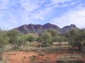
Mount Sonder, the fourth highest mountain in the Northern Territory after nearby Mount Zeil, in West MacDonnell National Park
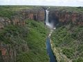
Jim Jim Falls, Kakadu National Park
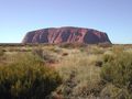
Uluru (Ayers Rock), one of the best known images of the Northern Territory
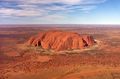
Aerial view of Uluru


المناخ

| متوسط درجات الحرارة في الإقليم الشمالي | ||||
| الشهر | داروين | أليس سپرنگز | ||
|---|---|---|---|---|
| يناير | 31.8 °س | 36.3 °س | ||
| فبراير | 31.4 °س | 35.1 °س | ||
| مارس | 31.9 °س | 32.7 °س | ||
| أبريل | 32.7 °س | 28.2 °س | ||
| مايو | 32.0 °س | 23.0 °س | ||
| يونيو | 30.6 °س | 19.8 °س | ||
| يوليو | 30.5 °س | 19.7 °س | ||
| أغسطس | 31.3 °س | 22.6 °س | ||
| سبتمبر | 32.5 °س | 27.1 °س | ||
| أكتوبر | 33.2 °س | 30.9 °س | ||
| نوفمبر | 33.2 °س | 33.7 °س | ||
| ديسمبر | 32.6 °س | 35.4 °س | ||
| المصدر: مكتب الأرصاد الجوية | ||||
على الرغم من أن حوالي 80% من مساحة الإقليم الشمالي تقع في المنطقة المدارية، إلا أن الجزء الشمالي منه، المعروف باسم الطرف العلوي، والذي يمثل 25% فقط من مساحته، وحده يتسم بالخصائص المعروفة عن المناخ الذي يسود المناطق المدارية. وتتميز تلك المنطقة بغابات الساڤانا وتتناثر فيها بعض مناطق من الغابات الممطرة، أما في الجزء الشمال الشرقي منها فترتفع هضبة "أرنهم لاند" بشكل مفاجئ بدءً من السهل حتى تصل إلى خليج كارپنتاريا. وتتكون غالبية المنطقة الجنوبية من الإقليم، والتي تشكل 75% من مساحته الإجمالية، من صحراء أو سهول شبه جافة. المنطقة الجنوبية الغربية من الإقليم هي سلسلة جبال ماكدونل . أما الأنهار في المقاطعة فهي فيكتوريا ودالي وأدليد وروبر، وجميعها تصب في البحار الشمالية.
وتجدر الإشارة إلى أن المناخ السائد في منطقة الطرف العلوي، شأنه في ذلك شأن بقية المناطق الشمالية في أستراليا (في شمال كلا من أستراليا الغربية وكوينزلاند)، يتميز بأنه يجمع بين الجفاف والمطر، حيث يتفاوت الحد الأقصى لدرجات الحرارة بين 30 و34 درجة مئوية والحد الأدنى بين 19 و26 درجة مئوية، أما في وسط المنطقة، فيتميز المناخ بتقلب درجة الحرارة به بشكل كبير، حيث تهبط إلى ما دون درجة التجمد ليلا في فصل الشتاء وترتفع لتزيد عن 40 درجة في فصل الصيف. ولذا فإن أفضل الفترات المناسبة لزيارة كل من منطقة الوسط والجزء العلوي هي شهري يونيو ويوليو، مع إن المناخ يصبح لطيفاً جداً في منطقة الوسط بدءً من شهر أبريل.
ومن مظاهر الجمال التي يتميز بها الطرف العلوي في فصل الأمطار أن كل شيء يكتسي باللون الأخضر، وإن يكن ذلك مصحوبا بالعواصف الرعدية وبالتالي يقل نسبيا عدد زائريه من السياح. وبالنظر إلى أن ارتفاع درجة الحرارة الذي يصاحبه ارتفاع في مستوى الرطوبة النسبية يؤدي في بعض الأحيان إلى نشوء أوضاع مناخية لا يمكن احتمالها، لذلك يتم إغلاق بعض المنتزهات الوطنية بشكل كلي أو جزئي.
الحكومة

البرلمان
كبير الوزراء ومجلس الوزراء
الاداري
الحكومة الاتحادية

الحكومة المحلية
مجالس أراضي السكان الأصليين
 مقالة مفصلة: مجالس أراضي السكان الأصليين في الإقليم الشمالي
الديموغرافيا

| أعداد السكان في الإقليم الشمالي | |
|---|---|
| 1901 | 4,765 |
| 1956 | 19,556 |
| 1961 | 44,481 |
| 1974 | 102,924 |
| 1976 | 97,090 |
| 1981 | 122,616 |
| 1991 | 165,493 |
| 1996 | 181,843 |
| 2002 | 200,019 |
| 2006 | 192,900 |
| 2011 | 211,945 |
| Source: Australian Bureau of Statistics (Est Resident Pop) | |

.jpg&filetimestamp=20150727220812&)
| الترتيب | القسم/ المنطقة الإحصائية | تعداد السكان 2008–2009 [45] |
|---|---|---|
| 1 | داروين | 124,760 |
| 2 | پالمرستون | 30,005 |
| 3 | أليس سپنگز | 27,877 |
| 4 | كاثرين | 10,095 |
| 5 | نولونباي | 5,001 |
| 6 | تنات كريك | 3,558 |
| 7 | واديه | 2,394 |
| 8 | جابيرو | 1,327 |
| 9 | يولارا | 1,205 |
الدين
التعليم

المكتبات
الاقتصاد

.jpg&filetimestamp=20150727220812)
النقل

.JPG&filetimestamp=20150727214426&)
.JPG&filetimestamp=20150727214426)
الإعلام
المطبوع
التلفزيون
الإذاعة
تقنيات الاتصالات
الرياضة
انظر أيضاً
- مواقع قبل التاريخ للسكان الأصليين الأستراليين
- الجريمة في الإقليم الشمالي
- شرطة الإقليم الشمالي
- قائمة الطرق السريعة في الإقليم الشمالي
- تصنيف:مدن الإقليم الشمالي
- تصنيف:بلدان الإقليم الشمالي
الهوامش
المصادر
- ^ Baker, Sidney J. (1945). The Australian Language. Angus & Robertson. p. 186.
- ^ "Magazine". The Canberra Times. Vol. 65, no. 20, 385. Australian Capital Territory, Australia. 3 February 1991. p. 18. Retrieved 5 September 2023 – via National Library of Australia.
- ^ "National, state and territory population – December 2021". Australian Bureau of Statistics. 28 June 2022. Archived from the original on 29 June 2022. Retrieved 1 July 2022.
- ^ "5220.0 – Australian National Accounts: State Accounts, 2019–20". Australian Bureau of Statistics. 20 November 2020. Archived from the original on 17 June 2016. Retrieved 20 January 2021.
- ^ "Sub-national HDI – Area Database – Global Data Lab". hdi.globaldatalab.org (in الإنجليزية). Retrieved 11 November 2025.
- ^ "Floral Emblem of the Northern Territory". Anbg.gov.auhi. Archived from the original on 25 December 2018. Retrieved 26 March 2008.
- ^ "Northern Territory". Parliament.curriculum.edu.au. Archived from the original on 25 December 2018. Retrieved 22 January 2013.
- ^ خطأ استشهاد: وسم
<ref>غير صحيح؛ لا نص تم توفيره للمراجع المسماةabs - ^ "Definition of Territorian". www.merriam-webster.com (in الإنجليزية). Archived from the original on 17 September 2024. Retrieved 2024-09-17.
- ^ Clarkson, Chris; Jacobs, Zenobia; Marwick, Ben; Fullagar, Richard; Wallis, Lynley; Smith, Mike; Roberts, Richard G.; Hayes, Elspeth; Lowe, Kelsey; Carah, Xavier; Florin, S. Anna; McNeil, Jessica; Cox, Delyth; Arnold, Lee J.; Hua, Quan; Huntley, Jillian; Brand, Helen E. A.; Manne, Tiina; Fairbairn, Andrew; Shulmeister, James; Lyle, Lindsey; Salinas, Makiah; Page, Mara; Connell, Kate; Park, Gayoung; Norman, Kasih; Murphy, Tessa; Pardoe, Colin (2017). "Human occupation of northern Australia by 65,000 years ago" (PDF). Nature. Springer Nature. 547 (7663): 306–310. Bibcode:2017Natur.547..306C. doi:10.1038/nature22968. hdl:2440/107043. ISSN 0028-0836. PMID 28726833. S2CID 205257212. Archived (PDF) from the original on 25 October 2019. Retrieved 24 September 2019.
- ^ أ ب Macknight, Charles Campbell (2011). "The view from Marege': Australian knowledge of Makassar and the impact of the trepangindustry across two centuries". Aboriginal History. 35: 121–143. doi:10.22459/AH.35.2011.06. JSTOR 24046930.
- ^ Taçon et al. 2010.
- ^ Woodford, J. (20 September 2008). "The Rock Art That Redraws Our History". The Sydney Morning Herald. Archived from the original on 20 September 2008. Retrieved 6 April 2012.
- ^ National Museum of Australia (2022-09-28). "National Museum of Australia – Overland telegraph". National Museum of Australia. Archived from the original on 30 March 2020. Retrieved 2025-04-28.
- ^ "Distance from Darwin to Victoria River Downs (DRW – VCD)". Air Miles Calculator (in الإنجليزية). Retrieved 2024-09-17.
- ^ Otterman, D. (2004). Daly River Project, Annual report for EL 22495, EL 22496, EL 22498 and EL 23595, for the period 6 September 2003 to 5 September 2004. Archived from the original. You must specify the date the archive was made using the
|archivedate=parameter. https://geoscience.nt.gov.au/gemis/ntgsjspui/handle/1/83631. Retrieved on 21 July 2021. - ^ Walker, David (1999). Anxious Nation: Australia and the Rise of Asia, 1850–1939. University of Queensland Press. p. 122. ISBN 978-0702231315.
- ^ "The Territory: Federal Policy Criticised". The Advertiser. Adelaide. 14 November 1912.
- ^ "House of Representatives". The Sydney Morning Herald. 14 November 1912.
- ^ "Territoria or Kingsland!". The Register. 16 April 1914.
- ^ "Kingsland: New name for the Northern Territory". The Advertiser. 22 April 1913. Archived from the original on 10 December 2019. Retrieved 1 May 2017.
- ^ "Wasted Years". The Sydney Morning Herald. No. 34, 577. New South Wales, Australia. 16 October 1948. p. 6. Retrieved 20 July 2019 – via National Library of Australia.
- ^ "Immigration Scheme That Failed". The Advertiser (Adelaide). Vol. 91, no. 28178. South Australia. 29 January 1949. p. 8. Retrieved 20 July 2019 – via National Library of Australia.
- ^ أ ب O'Brien, Anne (2015). "Hunger and the humanitarian frontier". Aboriginal History. Aboriginal History Inc. ANU Press. 39. Archived from the original on 4 June 2023. Retrieved 30 May 2023.
- ^ Bradley, Michael (2019). Coniston. Perth: UWA Press. ISBN 9781760801045.
- ^ "Some Known Frontier Conflicts in the Northern Territory". Australian Frontier Conflicts (in الإنجليزية الأسترالية). Archived from the original on 17 September 2024. Retrieved 2024-09-17.
- ^ Thiem, David. "Semaphore: 75 Years After the Bombing of Darwin a Story of Reconciliation Hope and Peace". Semaphore. Royal Australian Navy. Archived from the original on 14 June 2024. Retrieved 14 June 2024.
- ^ [1][dead link]
- ^ Australia, ed. (30 April 1977). Darwin and Northern Territory freight transport study. Australian Government Publishing Service. ISBN 9780642033512. Archived from the original on 30 April 2019. Retrieved 30 April 2019 – via National Library of Australia (new catalog).
- ^ أ ب "Northern Territory Council for Aboriginal Rights". National Museum of Australia. 26 November 2018. Archived from the original on 14 May 2021. Retrieved 30 November 2020.
- ^ "Aboriginal Land Rights (Northern Territory) Act 1976". legislation.gov.au. Archived from the original on 17 January 2022. Retrieved 2022-03-01.
- ^ Reserve Bank of Australia (30 October 2015). "Inflation Calculator". Archived from the original on 25 June 2020. Retrieved 19 July 2019.
- ^ "Northern Territory - Indigenous, Autonomy, Self-Government | Britannica". www.britannica.com (in الإنجليزية). 2024-09-17. Archived from the original on 18 September 2024. Retrieved 2024-09-18.
- ^ "History of Self Government". Territory Day (in الإنجليزية الأسترالية). 2020-05-13. Archived from the original on 9 September 2024. Retrieved 2024-09-18.
- ^ Government, Northern Territory (2023-09-22). "Role of the Administrator". govhouse.nt.gov.au (in الإنجليزية). Retrieved 2024-09-18.
- ^ Government, Northern Territory (2024-07-18). "Government Gazettes". nt.gov.au (in الإنجليزية). Archived from the original on 30 September 2024. Retrieved 2024-09-18.
- ^ "Select Committee on Euthanasia". Legislative Assembly of the Northern Territory. 13 September 2007. Archived from the original on 2 March 2011.
- ^ Fedele, Robert (2024-02-11). "How the Northern Territory trailblazed Australia's voluntary assisted dying laws". Australian Nursing & Midwifery Journal (in الإنجليزية الأسترالية). Archived from the original on 7 September 2024. Retrieved 2024-09-18.
- ^ Maitland-Newcastle, Catholic Diocese of. "Philip Nitschke and 'rational suicide' | Catholic Diocese of Maitland-Newcastle". www.mn.catholic.org.au. Archived from the original on 18 September 2024. Retrieved 2024-09-18.
- ^ Davey, Melissa (2016-04-22). "Philip Nitschke, the man who thinks we should all choose when to die". The Guardian (in الإنجليزية البريطانية). ISSN 0261-3077. Archived from the original on 8 October 2016. Retrieved 2024-09-18.
- ^ "Fires around Darwin, Australia August 21, 2013". Earthobservatory.nasa.gov. 21 August 2013. Archived from the original on 9 May 2016. Retrieved 17 July 2016.
- ^ "World Heritage: Uluru-Kata Tjuta National Park". parksaustralia.gov.au (in الإنجليزية الأسترالية). Retrieved 2024-09-18.
- ^ "World Heritage: Kakadu". parksaustralia.gov.au (in الإنجليزية الأسترالية). Archived from the original on 18 September 2024. Retrieved 2024-09-18.
- ^ "Hay River". Bonzle.com. Archived from the original on 26 July 2020. Retrieved 10 June 2019.
- ^ "3218.0 – Regional Population Growth, Australia, 2006–07". Australian Bureau of Statistics.
المراجع
- Hill, Ernestine. 1951. The Territory: The classic saga of Australia's far north. Angus & Robertson. Reprint: 1995. ISBN 0-207-18821-1
- Govan, A. (2007) Broadband debate key to NT's future. N.T. Business Review, vol. N/A, no. N/A, p. 7
- Morrison, P. (2000) a pilot implementation of internet access for remote aboriginal communities in the "Top end" Of Australia. Urban Studies, Vol. 37, No.10, pp. 1781–1792.
- Toyne, P. (2002) Northern Territory Governments Response to the House of Representatives Communications, Information Technology & the Arts Committee inquiry into Wireless Broadband Communications. In N.T. GOVERNMENT (Ed.) (pp. 3). Darwin: Northern Territory Government.
- Toyne, P. (2003) Remote Areas Telecommunications Strategy 2003–2008. In N. T. GOVERNMENT (Ed.) (pp. 1– 32). Darwin N.T. viewed 6 February 2008, <[2]>
وصلات خارجية
- Northern Territory Government of Australia
- Northern Territory Visitor's Guide
- Australian Bureau of Statistics (27 April 2007). "Northern Territory at a Glance, 2007" (PDF 855 kB).
 Geographic data related to الإقليم الشمالي (أستراليا) at OpenStreetMap
- Northern Territory Weather and Warnings Summary from the Bureau of Meteorology
- Northern-Territory Northern Territory Climate
- Northern Territory economy/mining
- Northern Territory Universities
- Northern Territory Population estimates June 2007
- June 2007 NT population estimates
| موضوعات | ||
|---|---|---|
| المناطق | ||
| المدن الرئيسية | ||
قالب:Energy in the Northern Territory
| الولايات والأقاليم | نيوساوث ويلز · كوينزلاند · أستراليا الجنوبية · تاسمانيا · ڤيكتوريا · أستراليا الغربية الأقاليم: اقليم العاصمة الأسترالية · اقليم جرڤيس باي · الاقليم الشمالي | |
|---|---|---|
| أقاليم خارجية | ||
| أقاليم سابقة | ||
| التاريخ | خط زمني · قبل التاريخ · الآثار الأسترالية · الاستكشاف · 1606–1787 · 1788–1850 · 1851–1900 · 1901–1945 · منذ 1945 · الدستوري · الدبلوماسي · الاقتصادي · الاتحاد · الهجرة · السكان الأصليون · العسكري · الملكية · السكك الحديدية |
|---|---|
| الجغرافيا | الولايات والمناطق · العواصم · المدن · المدن حسب التعداد · المناخ · القارة · الصحاري · البيئة · الفلورا · الفونا · الغابات · الجيولوجيا · الجزر · الجبال · المناطق · المناطق المحمية · الأنهار |
| الحكومة | |
| السياسة | |
| الاقتصاد | الزراعة · الشركات · الطاقة · Home ownership · التشرد · الصناعة · الاعلام · التعدين · الفقر · الضرائب · الاتصالات · السياحة · المواصلات · الدولار الأسترالي · بنك الاحتياط · البورصة · دخل الأسرة · Gross state product · نظام الضمان الاجتماعي |
| الثقافة | العمارة · الفنون · اللغة الإنگليزية الأسترالية · السينما · المطبخ · النبيذ · الرقص · السكان الأصليون · الأدب · الموسيقى · العطلات العامة · الأديان · الرياضة · التلفزيون · المسرح · الفنون البصرية |
| الرموز | |
| موضوعات أخرى | |
خطأ استشهاد: وسوم <ref> موجودة لمجموعة اسمها "lower-alpha"، ولكن لم يتم العثور على وسم <references group="lower-alpha"/>
- Pages using gadget WikiMiniAtlas
- CS1: Julian–Gregorian uncertainty
- CS1 الإنجليزية الأسترالية-language sources (en-au)
- Articles with dead external links from July 2012
- CS1 الإنجليزية البريطانية-language sources (en-gb)
- Short description is different from Wikidata
- Coordinates on Wikidata
- Pages using infobox political division with unknown parameters
- Articles with hatnote templates targeting a nonexistent page
- Articles with unsourced statements from September 2024
- مقالات فيها عبارات متقادمة منذ 2018
- جميع المقالات التي فيها عبارات متقادمة
- Articles with unsourced statements from November 2020
- Articles with unsourced statements from June 2021
- Pages with empty portal template
- Pages with single-entry sister bar
- الإقليم الشمالي (أستراليا)
- ولايات وأقاليم تأسست في 1911
- ولايات وأقاليم أستراليا
- تأسيسات 1911 في أستراليا