مقاطعة همبولت، كاليفورنيا
مقاطعة همبولت
County of Humboldt | |
|---|---|
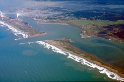 منظر جوي لـخليج همبولت | |
 Interactive map of Humboldt County | |
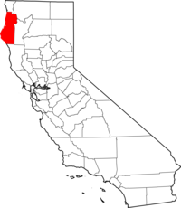 Location in the state of California | |
| البلد | |
| State | |
| المنطقة | الساحل الشمالي لكاليفورنيا |
| Incorporated | May 12, 1853[1] |
| السمِيْ | خليج همبولت |
| مقر المقاطعة | يوريكا |
| Largest city | Eureka |
| المساحة | |
| • الإجمالي | 4٬052 ميل² (10٬490 كم²) |
| • البر | 3٬568 ميل² (9٬240 كم²) |
| • الماء | 484 ميل² (1٬250 كم²) |
| أعلى منسوب | 6٬960 ft (2٬120 m) |
| التعداد | |
| • الإجمالي | 134٬623 |
| • Estimate (2016)[3] | 136٬646 |
| • الكثافة | 33/sq mi (13/km2) |
| منطقة التوقيت | UTC-8 (Pacific Time Zone) |
| • الصيف (التوقيت الصيفي) | UTC-7 (Pacific Daylight Time) |
| مفتاح الهاتف | 707, 530 |
| الموقع الإلكتروني | www.humboldtgov.org |
مقاطعة همبولت إنگليزية: Humboldt County هي مقاطعة في الجزء الشمالي الغربي لولاية كاليفورنيا في الولايات المتحدة. As of the 2020 census, the population was 136,463.[4] The county seat is Eureka.[5]
Humboldt County comprises the Eureka–Arcata–Fortuna, California, Micropolitan Statistical Area. It is located on the far North Coast of California, about 270 ميل (435 km) north of San Francisco. It has among the most diverse climates of United States counties, with very mild coastal summers and hot interior days. Similar to the greater region, summers are extremely dry and winters have substantial rainfall.
Its primary population centers of Eureka, the site of College of the Redwoods main campus, and the smaller college town of Arcata, site of California State Polytechnic University, Humboldt, are located adjacent to Humboldt Bay, California's second largest natural bay.[6] Area cities and towns are known for hundreds of ornate examples of Victorian architecture.
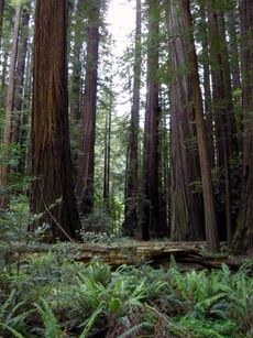
Humboldt County is a densely forested mountainous and rural county with about 110 ميل (177 km) of coastline (more than any other county in the state),[7] situated along the Pacific coast in Northern California's rugged Coast (Mountain) Ranges. With nearly 1،500،000 acre (6،100 km2) of combined public and private forest in production, Humboldt County alone produces twenty percent of the total volume and thirty percent of the total value of all forest products produced in California.[8] The county contains over forty percent of all remaining old growth Coast Redwood forests,[9] the vast majority of which are protected or strictly conserved within dozens of national, state, and local forests and parks, totaling approximately 680،000 acre (1،060 sq mi).[10]
التاريخ
The original inhabitants of the area now known as Humboldt County include the Algic Wiyot, Yurok; the Hokan Karuk; and the Athapaskan Hupa, Chilula, Whilkut, Tsnungwe as well as the Eel River Athapaskan peoples, including the Wailaki, Mattole and Nongatl.[11]
Spanish traders made unintended visits to California with the Manila Galleons on their return trips from the Philippines beginning in 1565. The first recorded entry by people of European origin was a landing by the Spanish in 1775 in Trinidad.[11]
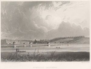
The first recorded entry of Humboldt Bay by non-natives was an 1806 visit from a sea otter hunting party from Sitka employed by the Russian American Company.[11] The hunting party included Captain Jonathan Winship, an American, and some Aleut hunters.[11][12] The bay was not visited again by people of European origin until 1849 when Josiah Gregg's party visited.[12] In 1850, Douglas Ottinger and Hans Buhne entered the bay, naming it Humboldt in honor of the great naturalist and explorer Alexander von Humboldt, and the name was later applied to the county as a whole.[13]
The area around Humboldt Bay was once solely inhabited by the Wiyot Indian tribe. One of the largest Wiyot villages, Tolowot, was located on Indian Island in Humboldt Bay. Founded around 900 BC, it contains a shell midden 6 acre (2.4 ha) in size and 14 أقدام (4.3 m) deep. It was the site of the February 26, 1860, massacre of the Wiyot people that was recorded by Bret Harte, then living in Union, now called Arcata. Between 60 and 200 Wiyot men, women, and children were murdered that night in the midst of a religious ceremony. Tolowot is now a restricted site and a National Historic Landmark.[12] In 2019, the island was restored to the Wiyot tribe, and is now known as Tuluwat or Duluwat island.
أنشئت مقاطعة همبولت في 1853 من أجزاء تابعة لمقاطعة ترينيتي.
State historic landmarks in Humboldt County include Arcata and Mad River Railroad, California's First Drilled Oil Wells in Petrolia, Camp Curtis, Centerville Beach Cross, the city of Eureka, the Victorian town of Ferndale, Fort Humboldt, Humboldt Harbor Historical District, the Jacoby Building, The Old Arrow Tree, Old Indian Village of Tsurai, the Town of Trinidad, and Trinidad Head.[12]
On February 5 and 6, 1885, Eureka's entire Chinese population of 300 men and 20 women were expelled after a gunfight between rival Chinese gangs (tongs) resulted in the wounding of a 12-year-old boy and the death of 56-year-old David Kendall, a Eureka City Councilman. After the shooting, an angry mob of 600 Eureka residents met and informed the Chinese that they were no longer wanted in Eureka and would be hanged if they were to stay in town past 3 p.m. the next day. They were put on two steamships and shipped to San Francisco. No one was killed in the expulsion. Another Chinese expulsion occurred during 1906 in a cannery on the Eel River, in which 23 Chinese cannery workers were expelled after objections to their presence. However, some Chinese remained in the Orleans area, where some white landowners sheltered and purchased food for the Chinese mineworkers until after racial tension passed. Chinese did not return to the coastal cities until the 1950s.[14]
الجغرافيا
According to the United States Census Bureau, Humboldt County encompasses 4،052 ميل مربع (10،490 km2), of which 3،568 ميل مربع (9،240 km2) is land and 484 ميل مربع (1،250 km2) is water.[15]
Cape Mendocino is the westernmost point in California (longitude 124 degrees, 24 minutes, 30 seconds). Humboldt Bay, the only deepwater port between San Francisco and Coos Bay, Oregon, is located on the coast at the midpoint of the county.
Humboldt County contains a diversity of plant and animal species, with significant forest and coastal habitats. In coastal areas there are extensive redwood forests.[16] A prominent understory shrub is the toyon, whose northern range limit is in Humboldt County.[17]
الأنهار

Humboldt County's major rivers include (in order of flow – in cubic meters per second – from largest to smallest):
The smaller rivers include Redwood Creek, significant due to amount of its flow; the Van Duzen; the Eel River syncline group composed of the South Fork, the North Fork, and the Salt River; the Mattole, Salmon, Elk, Bear, and Little rivers.
النشاط الزلزالي
Historically, Humboldt County and the entire far north coast of California have had many earthquakes over 6.0 magnitude. The Mendocino fracture zone is in the area.[18]
The 1992 Cape Mendocino earthquakes were a series of three major earthquakes that occurred off the coast of Cape Mendocino, California on April 25 and 26, 1992, the largest being a 7.2. Ninety-five people were injured and property in the county sustained considerable damage.[19]
In 2010, a 6.5 magnitude earthquake struck offshore, 33 mi (53 km) west of Eureka, resulting in only minor injuries and some structural damage to houses and utilities, and no fatalities reported.[20]
In 2022, a 6.4 magnitude earthquake centered approximately 10 ميل (16 km) from Ferndale caused damage, especially in Rio Dell.[21]
The 2024 Cape Mendocino earthquake was a Mww 7.0 earthquake with an epicenter off the coast of Humboldt County.[18]
The town of Arcata is built on top of an accretionary wedge. This was formed by the subduction of the Gorda plate under the North American plate.[22]
المناخ
| الموقع | الشهر | Temp (°ف) | Temp (°س) | الشهر | Temp (°ف) | Temp (°س) |
|---|---|---|---|---|---|---|
| يوريكا | أغسطس | 64/52 | 18/11 | ديسمبر | 55/40 | 12/4 |
| Arcata | September | 62/51 | 17/11 | December | 54/38 | 12/3 |
| Ferndale | August | 71/52 | 22/11 | December | 56/39 | 13/4 |
| Willow Creek | July | 94/52 | 34/11 | December | 50/35 | 10/1 |
| Garberville | August | 87/53 | 31/12 | December | 49/37 | 9/3 |
| Shelter Cove | August | 69/53 | 21/11 | January | 57/45 | 14/7 |
| أوريك | أغسطس | 69/49 | 21/9 | يناير | 52/37 | 11/2 |
انظر أيضاً
- Arcata and Eureka Community Recycling Centers
- Arcata - Jacoby Creek Community Forests
- Arcata Marsh and Wildlife Sanctuary
- HSU First Street Gallery
- Humboldt Arts Council
- Humboldt County Historical Society
- Humboldt Crabs - semi-professional baseball team
- National Register of Historic Places listings in Humboldt County, California
- Operation Green Sweep
- Humboldt State University
ملاحظات
الهامش
- ^ Kerr, J.M. - The Codes of California. - 1905. - p.1043.
- ^ "Salmon Mountain". Peakbagger.com. Retrieved مايو 22, 2015.
- ^ أ ب "Annual Estimates of the Resident Population: April 1, 2010 to July 1, 2016 Estimates". Retrieved أبريل 27, 2017.
- ^ "State & County QuickFacts". United States Census Bureau. Archived from the original on فبراير 24, 2016. Retrieved أبريل 11, 2018.
- ^ "Find a County". National Association of Counties. Archived from the original on مايو 31, 2011. Retrieved يونيو 7, 2011.
- ^ "Humboldt Bay Harbor District |". humboldtbay.org. Retrieved أبريل 27, 2023.
- ^ "California Coastal Trail.info". Archived from the original on يونيو 23, 2013. Retrieved سبتمبر 3, 2013.
- ^ Forestry, Forest Industry, and Forest Products Consumption in California Archived فبراير 21, 2011 at the Wayback Machine. University of California, Davis: Division of Agriculture and Natural Resources (Adobe Acrobat *.PDF document). Retrieved: March 30, 2008.
- ^ Area of Old-Growth Forests in California, Oregon, and Washington. – United States Forest Service – USDA. (Adobe Acrobat *.PDF document). Retrieved: November 18, 2007.
- ^ "About Us | Humboldt County, California – Official Website". humboldtgov.org. Retrieved أبريل 27, 2023.
- ^ أ ب ت ث Van Kirk, Susie, Humboldt County: A Briefest of Histories Archived أغسطس 27, 2008 at the Wayback Machine, Humboldt County Historical Society, May 1999.
- ^ أ ب ت ث Humboldt County State Designated Historical Landmarks Archived مارس 23, 2012 at the Wayback Machine. California Historical Landmarks.
- ^ "Why is Everything Named Humboldt?". Our City Forest (in الإنجليزية الأمريكية). يونيو 24, 2016. Retrieved أبريل 27, 2023.
- ^ "North Coast Journal – Feb. 207, 2003: COVER STORY – The Chinese Expulsion – Looking Back on a dark episode". www.northcoastjournal.com. Retrieved أبريل 27, 2023.
- ^ "2010 Census Gazetteer Files". United States Census Bureau. أغسطس 22, 2012. Retrieved سبتمبر 26, 2015.
- ^ Neil G. Sugihara, Jan W. Van Wagtendonk, Kevin E. Shaffer, JoAnn Fites-Kaufman, Andrea E. Thode (2006) Fire in California's Ecosystems, University of California Press, 596 pages. ISBN 0-520-24605-5.
- ^ C. Michael Hogan (2008) Toyon: Heteromeles arbutifolia, GlobalTwitcher.com, ed. N. Stromberg "Toyon (Heteromeles arbutifolia ) – GlobalTwitcher.com". Archived from the original on سبتمبر 6, 2009. Retrieved ديسمبر 16, 2008.
- ^ أ ب Bush, Evan (ديسمبر 5, 2024). "Tsunami warnings triggered in California and Oregon after 7.0-magnitude earthquake". Retrieved ديسمبر 5, 2024.
- ^ Cape Mendocino, California Earthquakes Archived ديسمبر 1, 2016 at the Wayback Machine, U.S.G.S. (April 25, 1992).
- ^ Magnitude 6.5 – OFFSHORE NORTHERN CALIFORNIA Archived أكتوبر 11, 2012 at the Wayback Machine, U.S.G.S. (January 9, 2010).
- ^ Johnson, Julie; Flores, Jessica; Morris, J. D.; Tucker, Jill (ديسمبر 20, 2022). "Two dead in 6.4 magnitude California earthquake that caused widespread damage". San Francisco Chronicle (in الإنجليزية الأمريكية). Retrieved مارس 10, 2023.
- ^ Thompson, Jerry (مارس 10, 2012). Cascadia's Fault. Counterpoint Press. p. 352. ISBN 978-1582438245.
"The towns of Eureka and Arcata were built on top of it..." (the accretionary wedge).
- ^ "California climate averages". Weatherbase. Retrieved أكتوبر 31, 2015.
للاستزادة
- Emerson, F. W. (يوليو 1903). "Among The Redwoods of Humboldt County". Overland Monthly. XLII: 69–96.
{{cite journal}}: Cite has empty unknown parameter:|coauthors=(help)
وصلات خارجية
- Official website

- Humboldt Economic Index
- All About Living in Humboldt County
- General Guide to Humboldt County

|
مقاطعة سيسكيو | مقاطعة دل نورتى | 
| |
| مقاطعة ترينيتي | المحيط الهادي | |||
| مقاطعة مندوسينو |
قالب:Humboldt County, California قالب:North Coast (California)
- CS1 الإنجليزية الأمريكية-language sources (en-us)
- Short description is different from Wikidata
- Use American English from June 2025
- All Wikipedia articles written in American English
- Use mdy dates from April 2024
- صفحات تستخدم جدول مستوطنة بقائمة محتملة لمفاتيح الهاتف
- Pages using infobox settlement with no coordinates
- Articles containing إنگليزية-language text
- Pages using Lang-xx templates
- Pages with empty portal template
- Portal-inline template with redlinked portals
- مقاطعات كاليفورنيا
- مقاطعة همبولت، كاليفورنيا
- تأسيسات 1853 في الولايات المتحدة
- أماكن مأهولة تأسست في 1853
- ألكسندر فون همبولت
- صفحات مع الخرائط
